River Gungo
The Gungo is the most important river in the Kingdom of Danagunda. At its mouth it about 11 km wide, making it one of the broadest rivers in the world.
Munatanplugin-autotooltip__small plugin-autotooltip_bigMunatan (Category)
Articles about Munatan, the far southern region of Anásthias.
Nations
Cities
topics regi1
 Hover mouse to see more detail | Go to full atlas mapplugin-autotooltip__small plugin-autotooltip_bigAtlas: Munatan
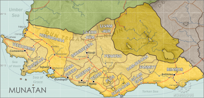
[munatan.png] * Zoom out * East Munatan * West Munatan
Munatan
Munatan [Moo-Nah-Tahn] is the southernmost region of Anásthias, south of the Dun Trisan mountains. The name possibly derives from a ancient OrorrOrorrOrorrHartheraHartheraOrorrOrorrOrorrHartheraHarthera
This is in a series of articles about Munatanplugin-autotooltip__small plugin-autotooltip_bigMunatan
Munatan [Moo-Nah-Tahn] is the southernmost region of Anásthias, south of the Dun Trisan mountains. The name possibly derives from a ancient Thalsic, meaning “Land of One Sun”, since the daystar is not visible in the southern hemisphere. Or it may be a reference to the Manthi people who were once the majority population of western Munatan. The term is an OrorrOrorrOrorrHartheraHartheraOrorrOrorrOrorrHartheraHarthera, the temperate region of southern Anásthiasplugin-autotooltip__small plugin-autotooltip_bigAnásthias
Anásthias [a-NAS-thee-ass / ænæsθiːæs], or [an-ass-THEE-as] is an equatorial island continent, heart of the Civilised World. The north straddles the equator and is hot and humid, while most of the equatorial centre is an upland plateau with fertile river valleys, and stretches of arid plains and desert in the shadow of the mountains. The south is temperate but more wild, separated from the civilisations of the north by the almost impassable Harthera.
Consequently there are no bridges on the lower reaches of the river. It gradually narrows inland and is navigable to about 100 km, where it divides into many much smaller, non-navigable rivers.
The city of Gundapor is its most important city, lying on its eastern bank approximately 14 km inland.
The Gungo was the traditional boundary between the Ennseperan Empire and the Manthi-Lien to the east.