Mathé Marshes
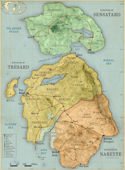
The Mathé Marshes [MATH-ay] are an area of tidal mud flats, salt marshes and wetlands in the estuary of the River Kethel in the Anrel Isles. The marshes form a natural boundary between the Kingdom of Trésard and the Kingdom of Narette. The Muthené Marsh in Trésard is an extension of the Mathé Marshes.
Anrelplugin-autotooltip__small plugin-autotooltip_bigAnrel (Category)
Topics related to the Anrel Isles.
Anrel
Hover/tap image to magnify | Go to world atlas
This is in a series of articles about the Anrel Isles, a significant archipelago in the Natorn Sea.
Nations
Nation Subcategories
Other articles
topics nati1 regi1
 Hover/tap image to magnify | Go to world atlasplugin-autotooltip__small plugin-autotooltip_bigAtlas: Anrel Isles
[fmap-anrel_isles.png] * Zoom out * Sensatard * Trésard * Anret
Anrel Isles
Anrel [ANN-rel], or the Anrel Isles, is the most northerly island group in the Natorn Archipelago. It consists of three major islands and numerous smaller ones. The largest, colloquially if infrequently called Mainland, is divided between the kingdoms of
This is in a series of articles about the Anrel Islesplugin-autotooltip__small plugin-autotooltip_bigAnrel Isles
Alternate name for Anrel., a significant archipelago in the Natorn Seaplugin-autotooltip__small plugin-autotooltip_bigNatorn Sea
The Natorn Sea is a region of oceanic ridge, separating the Polassirn Ocean and the Redeeming Ocean. Islands in the ridge form the Natorn Archipelago.
Etymology
The name may be derived from ancient Ahngrit, meaning “near/of our birth”, referring to the legend of the Godmen in which humanity is said to have originated in region now lost beneath the sea. It also relates to the god.
History
In previous epochs when sea levels were lower, the region was the flat fertile valley of the River Kethel. This region was one of the richest in Anrelplugin-autotooltip__small plugin-autotooltip_bigAnrel Isles
Anrel [ANN-rel], or the Anrel Isles, is the most northerly island group in the Natorn Archipelago. It consists of three major islands and numerous smaller ones. The largest, colloquially if infrequently called Mainland, is divided between the kingdoms of Trésard and Narette. The island, home to prosperous towns and cities. These were flooded at the start of the Beryl Epoch.
During the Little Ice Age sea levels fell and the marshes dried out, revealing the land and the ruins of ancient settlements. The scramble for control of the Kethel Valley was one of the major causes of the Long War.
