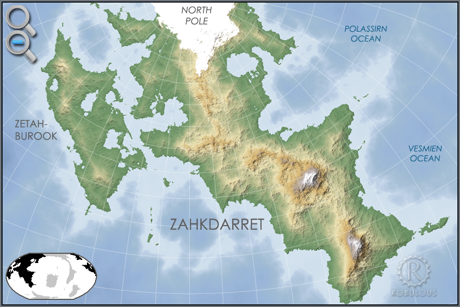
Atlas: Zahkdarret

Zahkdarret
Zahkdarret is the largest continent of Helevosplugin-autotooltip__small plugin-autotooltip_bigHelevos
Helevos (also known as Vos, or Veeos) is a temperate terrestrial world, fourth planet of the star Cordes in the Cronox binary star system. The stars Cordes and Arjos are distant binaries, so on Helevos, Arjos is only seen in the northern hemisphere as star, sometimes bright enough to be seen during the day, circling roughly over the viridgreenAnásthiasAnásthiasAnásthiasgreen, encompassing most of the western hemisphere to the west and north of Anásthias.
 North polar projection of the Zahkdarret-Retzayk landmass, showing the average range of north polar ice

In Mayapoplugin-autotooltip__small plugin-autotooltip_bigMayápo Language
Mayápo or Mayápon [may-YAPP-poe] was the formal language of the ancient realm of Miyarris, spoken for several thousand years in the Celadon Epoch and after.
Language
language
This is in a series of articles about Languages and Communication.
Though it been extinct as a spoken language for almost two thousand years, it continued to be used throughout the Eloyounlanguagelanguagelanguagegreengreengreengreengreen it means “Lands of Cold and Sun”, or more poetically The Lands of Fire and Ice. Zahkdarret, Retzaykplugin-autotooltip__small plugin-autotooltip_bigRetzayk
Retzayk is a long, narrow continent approximately 4500 km east of Anásthias, separated from it by the Redeeming Ocean. It extends from the North Pole, crossing the equator and deep into the southern hemisphere.
retzayk
Eastern continent of Retzayk
According to contemporary geography, Retzayk is believed to be one of the Anásthiasviridviridvirid and the island continent of Zetahburookplugin-autotooltip__small plugin-autotooltip_bigZetahburook
Zetahburook [zeh-TAH-boo-rook] is a large island continent to the west of Zahkdarret, approximately 9000 km east-west and 8500 km north-south. It forms part of the Zahkdarret-Retzayk supercontinent.
Zetahburook is mostly hot, wet and low-lying, covered in virid jungle and swamp, dotted with hundreds of lakes and several huge inland seas. The three largest bodies of fresh water in the world are found on this continent. in fact form a single supercontinentplugin-autotooltip__small plugin-autotooltip_bigZahkdarret-Retzayk
Zahkdarret-Retzayk is a supercontinental landmass consisting of Zahkdarret, Retzayk and the island continent Zetahburook. This contiguous landmass covers most of the northern hemisphere.
North polar projection of the Zahkdarret-Retzayk landmass, showing the average range of north polar ice, separated from each other by the arctic ice cap.
According to traditional duospherical theoryplugin-autotooltip__small plugin-autotooltip_bigDuospherical Theory
Duospherical Theory is a geographical theory that the world of Helevos is a sphere, with two hemispheres which are the physical reverse of each other. It has been the dominant theory for more than a millennium, with world maps showing Anásthias, the Civilised Worldplugin-autotooltip__small plugin-autotooltip_bigCivilised World
The Civilised World refers to the known regions of human civilisation, notably the continent of Anásthias, the Natorn Archipelago and surrounding islands.
Gastrinimer's 3rd century BME Map of the World, showing Anásthias and the Natorn Isles. Note: old maps place north to the right.AnásthiasAnásthiasAnásthiasAnásthias is a circular sea surrounded by the “Edge Lands”. According to this understanding, Zahkdarret is merely the land to the west, and the frozen north is called the Ice Realmplugin-autotooltip__small plugin-autotooltip_bigThe Icerealm
The Icerealm is the traditional name for the frozen lands to the north of the Civilised World, one of the Edge Lands that surrounds the known world. The arctic region is in fact part of the continent of Zahkdarret.
In Anrel, “The Ice Realm” is also a name for the mythic land of.
