Tour
Helevos
Helevos (also known as Vos, or Veeos) is a temperate terrestrial world, fourth planet of the star Cordes in the Cronox binary star systemplugin-autotooltip__small plugin-autotooltip_bigCronox System
Planets of the Cronox-Cordes system
Terrestrial planets of Cordes, to scale
Position of Cronox in Syndicate space
Cronox [CRON-ox] is a S-type detached-binary star system consisting of the stars 1GD.Pa-Cordes and 1GD.Pb-Arjos. The two orbit a common barycenter at a sufficient distance for each to have its own independent planetary system. The two stars' orbital planes are at 83 degree angle from each other, which suggests that the two stars originally formed independently o…. The stars Cordes and Arjos are distant binaries, so on Helevos, Arjos is only seen in the northern hemisphere as star, sometimes bright enough to be seen during the day, circling roughly over the north poleplugin-autotooltip__small plugin-autotooltip_bigRetzayk
Retzayk is a long, narrow continent approximately 4500 km east of Anásthias, separated from it by the Redeeming Ocean. It extends from the North Pole, crossing the equator and deep into the southern hemisphere.
retzayk
Eastern continent of Retzayk
According to contemporary geography, Retzayk is believed to be one of the Anásthiasviridviridvirid.
 plugin-autotooltip__small plugin-autotooltip_bigAtlas: Helevos interactive map
[fmap-hemispheres.png] * Zoom in * Zoom out * Planets * Moons * North Pole * South Pole * The Obverse * The Civilised World
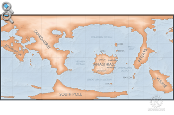
Physical/Political map of Helevos. Click red flags to zoom in, or nav buttons to zoom out
< Historical world map
atlas
- Name: Helevos, Vos, 1GD.Ca.4
- Primary: Cordes
- Mean Radius: 5682 km
- Surface Gravity: 9.46 metres/sec squared (0.962 G)
- Rotation: 22 hours (standard)
- Orbital Period: 414.18 days (local) 1.04 years (standard)
- Axial Tilt: 10.6 degrees (range 10.1-18.7)
- Affiliation: Protectorate world, non-spacefaring


Climate
Helevos is cooler than Earth, with the poles being much cooler. Comfortable range for human habitation is from the equator to 40 degrees north or south.
Due to oscillations in axial tilt and orbital precession, the world goes through a cycle of cooler and warmer periods lasting approximately 30,000 years. During the cooler periods, ice builds up on the polar continents, causing a dramatic lowering of sea level causing the land masses to grow in size. In the warmer periods ice melts, inundating low-lying land. This has a profound effect on human civilisation, with climate change and flooding regularly destroying the most advanced civilisations of the era leading to a generally low level of technology.
Geography
Helevos has six continentsplugin-autotooltip__small plugin-autotooltip_bigContinents
topics geog1, depending on definition.
- Anásthiasplugin-autotooltip__small plugin-autotooltip_bigAnásthias
Anásthias [a-NAS-thee-ass / ænæsθiːæs], or [an-ass-THEE-as] is an equatorial island continent, heart of the Civilised World. The north straddles the equator and is hot and humid, while most of the equatorial centre is an upland plateau with fertile river valleys, and stretches of arid plains and desert in the shadow of the mountains. The south is temperate but more wild, separated from the civilisations of the north by the almost impassable Harthera, an equatorial island continent, is the centre of human civilisation. Its inhabitants refer to it and surrounding islands as the “Civilised Worldplugin-autotooltip__small plugin-autotooltip_bigCivilised World
The Civilised World refers to the known regions of human civilisation, notably the continent of Anásthias, the Natorn Archipelago and surrounding islands.
Gastrinimer's 3rd century BME Map of the World, showing Anásthias and the Natorn Isles. Note: old maps place north to the right.AnásthiasAnásthiasAnásthiasAnásthias”. - Dahroshahpplugin-autotooltip__small plugin-autotooltip_bigSouth Pole
The South Pole region consists of a permanent cap of ice covering sea, numerous islands and one large island continent, mostly concealed within a pack of sea ice which encompasses latitudes from roughly 75°C to the pole. The ice also encompasses the southern tip of the continent of, more commonly known as the Icehornsplugin-autotooltip__small plugin-autotooltip_bigIcehorns
Part of the coastline of the South Pole continent., is an island continent at the South Poleplugin-autotooltip__small plugin-autotooltip_bigSouth Pole
The South Pole region consists of a permanent cap of ice covering sea, numerous islands and one large island continent, mostly concealed within a pack of sea ice which encompasses latitudes from roughly 75°C to the pole. The ice also encompasses the southern tip of the continent of. - Voulimayplugin-autotooltip__small plugin-autotooltip_bigVoulimay
Alternate spelling for the island continent of Vulimé., an island continent in the temperate southern hemisphere. - Zahkdarretplugin-autotooltip__small plugin-autotooltip_bigZahkdarret
Zahkdarret is the largest continent of Helevos, encompassing most of the western hemisphere to the west and north of Anásthias.
North polar projection of the Zahkdarret-Retzayk landmass, showing the average range of north polar ice
In Mayapo it means “ covers most of the north-western hemisphere including the north pole. - Retzaykplugin-autotooltip__small plugin-autotooltip_bigRetzayk
Retzayk is a long, narrow continent approximately 4500 km east of Anásthias, separated from it by the Redeeming Ocean. It extends from the North Pole, crossing the equator and deep into the southern hemisphere.
retzayk
Eastern continent of Retzayk
According to contemporary geography, Retzayk is believed to be one of the Anásthiasviridviridvirid is a long peninsula extending from it into the eastern hemisphere. It is geographically connected to Zahkdarret, but isolated from it by the north polar ice. - Zetahburookplugin-autotooltip__small plugin-autotooltip_bigZetahburook
Zetahburook [zeh-TAH-boo-rook] is a large island continent to the west of Zahkdarret, approximately 9000 km east-west and 8500 km north-south. It forms part of the Zahkdarret-Retzayk supercontinent.
Zetahburook is mostly hot, wet and low-lying, covered in virid jungle and swamp, dotted with hundreds of lakes and several huge inland seas. The three largest bodies of fresh water in the world are found on this continent. is a low-lying island continent to the west of Zahdarret
These last three are arguably a supercontinent. Anrelplugin-autotooltip__small plugin-autotooltip_bigAnrel Isles
Anrel [ANN-rel], or the Anrel Isles, is the most northerly island group in the Natorn Archipelago. It consists of three major islands and numerous smaller ones. The largest, colloquially if infrequently called Mainland, is divided between the kingdoms of Trésard and Narette. The island is part of the Polassirn oceanic plate, but too small to be considered a true continent.
Biology
Biologically the world is divided into two separate and incompatible ecosystems, poetically called the virid and the greenplugin-autotooltip__small plugin-autotooltip_bigGreen
The Green Kingdom of flora and fauna includes humans, mammals, birds, whales, greenfish, and most green plants and crops cultivated by humankind.. Humans, most domestic livestockplugin-autotooltip__small plugin-autotooltip_bigLivestock
Livestock, also called domestic animals, are animals husbanded by humans for their labour, transport, meat, fur, hides and other animal products. Most animals raised for human production are mammals, though virid species are also kept as working animals and for riding or pulling vehicles. and crop plants form the greenplugin-autotooltip__small plugin-autotooltip_bigGreen
The Green Kingdom of flora and fauna includes humans, mammals, birds, whales, greenfish, and most green plants and crops cultivated by humankind. kingdom, whereas the wild forests, jungles, and much sea life form the viridplugin-autotooltip__small plugin-autotooltip_bigVirid
Referring to the Virid Kingdom of flora and fauna, toxic to human life..
Human and green life is (as far as is known) limited to the continent of Anásthiasplugin-autotooltip__small plugin-autotooltip_bigAnásthias
Anásthias [a-NAS-thee-ass / ænæsθiːæs], or [an-ass-THEE-as] is an equatorial island continent, heart of the Civilised World. The north straddles the equator and is hot and humid, while most of the equatorial centre is an upland plateau with fertile river valleys, and stretches of arid plains and desert in the shadow of the mountains. The south is temperate but more wild, separated from the civilisations of the north by the almost impassable Harthera and its surrounding islands, often referred to as the Civilised Worldplugin-autotooltip__small plugin-autotooltip_bigCivilised World
The Civilised World refers to the known regions of human civilisation, notably the continent of Anásthias, the Natorn Archipelago and surrounding islands.
Gastrinimer's 3rd century BME Map of the World, showing Anásthias and the Natorn Isles. Note: old maps place north to the right.AnásthiasAnásthiasAnásthiasAnásthias. Anásthias has seen the rise and fall of hundreds of nations and empires, but is currently dominated by the interests of the two world powers, the theocratic nation of Ororrplugin-autotooltip__small plugin-autotooltip_bigOrorr
Ororr [o-ROARR, ɒ̝rɔ'ɾ], also called the Holy Motherland of Ororr, is a theocratic nation in Anásthias, one of the world's great powers. It the largest nation in the world, perhaps the largest empire in history, occupying the entire northwest of the continent between the mountains and the sea. Ororrlanguagelanguagelanguage to the west, and the mercantile maritime nation of Hartheraplugin-autotooltip__small plugin-autotooltip_bigHarthera
The Hartheran Union, commonly named Harthera, is an imperialist maritime nation state dominating the northeast of Anásthias. It is one of the two great powers of the modern epoch, arguably the most technologically and militarily powerful nation in the world, only matched by the vast size and wealth of its neighbour, viridOrorrMEOrorrOrorrOrorrOrorr in the east.
Opinion is divided as to the origin of this division, and indeed the origin of humanity. Though many religions have scriptural certainty that the world was divinely created, traditional opinion in the eastern world is that humanity is descended from an ancient race called the Godmenplugin-autotooltip__small plugin-autotooltip_bigGodmen
The Godmen were the mythical inhabitants of a landmass contiguous with the modern Natorn Archipelago, said to be the ancestors of all the Thalsic peoples of the northern Civilised World. In the Emerald Epoch they created the first great civilisation, referred to as the Realm of the Godmen. The Godmen are said to be mytho-historic, memories of an ancestor race shrouded by millennia of HartheraAnrelAnrelherherAnrelAnrel, who came to earth approximately seventeen millennia ago. The nature of the world and its hostile environment made it difficult to sustain complex technology, so that as humanity spread out across the world, civilisation gradually regressed to a primitive state. It has also meant that civilisation has so far been limited to one equatorial island continent, Anásthias.
More modern opinion put forward by Hartheranplugin-autotooltip__small plugin-autotooltip_bigHartheran
Demonymn for the modern nation state, the Hartheran Union. scholars declares that in fact humans in fact evolved as a semi-acquatic species, and that green vegetation always dominated the shoreline. As sea levels rose over tens of decades, humans were driven inland
The world has a highly evolved native ecosystem, which competes with an abundance of introduced and engineered species. It has two natural satellites, Theaplugin-autotooltip__small plugin-autotooltip_bigThea
Thea, or Theeya, is the larger of the two moons of Helevos, the smaller moon being Themsa.
Thea is a spheroid approximately 1582 km in diameter. I's surface is covered with an ochre iron-silicate dust with mountain ranges of lighter grey rock. In the night sky it appears as a disc less than half the size of Earth's moon, and much less bright. It's surface gives Thea a pinkish light in the night sky. a small spherical moon, and Themsaplugin-autotooltip__small plugin-autotooltip_bigThemsa
Themsa is the second and smaller of Helevos's two moons, the larger being Thea. Themsa is a small, silvery, potato-shaped body that spins through the sky on it's long axis, so that one rotation is the basis of an hour in the Hirèrk Moonscale.
Themsa was almost certainly a large, elipsoid asteroid that narrowly avoided striking the surface, and instead was captured in orbit. Themsa is roughly potato-shaped with a large crater visible at one end, the result of an impact that set the moo… an ellipsoid asteroid which rotates about its central axis and is seen spinning through the night sky. There are also four bright artificial satellites in geosynchronous orbits, known as the Fixed Starsplugin-autotooltip__small plugin-autotooltip_bigFixed stars
The Fixed Stars are the bright stars, more properly small moons, in the sky of Helevos. They are so called because they hold a fixed point in the night sky relative to the ground. There are thought to be four fixed stars, circling the heavens at the four quarters of the globe. Only three are visible in the skies of the.
Contact with Helevos is strictly prohibited by the Syndicate, in order to protect its native cultures.
Geology
Helevos is protected from solar winds by its intense magnetic field, generated by an iron core which is disproportionately large for the planet's size.
Its axial tilt is currently much less than Earth, so its axial seasonal variation is much less marked. However its more eccentric orbit creates a cycle of orbital seasons that have profound long-term effects. When axial winter coincides with orbital winter, winters are very severe and cause worldwide drops in sea level.
Helevos only has two small moons, and this has had important effects on the world’s development. Without being balanced by a large satellite, Helevos is much more prone to ‘wobble’, like a spinning top. Helevos’ tilt oscillates between 6 and 34 degrees over thousands of years. When tilt is at its maximum there are extreme winters at the poles. When these axial/orbital winters combine, several winters are enough to create polar ice sheets so thick that they do not melt. They cool the seas and reflect increasingly more sunset, triggering Ice Ages. This fluctation follows a cycle of tens of thousands of years. The world is currently in the middle of a warm interglacialplugin-autotooltip__small plugin-autotooltip_bigHirèrk Moonscale
The Hirèrk Moonscale [Hee-Rerrk] (HM) is a luni-solar calendar used at least since the time of Miyarris, which measures cycles based on the moons, solar years as well as the millennia-long cycles of global climate change. Today years HM are only seen in historic works and not considered accurate in historical accounts.epochHMHMBMEepochsepochsepochepochepochepochepochHMepochsMEME.
Helevos has suffered many smaller collisions with iron-dense planetoids throughout its history, particularly during the formation of the binary star system, but it never suffered such a traumatic single impact. Subsequently the planet’s crust is relatively thick, so volcanic activity is relatively rare, rate of tectonic drift is slow.
Earth’s moon also stabilises the planet’s rotation.