Table of Contents
Vahltor
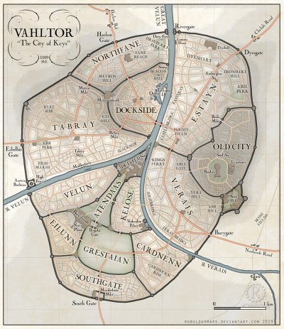
Vahltor is the capital city of Harthera (also: Vultor, Vuhltore; archaic names: Biyahl, Bahl Dorr, Buldoya). It is one of the grandest, wealthiest and most powerful cities in the world, but its surrounding walls limit the city's expansion, creating cramped streets, oppressive towers, poor housing, poverty, disease and squalor in its poorest quarters. It is colloquially known as “The City of Keys”, due to it's many gates, and because of the House of Keys, one of the chambers of Hartheran government.
Vahltorplugin-autotooltip__small plugin-autotooltip_bigVahltor
Vahltor is the capital city of Harthera (also: Vultor, Vuhltore; archaic names: Biyahl, Bahl Dorr, Buldoya). It is one of the grandest, wealthiest and most powerful cities in the world, but its surrounding walls limit the city's expansion, creating cramped streets, oppressive towers, poor housing, poverty, disease and squalor in its poorest quarters. It is colloquially known as BMEBMEHartheranHartheraHartheranHartheranHartheranHartheranHartheraHartheranHartheranHartheranHartheranHarther…
 Hover over image to see details
This is in a series of articles related to the city of Vahltorplugin-autotooltip__small plugin-autotooltip_bigVahltor
Vahltor is the capital city of Harthera (also: Vultor, Vuhltore; archaic names: Biyahl, Bahl Dorr, Buldoya). It is one of the grandest, wealthiest and most powerful cities in the world, but its surrounding walls limit the city's expansion, creating cramped streets, oppressive towers, poor housing, poverty, disease and squalor in its poorest quarters. It is colloquially known as BMEBMEHartheranHartheraHartheranHartheranHartheranHartheranHartheraHartheranHartheranHartheranHartheranHarther…, capital of the Hartheran Unionplugin-autotooltip__small plugin-autotooltip_bigHartheran Union
Formal name of the nation of Harthera..
Name
The first known settlement in the region was the ancient city of Biyahl, the spiritual capital of the Kingdom of Emanuné. The name meant “dividing place” or “where two meet”, referring to the junction of the River Velun and the River Verais. The Ensanni trade fort Bahl Dorr, “dorr” being a Thalsic word for city, indicates “imperial city at Biyahl”. Saloyans contracted this to Buldoya, which in Hartheranplugin-autotooltip__small plugin-autotooltip_bigHarthera
The Hartheran Union, commonly named Harthera, is an imperialist maritime nation state dominating the northeast of Anásthias. It is one of the two great powers of the modern epoch, arguably the most technologically and militarily powerful nation in the world, only matched by the vast size and wealth of its neighbour, viridOrorrMEOrorrOrorrOrorrOrorr times became Vultor, later Vahltor.
History
Sited at the confluence of two rivers, where the Verais flows into the Velun, throughout history the city was a crossing point between imperial powers to the east and west.
It was a religious centre from early times, the sacred centre of the Kingdom of Emanuné. The rocky promontory at the confluence of the two rivers, now the site of the Detatedn Palace - was in ancient times called the Temple Mount. According to Emanuné religion, this was the birthplace of creation, where “the yama of the Iron God descended from heaven into the spread youmee of the Mother Goddess, from which all life was born”. The Emanuné royal city lay on the hill now known as the Old City, with a grand processional route between the two sites.
In the second and first centuries BMEplugin-autotooltip__small plugin-autotooltip_bigBME (Before Modern Epoch)
Used to date years Before the Modern Epoch., the priestly kingdom became a pawn in the game of power between the Dor-en-Sann Empireplugin-autotooltip__small plugin-autotooltip_bigDor-en-Sann
The Empire of Dor-en-Sann, one of the largest multicultural empires in history. and the Grand Palatinate of Saloya.
The EnSanni gained a concession to build a trading post, Bahl Dorr, on the west bank of the river, on the site of the modern Docks. This rapidly grew into an imperial colony with its own garrison, becoming particularly important when Emanuné became a protectorate in 128 BME.
In 30 BME the Saloyans conquered Emanuné, raze much of the old imperial city. It was soon resettled, and named Buldoya. Within a century this city was in turn seized by the Junda barbarians who founded what became the modern Hartheran state.
Growth
Vuhltore can in fact be seen as three cities, as it is divided into three by the rivers. On the west bank, the EnSanni imperial garrison city Bahl Dorr was built on an ancient river bend, in a basin formed by low hills. The Saloyans and early Hartherans extended this to a fortified city, with walls atop the hills that surround this basin. Beyond this were a series of small towns and villages that were eventually enclosed with by stone walls, swallowed up by the city.
In the east was the original Emanuné city of Biyahl, built on the low domed hill now known as the Old City. It was essentially a sprawling ceremonial complex, lightly defended; a series of halls and palaces for the administration of the ancient kingdom. The Saloyans rebuilt the crumbling complex as a winter capital, housing the Palatine's court during the winter months when the upland roads were blocked by snow. The Saloyan palace-city was virtually destroyed during an earthquake that split the hill, forming the cliffs and barren rockscape further east. With its fortifications breeched the opportunistic Junda easily seized the city, and later built an impressive fortress here in what has forever after been called the Old City.
When the city government moved to the Detatedn, the old fortress was half abandoned, and turned into a mortuary temple and crematorium. For centuries the quarter was run-down, haunted and depressing, until the slum-land was cleared to build the new Basilica and University.
Last is the southern quarter. The Temple Mount was built by the early Emanune people, on a spur of rock where the rivers joined. The surrounding land was rocky and uninhabited except for isolated huts. The Saloya maintained the temple complex, but the old religion gradually decayed and the temples fell into ruin. Later, the Junda took advantage of the rock's strategic location above the landscape, and using Saloyan expertise turned the whole area into a fortress, now called the Detatedn. The fortress has been added to over the centuries, and is now a sprawling mass of walls, towers, courts and dungeons.
Between these three centres, areas of land were gradually enclosed by dykes and then by walls, eventually settling into the rough ring shape of the city today.
Internal Structure
The city is the capital of Hartheraplugin-autotooltip__small plugin-autotooltip_bigHarthera
The Hartheran Union, commonly named Harthera, is an imperialist maritime nation state dominating the northeast of Anásthias. It is one of the two great powers of the modern epoch, arguably the most technologically and militarily powerful nation in the world, only matched by the vast size and wealth of its neighbour, viridOrorrMEOrorrOrorrOrorrOrorr, and of Teloyun cordrome, the military province surrounding it. The city is heavily fortified, and as it has grown, new walls were built, so that the city is a series of walled districts. No new districts have been constructed for several centuries, though the city's districts have been internally rebuilt many times.
There are sound reasons for limiting the city's growth, bearing in mind Hartherans' logical and militaristic mindset. First and foremost is military strategy.
Urban warfare is the worst and bloodiest kind of fighting. In unwalled cities, the enemy can easily take outlying districts, using them as bases, garrisons and sniper posts, while the defender fights a street-by-street battle, often involving civilians. In case of a siege of Vahltore however, the enemy would find it difficult to take the city except by breaching it district by district. The walls would still be secure, allowing artillery fire from the walls. The walls are also a highway allowing militia to move quickly to attack and to retreat in safety. The many towers are fortresses in themselves, all very costly to take. This rationale applies equally to insurrections within the city. By keeping districts separate and the population enclosed, armed uprisings are limited to separate portions of the city.
To enforce this defensive strategy, the military government prohibits any building within two miles of the city walls, so that approaching forces will have no cover against artillery fire. This has created a curious effect as the city has expanded. The city is surrounded by a ring of sparsely inhabited farmland, around which are clusters of dormitory towns and villages, housing agricultural labourers and city workers too poor to find accommodation within the city. As time progresses these towns will undoubtedly merge into a ring of suburban sprawl, separated from the city proper by a ring of agricultural parkland.
The second reason for maintaining internal walls is fire control. By dividing the city into distinct regions, fire outbreaks (a constant scourge in any dense city) are more easy to control. Every large tower along the walls has water tanks, pumps and hoses, allowing fires within pumping distance of the tower to be controlled by a mist of water. This might not save the entire district, but it will prevent it spreading throughout the city.
The last reason is an economic one. As the city has expanded over the centuries, each successively enclosed district has had longer walls. The cost of constructing miles of heavy outer fortifications, often over difficult terrain, has become prohibitively expensive. The threat of direct invasion has also greatly decreased as Harthera's regional enemies have been crushed, so the expense of constructing new walls now seems an unnecessary extravagance.
The city has not come under external military threat for many centuries.
Administration
Each city district is administered by a Bueroch-Director (J. dyerog ). A bueroch is a military administrator, responsible for: deploying and maintaing the local militia, maintaining good order, patrolling the perimeter walls, and monitoring traffic through the internal and external gates. Bueroch offices also keep registers of births and deaths, and issue identity papers and the various passes needed to travel throughout the city. Buerochs are often retired military officials, appointed by the city governor.
Keys and travel restrictions
The Hartheran government is very security conscious, threatened internally by nationalists, and externally by Ororr and its pernicious religion. Therefore every citizen is issued with documents at birth, and transport is only permitted by license, in an attempt to control both sedition and internal migration.
This is particularly so within Vahltor, the heart of the Hartheran State. Only residents and those with permits may enter the city's internal and exteral gates without paying a toll. This is policed by use of “keys”, giving free access to various parts of the city, for a cost. Traditionally these were physical tokens with the appearance of ornate keys, with different designs depending on the level of access within the city. The lowliest citizens will only have access to their own district or neighbouring ones, and use more crude metal designs, or sometimes even passcards of pasteboard. The wealthiest will have all-access keys to the whole city, finely wrought and plated in gold. Hence the rich are called clavigers - key-holders, often with a key design unique to their household and painted on coaches and livery.
The city's two “Restricted Districts”, the Docks and Southgate, are the only exception to this. Most Hartheran cities have free districts, where merchants and travellers from outside the city, even non-Hartherans, are given a certain freedom to enter and do business. Anyone may enter and leave these areas, but they are not allowed into the city proper. Travellers are issued with temporary documents on arrival, and anyone unable to produce these proofs on demand are liable to be questioned or ejected from the city.
The Rivers
Vuhltore is formed by the two rivers, the Velun and Verais, which join here. In a strictly geographical sense the Verais flows into the Velun, because the Verais is the shorter and younger river, but thereafter it is officially the Greater Verais.
The Verais begins in the Nashant uplands far to the east, in the old Saloya heartlands. It is broad and fast-flowing, long ago carving quite a deep valley into the surrounding rock east of the city. The Velun begins in the distant Dun Jaen mountains far to the west. By the time it reaches Vuhltore it has already flowed across thousands of miles, fast flowing in the mountains, through forests and crossing the rolling plains, becoming thick with silt along the way. By the time it reaches Vuhltore it is wide and slow, meandering back and forth across rich western alluvial plains, narrowing only to pass through the hills surrounding the city. The banks of the Velun are constantly shifting, and in ancient times they were swamps, then water meadows, cultivated for crops. These meadows have long since been drained to accommodate poor housing, but the banks still flood occasionally.
Industry
Textiles - various textiles are spun and fashioned in the south, and shipped to the city where they are dyed and sold as fashion dictates. Dyesgate is a noisome district of the city, its colourful effluents polluting the lower river and clouding the sky with acrid steam. Cloth is sold to textile merchants in the cloth markets, to tailors, seamstresses and fashionable clothing shops throughout the city. Clothing production is one the city's biggest industries.
Artificing - the heavy industries of metal extraction and manufacture happen elsewhere, the refined materials being shipped to the city for fine manufacture. The city's artificers produce mechanisms particularly for the navy and military - balloon heat pumps, weapons, heating devices, compasses, timepieces and so on. Only fine artifacts are produced here; the heavy industrial production for shipping goes in where the ships are constructed, in Harlon.
Districts
West Bank
Docks
- City Quays - The ancient EnSanni garrison city of Bahl Dorr was built on a tight loop of the river. Over time the river broke through the neck of the loop, forming an island (modern Tackspur). The loop eventually silted up to form an oxbow lake. The Hartherans saw the potentional for this lake to become a perfect river harbour. The northern edge of the lake was dredged out some seven hundred years ago, and channels and quays constructed of stone. This quays are the heart of the city's modern commercial district, bustling with barges and river vessels, surrounded by warehouses, exchanges and markets.
- Tackspur - Tackspur was once a river island, now silted up at the southern end to form a low stretch of land just under a mile and a half long, but less than a quarter of a mile wide. The entire island is a military installation housing the city's naval headquarters and naval docks. At its northern tip are a series of towers and fortifications guarding the entrance to the harbour. Underwater chains allow the garrison to close off the harbour to ships in case the city is attacked, or to prevent ships leaving.
- Beacon Hill - is one of the few surviving features from Imperial times, a part of the EnSanni city of Bahl Dorr. It is an artificial mound built on an area of high ground, once topped with a keep and watch tower. Several towers have been built on the site at various times in history, including an observatory and a windmill, but it is now a signal tower keeping watch for commercial shipping, and for sending important messages throughout the city. Beacon Hill is one the most affluent parts of the Docks Quarter, its slopes covered by the houses of rich merchants - conveniently near their offices, near the signal house, and with excellent views over the river and the city.
- Barrow Sump - lies Between Beacon Hill and the Docks' north wall. It is a dank patch of land, a boggy valley shadowed by the hill and the walls beyond. It was once used as a rubbish dump and later as a slurry pit, particular after the city banned dumping human waste in the river. Today it is a slum for the very poor, living in tumbledown housing perched on its filthy slopes.
- Metrosandendt - a huge, largely modern palace rebuilt in the Hartheran Military Style, replacing the old castle with its sprawl of annexes and endless interconnected courtyards. It is the centre of Harthera's bureaucratic administration, responsible for licensing, permits, and the law. It sits atop the highest hill in the west city, and in ancient times was the chief fort in the old walls defending the port city. The eastern front has an impressive facade, providing an impressive show of Hartheran power from the dockside, but today most citizens coming to the palace for writs, permits or crimes use the western entrance in Tabray. The Metros is also the principle military and civic complex of the western city, as the local bureaucracy for all three western districts are located here. It issues all documents and passes for the West Quarter, as well as housing the local records offices and the lower law courts.
Tabray
- Ebr Park - this was once a series of animal markets
- Tabray Market -
- Metros Market -
- High Ferry -
- Aasven Barbican -
- Eihdbis Gate -
Northgate
- Harlon Gate -
- High Fane -
- Dray Ferry -
- Dray Fery Park -
South Quarter
Civic Centre
- Detatedn - the massive government palace, the hub of the entire Hartheran empire. The building is a nightmare agglomeration of towers, halls, garrisons and barracks, a brutally functional fortress which has expanded like a cancer over the centuries, swallowing up the entire rocky precipice, slowly edging southward as the river eats steadily into the cliffs at its base. The rock was once the Temple Mount of Emanuné, only of the holiest sites of the ancient world. The sanctum was demolished the the Junda, its huge blocks used to construct the earliest fortifications, now swallowed up by later additions. The main fortifications were constructed by the Chelidt Overlords, who turned the whole mount into a rocky fortress. The oldest surviving sections are in the north, but the rivers have slowly eroded the base of the cliffs, so much of the old structure has collapsed into rocks below. The northern section is dank and crumbling, seldom frequented, and the vilest dungeons of the Hartheran state are almost certainly found here. The more southerly portions is a seemingly endless series of buildings, watch towers and courtyards in a riot of conflicting architectural styles, housing the centres of civic and military government. Its halls are decorated in sumptuously brutal Hartheran military style.
- Atendaas (Longfield) - The Longfield was originally a pastural enclosure, part of the original citadel, atop a ridge of land between the two main sections of the fortress. This long walled avenue is now parkland, lined with grand hierarch palaces, military residences, governorship compounds and residences for the high commissioners of the Hartheran empire. The Longfield slopes gently downhill from the gates of the Detatedn, to the Bireilundt Palace. A wide triumphal boulevard links the two, lined with prize relics from the conquered old kingdoms of the south.
Eilunn
Eilunn was once an elite suburb in the shadow of the Bireilundt Palace, and its avenues are still lined with former grand mansions, now converted into shops apartments and tenements. Today it is mostly known as a fashionable shopping district.
Some of these mansion villas are still occupied by once-wealthy families, but most have been turned into apartments, particularly for lesser government functionaries working in the Bireilundt.
- Bireilundt - While the Detatedn uphill turns the great wheels of government, the sprawling Bireilundt Palace houses the official offices of the vast administrative bureaucracy which powers Harthera. It is a huge edifice, five storeys high in places, a vast wall of stone, pillars and triumphalist architecture fronting a rambling mass of utilitarian blocks and gloomy courtyards, where the ceaseless tidal paperwork of state flows back and forth. All important government records are kept here, and all passports, licenses and civic documentation are issued from the various high draughty halls that punctuate the building like asthmatic lungs. Ordered queues often spill out into nearby streets on busy days. It is also home to the High Courts of Justice, notoriously whimsical and inefficient law-givers.
- Navy Plaza - the Bireilundt is also home to the Admiralty, which has swallowed up the entire eastern portion of the building. Last century the government built a great spur of triumphalist architecture, dedicated to the nation's military and naval victories. This gateway divided the once bland expanse of courtyard in front of the palace in two. The western half is a sometime food market, seasonally cluttered with crowds and queues awaiting entry into the civic halls. The eastern section is now Navy Plaza, a grand square surrounded by impressive statuary, where military parades are held and grand public announcements are made from the palace balconies.
- Eilunn Boulevard - the most fashionable shopping street in the city, with former sculpted mansions converted into spacious salons and boutiques selling everything from fashionable clothing to jewellery and homewares. The most exclusive of these are at the southeast end close to the Kelose Gate, easily accessible by carriage for the wealthy residents of Cardnenn and Kelose.
- Kitroy Hall - the city's premier opera house.
Velun
This aptly-named riverside district occupies the sloping ground between the old walls of the fortress, and the shifting banks of the river Velun. It was once not properly a district at all, and was considered outside the city proper - merely a slope of flood-prone mud between the riverbank and the walls. However, as time passed the poor built hovels here, establishing grubby markets, inns and all the services of any other district. The less poor grabbed the drier ground upslope, clinging pitifully onto the city walls. The district housed the very poorest - street cleaners, dirt movers, rubbish collectors, and the thieves and whores who inevitably spill out of poverty. But gradually the district dragged itself up from the mud and today grasps toward a grubby respectability. The riverside is clustered with wooden shacks, many on stilts, with wooden streets rising above the river mud. In winter the river often floods and sometimes freezes, making streets of ice. Various attempts have been made to check the river banks, but the land is to flat and marshy, and irregular, to easily hold it in a dependable channel. Today Velun is less violent and disease-ridden than in previous centuries, when the city would lock its gates and leave fires or plague to burn itself out within the district's walls. It still houses workers for the grubbier industries (including the cheapest whore-houses), but it is mainly the source of domestic servants, who either serve in the great houses of the South Quarter, or who cross the river by ferry into the middle-class homes of Tabray.
- High Ferry - the most thriving area of Velun is near the ferry, a series of chain-linked barges that carry passengers over the river from Velun and Tabray. The ferry is the only way of crossing the river without making the long journey eastward and crossing Castlebridge, virtually circumnavigating the city. Efforts have been made to built bridges along the Velun, but the ground is too soft and the bedrock too deep to make this realistic. Highferry Road crosses district from the ferry to the gates, and it is lined with markets, cheap shops and other services.
- Undercliff - one of the quietest and most inaccessible parts of the city, Undercliff huddles under the shadow of the Detatedn Palace. It lies at the easternmost end of Velun.
Kelose
Kelose is a bowl-shaped area of land sloping up to the walls of the Detatedn fortress, and down to the cliff banks of the river. It was once an arable enclosure with livestock and fields of food crops, with granaries and all the minor industries to service the old fortress. It was protected by walls on one side and steep slopes falling down to the river on the other. As the fortress evolved from a military stronghold into a government complex, the richer hierarchs and powerful families took land here to build grand houses, nestled against the safety of the fortress walls.
Today the district is a graceful enclosure, the higher northern side a wealthy district of parks and gardens. The southern end is clustered with neat streets, genteel shops and well-ordered markets, serving all the needs of the great houses nearby. Along the river are newer mansions of the wealthy, with steps down to their own private landings.
- Kelose Gardens - two hundred years ago local authorities took the decision to restrict any further building toward the centre of the enclosure, which would block air and views for the mansions already built. Instead the inner area was turned into garden, landscaped by prominent artisans of the day, containing perfumed flower-beds, trees and genteel promenades. It is crossed by a single road, that carries traffic east and west, from Atendaas to Highbridge.
- Vodrodim Palace - this was the site of an ancient castle, originally built as a sumptuous residence for the powerful Saloyan Vodroy family, later rebuilt as the eastern gatehouse of the old fortress city. It defended the end of the Vodrod Bridge, long since collapsed. The palace has been frequently rebuilt over the ages and is now the residence of the District Bueroch. It has an extensive inner quay, used by important hierarchs for transportation by ship up and down the river.
- High Bridge - After the collapse of the Vodrod Bridge, the residents of the increasingly wealthy Kelose district resented travelling south to the Terat Bridge, having to cross the river with the dray-carts and common foot traffic. Efforts were made to reconstruct the Vodrod Bridge, but the bridge had collapsed because of fractured bedrock on one side. Moreover, the Palace was now residence of the local Bueroch, who resented the prospect of having constant traffic passing beneath his windows. Eventually a site was found between two outcroppings of solid rock, in a narrowing where two buttresses of rock thrust out high above the river. Highbridge was a marvel of contemporary engineering, an elegant single-span arched bridge made of iron chains faced with stone. The bridge has weight limits and is only able to carry light carriages and foot traffic. Subsequently it is restricted to official vehicles and local residents, who require a special permit.
Grestaian
Grestaian Park - this vast parkland was once an important military staging area, for martialing troops against a city invasion. Today it is a vast area of parkland and gardens, crossed by important highways that carry traffic across the city. Building is prohibited within the district, except for facilities. It is the largest area for public recreation in the city, used for fairs on public holidays, for mass state celebrations, and most famously for games and races. The most important is the annual Grestaia Chase.
Cardnenn
Cardnenn is largely a genteel residential district, with rows of neat houses surrounding a low hill called Cardnenn Rise. The northern portion nearer the river has the main cross-city road, leading between Grestaian and the Terat Bridge. The bridge is the only real connection for goods and heavy traffic between the South Quarter and the rest of the city - Highbridge being limited to light local traffic, and the only link to the west being the Velun ferry. Along the road and near the bridge are various markets and shops, primarily serving the local area, particularly draperies, laundries, tailors and domestic suppliers.
- Cardnenn Rise - a low circular hill in the south, its feet are surrounded by the district's walls, but its heights are ringed by streets of neat middle-class houses.
- Odratenedn Palace - Not so much a palace as an extension of the tower fort overlooking the river, this rather grimly functional outpost serves as the administrative offices of the district, as well as the headquarters of the river watch, who patrol the river in boats moored on the rivergate wharf.
- Terat Bridge - the second oldest bridge in the city, and the oldest surviving, it was first built over a millennium ago and still is a vital link. It is the only bridge carrying goods traffic into the South Quarter, the only option for travellers going to Tabray is to take the ferry, or travel the long way round by the Terat Bridge. It is a bustling area with thriving markets, and one of the most important shopping areas in the city.
Southgate
Southgate is poor, cramped in the dip between two parallel curtain walls that once formed the outer ramparts of the city. It is one of the city's Restricted Districts: foreigners, refugees and visitors to the city can stay here temporarily, in one of the many cramped and foul-smelling hostelries that line the streets. It lies just inside the city's southern gate so is a district of markets - fruit, vegetables, livestock, flowers and every item of local produce can be bought here. It also has extensive flea markets, where migrants sell their treasured possessions for cash. An endless variety of items can be found, legal and illegal, from all over the world, on the quarter's cramped rambling streets.
- Murderhole Market - Inside the great barbican of Southgate is a huge stone yard. It was built for marshalling troops, but primarily as a trap for invading forces. If the outer city gate was breached, marauding soldiers would spill into this yard, which is surrounded by ballista towers and hundreds of arrow slits. The only exits are through a series of smaller gates on the north side. Today the yard is a bustling market for local produce. Farmers from outlying villages sell their wares here, without needing to venture further into the city, or the perils of Southgate. Indeed farmers seldom have leave to enter the city at all. Curiously this is one of the only areas in the city where free assembly is permitted, and there is a great tradition of preaching and lambasting. Speakers stand on the old Pillory Stones in the northeast corner, haranguing the crowd on whatever topic is in their mind. The city government permits this outlet here, partly because should trouble arise, the yard is easily secured against rioting.
East Bank
Verais
- Highbridge -
- Terat Bridge -
- Bury Gate -
Estayn
Estayn is the city's industrial sector, specialising in prestige manufacturing of finished and semi-finished goods, particularly ceramics, glassware and dyed cloth.
- Eastquay is a local wharf exclusively for the district's industry, shipping finished materials across the river and downriver, and importing and storing raw materials such as raw cloth, minerals and dyestuff.
- Castlebridge is the most important link between the east and west cities. The bridge is a huge ancient structure, built from heavy stone blocks blackened with age and grime. The deck of the bridge is wide enough for wagons to pass each other in each direction, with hawkers and market stalls lining the balustrade. Castlebridge is also famous for its fresh river fish, purchased by lowering baskets over the side of the bridge to fishermen whose small boats crowd the water. Castlebridge is so named for its two forts of four square towers on each side of the river, tall, thick-walled constructions built to protect the vital bridge from military assault. Today only the entrance towers on each side are used by the military, the other remaining six being hostelries, and gaming houses with a shady and exciting reputation. Being between Estayn and Dockside, Castlebridge has been legally defined as outside the city, so enforcement of the law is considered slacker here than elsewhere. After the bridge closes each night, it becomes a night market for revellers, who are trapped on the bridge until dawn, although in practice those who've had too much are lowered to waiting boats below, taking their chances with night ferrymen.
- Brok Market prospered during the Commonwealth period when the old kings banned street markets from the Citadel. Today it is a sprawling flea-market for second-hand clothes, books trinkets and general bric-a-brac, a place where the genteel poor go to sell their possessions, and where students and opportunists browse for a bargain.
- Abil Park is a picturesque but unkempt area of gardens wedged into a sloping corner between Estayn and the Citadel. It was once the gardens of a prosperous clothing merchant whose house was destroyed in a fire, leaving the gardens behind. Today they are a favourite retreat of city workers who climb the hill to admire the view, and eat and drink in the kiosks there.
- Dyesgate is the main foot gate north of the city. In former times this was dominated by the Dyesmarket, where raw materials were brought into the city by cart and sold to manufacturers in the lower district. Today most raw material is brought in bulk by river. Dyesgate Market today is now more of a market for local farms. To the west are streets of once grand merchants houses, now almost all tenements for local workers, with the factories located alongside the river.
Old City
The Old City surrounds “Holy Hill”, the highest point in the city surmounted by the domed Basilica of Holy Hart. It has been an important site for millennia, first as a hill fort, then as the palace of the kings of Emanuné, and later the Winter Palace of the Palatines of Saloya. During the Hartheran Commonwealth the kings built a new Citadel here, surrounded by strong graceful walls of buttery stone, dominated by the King's Palace and the dome of the Basilica. Since the downfall of the Commonwealth the Citadel declined into a reserve for students at the University and prelates of the church.
- Palace Greenplugin-autotooltip__small plugin-autotooltip_bigGreen
The Green Kingdom of flora and fauna includes humans, mammals, birds, whales, greenfish, and most green plants and crops cultivated by humankind. is a greenplugin-autotooltip__small plugin-autotooltip_bigGreen
The Green Kingdom of flora and fauna includes humans, mammals, birds, whales, greenfish, and most green plants and crops cultivated by humankind. open space in the southern part of the Old City, with memorial gardens and pleasure gardens for contemplation. In Commonwealth times it was ringed by grand palaces of the nobility, but these are now either private homes, student tenements or otherwise used by the university. - Basilica of Holy Hart - the great Basilica sits on a hill in the middle of Palace Green. It is the centre of the Church of Hartrah, the most important site for all national rituals and celebrations.
- University - The City University occupies the former palace of the kings of the Commonwealth period. It is the foremost centre of education for the national elite.
- Bone Hill is the common name for the Old Citadel, built by the early Chelidt Overlords but later abandoned due to its uncertain foundations. Today it serves as city's crematorium and ossuary, with grey smoke continuously pouring from its grim crumbling towers.
- Bone Fields lies below the Old Citadel, outside the city. Citizens commonly scatter ashes of their loved ones from the Citadel walls, leaving the ground scattered with bone fragments. The very poorest dump bodies here, or bury them in shallow graves at night.