Table of Contents
Atlas: Azri Isles
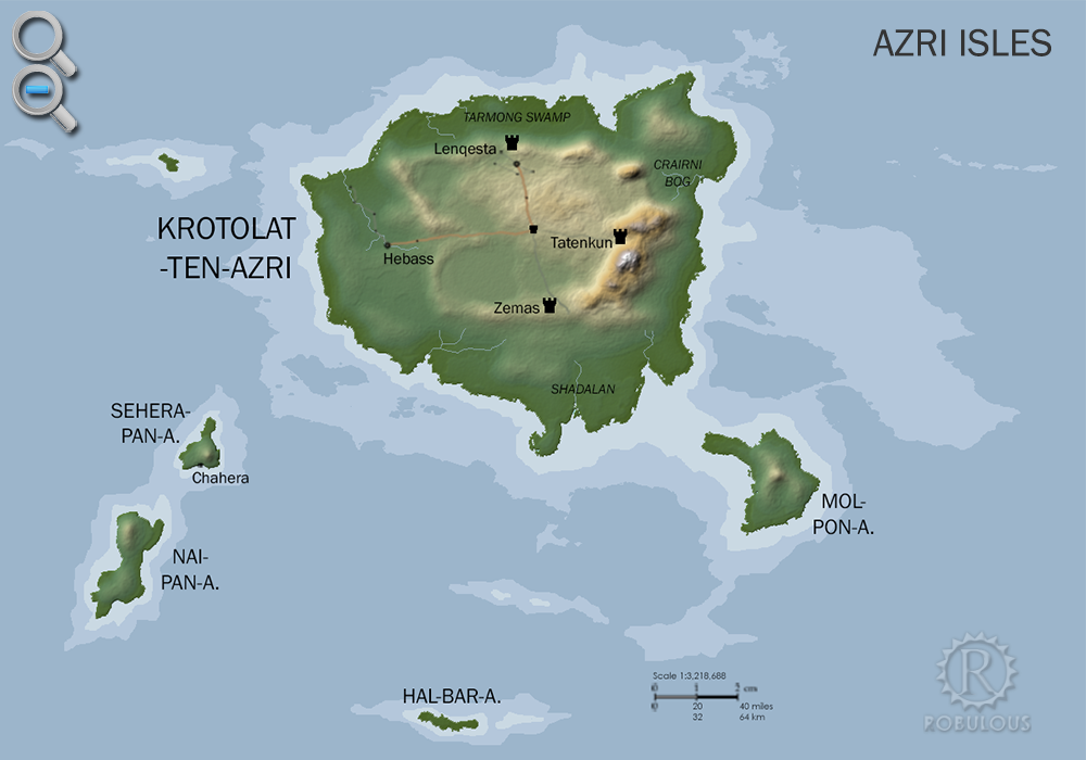
Azri Isles
The Azri Isles are a group of volcanic islands in the cool southerly seas of the Great Urash Oceanplugin-autotooltip__small plugin-autotooltip_bigGreat Urash Ocean
The Great Urash Ocean is one of the four oceans surrounding the Civilised World. It's name derives from the Manthi word meaning southern.
It extends south from Anásthias to the Icehorns of the south pole, and from Vulime in the east to Zahkdarret in the west. Its boundaries are somewhat vague, as its seas are not often travelled by ships from the Anásthias, at a latitude of 54°S, over 3000 km south of Anásthiasplugin-autotooltip__small plugin-autotooltip_bigAnásthias
Anásthias [a-NAS-thee-ass / ænæsθiːæs], or [an-ass-THEE-as] is an equatorial island continent, heart of the Civilised World. The north straddles the equator and is hot and humid, while most of the equatorial centre is an upland plateau with fertile river valleys, and stretches of arid plains and desert in the shadow of the mountains. The south is temperate but more wild, separated from the civilisations of the north by the almost impassable Harthera. By far the largest is Krotolat-ten-azri, followed by Mol-pon-azri, Nai-pan-azri, Sehera-pan-azri and Hal-bar-azri, in descending order of size, plus hundreds of smaller islands which are mostly uninhabited.
 plugin-autotooltip__small plugin-autotooltip_bigAtlas: Azri Isles
[fmap-azri_isles.png] * Zoom in * Zoom out
Azri Isles
The Azri Isles are a group of volcanic islands in the cool southerly seas of the Great Urash Ocean, at a latitude of 54°S, over 3000 km south of Anásthias. By far the largest is Krotolat-ten-azri, followed by Mol-pon-azri, Nai-pan-azri, Sehera-pan-azriAnásthiasgreenviridgreenviridgreen
The islands were settled in prehistory but have remained isolated from the rest of the Civilised Worldplugin-autotooltip__small plugin-autotooltip_bigCivilised World
The Civilised World refers to the known regions of human civilisation, notably the continent of Anásthias, the Natorn Archipelago and surrounding islands.
Gastrinimer's 3rd century BME Map of the World, showing Anásthias and the Natorn Isles. Note: old maps place north to the right.AnásthiasAnásthiasAnásthiasAnásthias for thousands of years. Consequently their languageplugin-autotooltip__small plugin-autotooltip_bigLanguages
List of human languages and dialects, contemporary and extinct.
Language
language
This is in a series of articles about Languages and Communication.
topics sidebar cult1 and culture are entirely separate from those in Anásthias.
Geography
The islands sit on a volcanic bulge rising steeply out of the deep oceanic plain. All the major islands show a history of volcanic activity, though most have been dormant in recent history. All of the main islands also have inland cliffs, suggesting that the island chain is slowly rising from the sea.
Krotolat is the largest island, 240 km wide and 350 north-south, bigger than all the others combined. The island's centre consists of a arid central plateau with volcanic mountains to the southeast. The northern and southern lowlands are marginal land subject to tidal flooding. The west of the island is sheltered and has the densest area of population and cultivation in its greenplugin-autotooltip__small plugin-autotooltip_bigGreen
The Green Kingdom of flora and fauna includes humans, mammals, birds, whales, greenfish, and most green plants and crops cultivated by humankind.-forested valleys.
Due to their far southerly latitude of 54°S the climate is cool and wet, winters being particularly cold in the southern uplands during winter. However, extensive vulcanism and warm sea currents from the tropics making the islands temperate and extremely fertile, particularly in the lowlands.
The inhabited islands have a majority of greenplugin-autotooltip__small plugin-autotooltip_bigGreen
The Green Kingdom of flora and fauna includes humans, mammals, birds, whales, greenfish, and most green plants and crops cultivated by humankind. plantlife, with many species unique to the islands. It is speculated that the first human colonists arrived in the aftermath of volcanic eruptions when the soil was new and bare, enabling them to colonise Krotolat with a diversity of green plants, many not found in the rest of the Civilised Worldplugin-autotooltip__small plugin-autotooltip_bigCivilised World
The Civilised World refers to the known regions of human civilisation, notably the continent of Anásthias, the Natorn Archipelago and surrounding islands.
Gastrinimer's 3rd century BME Map of the World, showing Anásthias and the Natorn Isles. Note: old maps place north to the right.AnásthiasAnásthiasAnásthiasAnásthias.
History
Krotolat-ten-Azri experienced two waves of human settlement, the first in the ancient past, most likely during the Celadon Epochplugin-autotooltip__small plugin-autotooltip_bigCeladon Epoch
Name for the period of history c.6200-3000 BME, also called the Age of Miyarris, after the foremost civilisation of that era. around 5000 BMEplugin-autotooltip__small plugin-autotooltip_bigBME (Before Modern Epoch)
Used to date years Before the Modern Epoch.. This indigenous population cultivated the larger islands, developing a unique form of rock polyculture, with food and medicinal plants grown together forming sheltered microclimates.
This indigenous culture persisted for millennia, until the coming of more advanced settlers to Krotolat around 800 BMEplugin-autotooltip__small plugin-autotooltip_bigBME (Before Modern Epoch)
Used to date years Before the Modern Epoch.. These were likely Eloyounplugin-autotooltip__small plugin-autotooltip_bigEloyoun People
The Eloyoun people are an ethnic group found throughout eastern and northeastern Anásthias. They are the majority ethnicity in Kahtoyn and most of southern Harthera. Modern Hartheran language and culture is a blend of Eloyoun and Iskean.
The Eloyoun people claim descent from the ancient realm of Harthera descendants of Miyarrisplugin-autotooltip__small plugin-autotooltip_bigMiyarris
Miyarris [mee-YA-riss], (also Miarris, from Mayápo Mayarous) was a hugely influential ancient civilisation located which flourished during the Celadon Epoch, from 4000-3000 BME. It is considered the first great civilisation in history since the the mythic Godmen.
Ancient Miyarris
BMElanguagelanguagelanguageAnásthiasEloyounlanguagelanguagelanguage, who brought new plants and seeds, new technologies, and quickly established cities with stone architecture and complex social hierarchies. Their new agricultural system drained the swamps and slashed and burned the viridplugin-autotooltip__small plugin-autotooltip_bigVirid
Referring to the Virid Kingdom of flora and fauna, toxic to human life. inland forests, turning them into fields and pastures that hugely boosted the food supply, enabling a much larger population. Centuries of this intensive agriculture soon depleted and eroded the once rich soils, turning the inland of Krotolat into desert, and leading to war, famine, and total collapse of the urban kingdoms.
Culture
Lenqesta in the north was a thriving and highly developed city, supported by a huge area of farmland. After the great decline it was abandoned and is now largely ruined, its farmlands now the Tarmong Swamp, contaminated with salt and virid weed. Tatenkun in the east sits in the shadow of the volcanoes, once made rich by mines and quarries, long since collapsed. Zemas to the south remains as a small city, the centre of the island's philosophic mystery religion. Hebass in the west is the largest city today, surrounded by green woodland and farms.
Myth
The main historical myth of the Krotolat is the Tale of the Four Brothersplugin-autotooltip__small plugin-autotooltip_bigTale of the Four Brothers
The Tale of the Four Brothers is work of folklore or oral history from the island of Krotolat-ten-Azri, largest of the Azri Isles. It is likely an allegory of actual historical events, when more advanced settlers from the mainland arrived in the Beryl Epoch, though with few written records the real history is unknown., first transcribed by a traveller from Sjilplugin-autotooltip__small plugin-autotooltip_bigSjil (Seldan)
Sjil, known as Seldan in much of the Civilised World, is a famous trading city in Schai-dam, historically the greatest and most famous trading port in Munatan.
Its remoteness from the northern “Civilised World”, the rarity of its goods and the novelty of its tales and ideas led to it being a fashionable topic for writers of romantic and adventurous fiction in 9th century in the 10th century. It describes how four god-like sorceror kings divided the land between each other, but eventually fell into strife and ruin. The tale is believed literally by many inhabitants, but the few writers who have visited the island interpreted it allegorically, probably explaining an environmental disaster which devastated the islands. The centre of the island is a lifeless plain which most likely was denuded of virid forest, but in which green life collapsed due to poor farming techniques and soil erosion. This almost inevitably would have led to starvation and violence.