Atlas: Civilised World
Civilised World
The Civilised World refers to the known regions of human civilisation, notably the continent of Anásthiasplugin-autotooltip__small plugin-autotooltip_bigAnásthias
Anásthias [a-NAS-thee-ass / ænæsθiːæs], or [an-ass-THEE-as] is an equatorial island continent, heart of the Civilised World. The north straddles the equator and is hot and humid, while most of the equatorial centre is an upland plateau with fertile river valleys, and stretches of arid plains and desert in the shadow of the mountains. The south is temperate but more wild, separated from the civilisations of the north by the almost impassable Harthera, the Natorn Archipelagoplugin-autotooltip__small plugin-autotooltip_bigNatorn Archipelago
The Natorn Archipelago, or the Natorn Isles [nah-TORN], is a chain of islands in the Natorn Sea. The islands are oceanic ridge running from the northeastern tip of Anásthias to the Anrel Isles. The ridge is an active geological fault, many of the islands being volcanic.Anásthias and surrounding islands.
 Gastrinimer's 3rd century BMEplugin-autotooltip__small plugin-autotooltip_bigBME (Before Modern Epoch)
Used to date years Before the Modern Epoch. Map of the World, showing Anásthias and the Natorn Isles. Note: old maps place north to the right.
 9th century MEplugin-autotooltip__small plugin-autotooltip_bigModern Epoch (ME)
The Modern Calendar is a dating system acknowledged throughout the Civilised World. It numbers years from the Modern Epoch, abbreviated ME and BME (Before Modern Epoch). It is also called the Modern Era.
Calendar
This is in a series of articles about calendars and dating systems.OrorrHartheraHMOrorrHartheraOrorrOrorrHMHartheraHMHartheraOrorr map of the world, showing the Civilised World and the Obverse

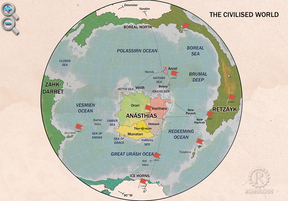
Physical map of the Civilised World
Shape of the World
All modern societies acknowledge the worldplugin-autotooltip__small plugin-autotooltip_bigHelevos
Helevos (also known as Vos, or Veeos) is a temperate terrestrial world, fourth planet of the star Cordes in the Cronox binary star system. The stars Cordes and Arjos are distant binaries, so on Helevos, Arjos is only seen in the northern hemisphere as star, sometimes bright enough to be seen during the day, circling roughly over the viridgreenAnásthiasAnásthiasAnásthiasgreen as a sphere, spinning around the sun. Astronomers and philosophers have even calculated the size of the world to a relatively accurate degree.
According to contemporary thought the world has two hemispheres, called the “two circles of the world”, which are opposites to each other in nature. The Civilised World occupies one half of the world, with the continent of Anásthias at its centre, surrounded by a huge circular sea. The far hemisphere is believed to be almost completely dry land, with a salty, dead sea at its centre, the Sea of Tears. (This idea may be derived from Dromeismplugin-autotooltip__small plugin-autotooltip_bigDromeism
Dromeism is a system of thought originating in Munatan during the Beryl Epoch, around 2000 BME. It encompasses all aspects of thought, from the fundamental nature of reality and the natural sciences, to principles of ethical behaviour and political responsibility. In its ideas about the fundamental nature of the universe, it shares some concepts with the Miyarrain philosophy of the, in which the world is represented as a sphere, one half black with a circle at it's centre, one half white with a black spot at its centre.)
The Civilised World is dominated by humans and greenplugin-autotooltip__small plugin-autotooltip_bigGreen
The Green Kingdom of flora and fauna includes humans, mammals, birds, whales, greenfish, and most green plants and crops cultivated by humankind. life, surrounded by the four oceans, the Polassirn Oceanplugin-autotooltip__small plugin-autotooltip_bigPolassirn Ocean
The Polassirn Ocean is the most northerly of the four oceans surrounding the Civilised World. The ocean is deep and cold, with occasional sea ice on the far northern shores.
It is rich with virid sea life. The shallow waters around the Natorn Archipelago are full of green fish and pelagic flora, as well as, the Redeeming Oceanplugin-autotooltip__small plugin-autotooltip_bigRedeeming Ocean
The Redeeming Ocean, historically known by it's Miyarrain name, the Poomué, separates the Civilised World from the eastern continent of Retzayk. It is 4500km across at its narrowest point. It has a number of small islands, the Eastern Isles being the only sizeable group., the Great Urash Oceanplugin-autotooltip__small plugin-autotooltip_bigGreat Urash Ocean
The Great Urash Ocean is one of the four oceans surrounding the Civilised World. It's name derives from the Manthi word meaning southern.
It extends south from Anásthias to the Icehorns of the south pole, and from Vulime in the east to Zahkdarret in the west. Its boundaries are somewhat vague, as its seas are not often travelled by ships from the Anásthias and the Vesmien Oceanplugin-autotooltip__small plugin-autotooltip_bigVesmien Ocean
The Vesmien Ocean is one of the four oceans surrounding the Civilised World, to the west of Anásthias. It extends as far north as Cape Cadal, and as far as Deshee Point in Veedormim in the south.
The Vesmien is shallower than other oceans, a notable feature being the many reefs and shifting sand bars which present a hazard to shipping. Principle amongst these are the. To the people of Ororrplugin-autotooltip__small plugin-autotooltip_bigOrorr
Ororr [o-ROARR, ɒ̝rɔ'ɾ], also called the Holy Motherland of Ororr, is a theocratic nation in Anásthias, one of the world's great powers. It the largest nation in the world, perhaps the largest empire in history, occupying the entire northwest of the continent between the mountains and the sea. languagelanguagelanguage and the religion of Therismplugin-autotooltip__small plugin-autotooltip_bigMother Church of Ororr (Therism)
The Mother Church is the state religion of Ororr, which combines both religion and government in one institution. It is based on the teachings of the Great Prophet Therion, who in the early decades of the modern era raised an army that conquered much of northwestern OrorrOrorrOrorrOrorrOrorrMEMEOrorrMEMEOrorrOrorrHerHerHerHerHerHerHerHerHerher, the shrine at Foratunaplugin-autotooltip__small plugin-autotooltip_bigForatuna
The Sanctuary of Foratuna [Fo-Rah-Too-Nah] is the holiest site of the Mother Church of Ororr: the desert place where the Great Prophet built his sanctuary tower, in which he formulated the principles of the new religion, and laid the foundations for the Ororran state.
The Sanctuary is a complex of religious buildings and housing for the priesthood, including a great hall and holy circle or greenmagicmagic is believed to be the centre of the world.
There has been no exploration of the far hemisphere, but it is believed to be almost completely dry land, choked with impenetrable viridplugin-autotooltip__small plugin-autotooltip_bigVirid
Referring to the Virid Kingdom of flora and fauna, toxic to human life. jungle and terrifying beasts, entirely hostile to mankind, dotted with lakes and seas just as the Civilised World is dotted with islands.
In modern maps therefore, the Civilised World is depicted as a roughly circular sea, with Anásthias at its centre. Surrounding the sea are the Edge Landsplugin-autotooltip__small plugin-autotooltip_bigEdge Lands
The Edge Lands are the mytho-geographic lands, said to lie beyond the four oceans surrounding the Civilised World.
They were named by the ancient Miyarrain. Zahkdarret lies to the west of Anásthias, and Retzayk to the east. The cold north is called the Icerealm, the south being the Icehorns.
These names are used in official maps and academic works, but little used in everyday speech., the distant, treacherous and utterly inhospitable places at the edge of the world. This depiction of the world's geography is crudely accurate, but there are in fact two as-yet undiscovered channels which allow passage to the farther regions of the world. Also, Anásthias is not as distant from the “Edge Lands” as currently believed.
Exploration
There are few accounts of historic attempts to explore the Edge Lands, and most expeditions to their distant shores have resulted in disaster or been utterly lost.
In ancient times the Miyarrainplugin-autotooltip__small plugin-autotooltip_bigMiyarrain People
The Miyarrain were the inhabitants of ancient Miyarris, famed as the most advanced civilisation of the Celadon Epoch. The Miyarrain were the progenitors of all modern Eloyoun peoples throughout eastern Anásthias.
Ancient Miyarris
This is in a series of articles about the ancient civilisation of language are known to have travelled to and named Vuliméplugin-autotooltip__small plugin-autotooltip_bigVulimé
Vulimé, or Voulimay (in Mayápo), is an island continent far to the south and east of Anásthias, more than 10,000km distant. The continent stretches 8400km from 25°S to 75°S , from subtropical forest in the north to icey tundra in the south.
vulime
Geologically it was once connected to, the island continent to the far southeast of Anásthias, although their reasons for visiting are long lost. The mythic realm of Orodienplugin-autotooltip__small plugin-autotooltip_bigOrodien
Orodien [o-ROD-ee-en] was the mythical second realm of the Godmen, founded during the Jade Epoch after the destruction of the first realm of Yendim. The Orodien Peninsula in the north of the continent of Retzayk is named for the mythic realm, though whether this was the actual location, or even if the mythical Orodien existed, is uncertain.viridGodmen, mentioned in the Tirennionplugin-autotooltip__small plugin-autotooltip_bigThe Tirennion
The Tirennion is an epic saga which outlines the legendary history and origins of humanity, from the creation of the universe, the mutual destruction of the ancient first gods who created mankind, and the descent of the Godmen to the world, from whom all mankind is descended. The work is most known in the, is believed to have been founded on a peninsula of Retzaykplugin-autotooltip__small plugin-autotooltip_bigRetzayk
Retzayk is a long, narrow continent approximately 4500 km east of Anásthias, separated from it by the Redeeming Ocean. It extends from the North Pole, crossing the equator and deep into the southern hemisphere.
retzayk
Eastern continent of Retzayk
According to contemporary geography, Retzayk is believed to be one of the Anásthiasviridviridvirid to the northeast of Anrelplugin-autotooltip__small plugin-autotooltip_bigAnrel Isles
Anrel [ANN-rel], or the Anrel Isles, is the most northerly island group in the Natorn Archipelago. It consists of three major islands and numerous smaller ones. The largest, colloquially if infrequently called Mainland, is divided between the kingdoms of Trésard and Narette. The island, at the boundary between ice and forest. The doom and downfall of Orodien has long served as a cautionary tale against any attempts to settle the Edge Lands.
The famed explorer Aego Gastrinimerplugin-autotooltip__small plugin-autotooltip_bigAego Gastrinimer
Aego Gastrinimer (c. 311-254 BME), was a renowned navigator, explorer, merchantman, privateer and prestigious Cartographer-Royal to the Court of Sann'al. He produced the first great world map of the modern era, based on his supposed circumnavigation of the continent of AnásthiasBMEAnásthiasAnásthiasMEAnásthiasAnrelAnásthias claimed to have been the first navigator, certainly the first in modern times, to have circumnavigated the Civilised World (a distance of over 25,000 km) and mapped it. He also made claims to have visited the Edge Lands, including the Icehornsplugin-autotooltip__small plugin-autotooltip_bigIcehorns
Part of the coastline of the South Pole continent. of the far south. Although modern historians discount this as highly unlikely, the outline used on modern maps is based on his design.
The most recent expedition was by Hartheranplugin-autotooltip__small plugin-autotooltip_bigHarthera
The Hartheran Union, commonly named Harthera, is an imperialist maritime nation state dominating the northeast of Anásthias. It is one of the two great powers of the modern epoch, arguably the most technologically and militarily powerful nation in the world, only matched by the vast size and wealth of its neighbour, viridOrorrMEOrorrOrorrOrorrOrorr mariners, attempting to explore eastward from the Eastern Islesplugin-autotooltip__small plugin-autotooltip_bigEastern Isles (New Perech)
The Eastern Isles, also called New Perech or the Spice Islands, are a tropical island group in the Redeeming Ocean at 13ºS, 3300 km from the mainland of Harthera, 4125 km from the port of Narillin. The islands have a highly diverse population of virid plant species, several of which are prized as flavourings or HartheranHartheranHartheranHartheranHartheraHartheran. The expedition made a lucky landfall on a bleak desert area of Retzayk, where they were able to take on clean water, but finding no edible food or safe harbour, they were forced to retreat to the Eastern Isles, arriving back disheartened and starved.