Sopeq
Sopeq is a prosperous city on the River Wiyel in Ororr, about 100 km north of Seqal. Sopeq was founded as one of the northernmost colonies of the Kingdom of Seqal, but has long eclipsed its ancient progenitor. Though Sopeq is much larger, for historic reasons Seqal remains the official capital of the province. In the EnSanni period there was considerable rivalry between the two cities, but Sopeq is now considerably larger and more prosperous.
Ororrplugin-autotooltip__small plugin-autotooltip_bigOrorr (Category)
Articles related to the Anasthian nation of Ororr.
[Ororr]
Regions
Provinces
Cities
Beliefs
People
Ethnic groups
topics nati1
This is in a series of articles on the modern nation-station of Ororrplugin-autotooltip__small plugin-autotooltip_bigOrorr
Ororr [o-ROARR, ɒ̝rɔ'ɾ], also called the Holy Motherland of Ororr, is a theocratic nation in Anásthias, one of the world's great powers. It the largest nation in the world, perhaps the largest empire in history, occupying the entire northwest of the continent between the mountains and the sea. Ororrlanguagelanguagelanguage.

Hover to magnify | Go to world mapplugin-autotooltip__small plugin-autotooltip_bigAtlas: Ororr
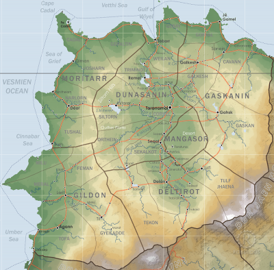
[fmap-ororr.png] * Zoom out * Gildon * Moritarr * Deltirot * Dunasanin * Gaskanin * Mangasor * @ * @
Political | Geography
atlas nationmaps
Ororr
Ororr [o-ROARR, ɒ̝rɔ'ɾ], also called the Holy Motherland of Ororr, is a theocratic nation in Anásthias, one of the world's great powers. It the largest nation in the world, perhaps the largest empire in history, occupying the entire northwest of the continent between the mountains and the sea. languagelanguagel…
- Name: Holy Motherland of Ororr
- Government: Theocratic Republic
- Capital: Torroramaiplugin-autotooltip__small plugin-autotooltip_bigTorroramâi
Torroramâi (also Tororr, T'amai, [tɔ-ROR-ah-MAH-ee, or simply “The Capital”) is the administrative and religious capital of the modern nation-state of Ororr.
Torroramai
This is in a series of articles about Torroramai, capital city of the nation of Ororr.viridviridOrorrOrorrviridviridgreenvirid - Foundation: 52 MEplugin-autotooltip__small plugin-autotooltip_bigME
ME is short for Modern Epoch, the modern method of numbering years. (Official) - Demonym: Ororran
- Language: Dorounplugin-autotooltip__small plugin-autotooltip_bigDoroun language
Doroun [doh-ROON, dɒ'ruːn] is the common language of Ororr, the principle language of law, trade, government and the Mother Church.
Language
language
This is in a series of articles about Languages and Communication.
Doroun is spoken as a first language in the regions of Dunasanin and Gaskanin, and as a second language in other regions. It developed from the languagelanguagelanguageOrorrlanguagelanguagelanguagelanguagelanguagelanguagelanguagelanguagelanguagelanguagelanguage… (official), regional languages - Religion: Mother Church of Ororr (Therism)plugin-autotooltip__small plugin-autotooltip_bigMother Church of Ororr (Therism)
The Mother Church is the state religion of Ororr, which combines both religion and government in one institution. It is based on the teachings of the Great Prophet Therion, who in the early decades of the modern era raised an army that conquered much of northwestern OrorrOrorrOrorrOrorrOrorrMEMEOrorrMEMEOrorrOrorrHerHerHerHerHerHerHerHerHerher
Etymology
Sopeq is a contraction of “wet place” in the ancient Issithai dialect of the region, referring to the marshy bend of the river.
Geography
Sopeq lies on the western banks of the river, sitting in a half-bowl of land cut out of the canyon wall. The main city has spread along the banks of the river and inland, while the entire hinterland is dedicated to agriculture, with the land rising in terraced steps up to the level of the plateau above. The canyon-top has a string of historic fortifications guarding the approaches to the city, dating back to ancient times.
History
The city's landscape was formed thousands of years ago when the river undercut the steep walls of the Kalkot Gorge. The walls collapsed in a huge landslip, forming a barrier of rock and scree in the river. With the flow blocked, the water cut into the eastern bank, forming a bow in the river which surrounds the centre of the modern city. The slope behind was further eroded by wind and occasional rainfall, creating the characteristic bowl shape.
Though a strategic location for a Seqali colony, the settlement had little resources in the landscape of desert and marsh, so remained small.
Agriculture
Various attempts at agriculture were made using canals to draw water from the river, but it was the invention of windpumps that spurred development of the city. A network of underground cisterns was cut into the riverside rock, continuously filled by pumping water from the river below. Terraces were dug into the surrounding hills, with the terraces regularly irrigated by cistern water. Water needed to be strictly controlled and rationed, so a strong central authority emerged, with a system of laws and arbitration. Being able to grow and export its own food, the city grew to its current state of prosperity. Today it is the economic hub of the Kalkot Gorge, supplying not only essential food to most nearby cities, but manufactured goods like rope, bricks, linen cloth, and building ships with imported wood.
