Atlas: Duospherical world
World of Helevos as seen by contemporary cartographers
< Physical world mapplugin-autotooltip__small plugin-autotooltip_bigAtlas: Helevos interactive map
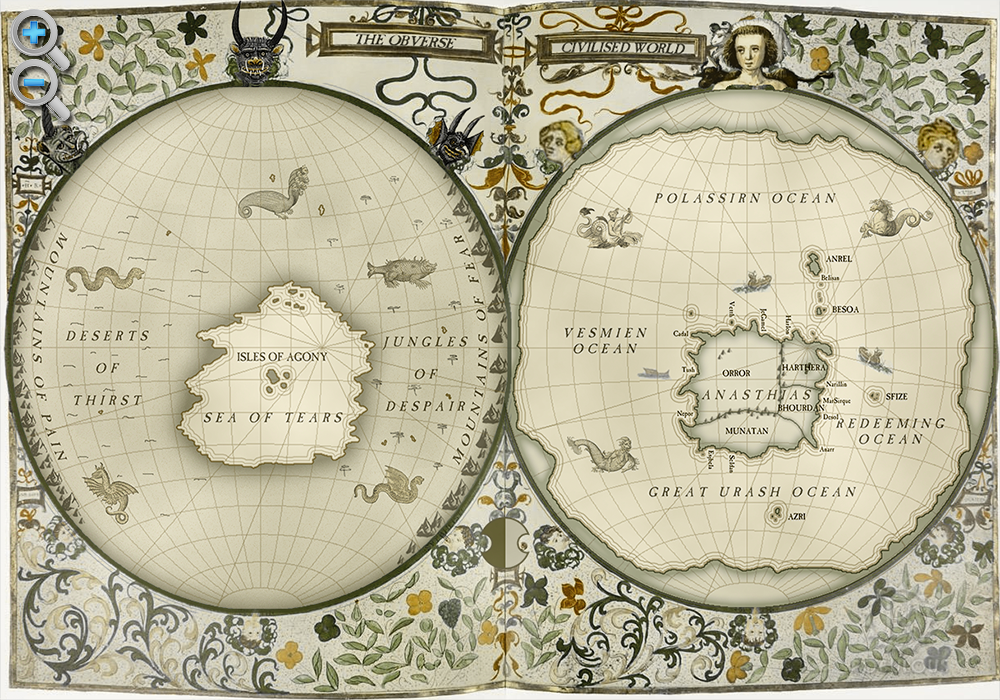
[fmap-hemispheres.png] * Zoom in * Zoom out * Planets * Moons * North Pole * South Pole * The Obverse * The Civilised World
Physical/Political map of Helevos. Click red flags to zoom in, or nav buttons to zoom out
< Historical world map
atlas
Helevos
Helevos (also known as Vos, or Veeos) is a temperate terrestrial world, fourth planet of the star Cordes in the viridgreenAnásthiasAnásthiasAnásthiasgreen
Duospherical Theory
Duospherical Theory is a geographical theory that the world of Helevos is a sphere, with two hemispheres which are the physical reverse of each other. It has been the dominant theory for more than a millennium, with world maps showing Anásthiasplugin-autotooltip__small plugin-autotooltip_bigAnásthias
Anásthias [a-NAS-thee-ass / ænæsθiːæs], or [an-ass-THEE-as] is an equatorial island continent, heart of the Civilised World. The north straddles the equator and is hot and humid, while most of the equatorial centre is an upland plateau with fertile river valleys, and stretches of arid plains and desert in the shadow of the mountains. The south is temperate but more wild, separated from the civilisations of the north by the almost impassable Harthera as a lone island continent on one hemisphere surrounded by sea. The Obverse hemisphere is its literal opposite, being a single sea surrounded by land.

The theory was developed in Saloyaplugin-autotooltip__small plugin-autotooltip_bigSaloya
Referring to the historic civilisation, the Grand Palatinate of Saloya. around the third century BMEplugin-autotooltip__small plugin-autotooltip_bigBME (Before Modern Epoch)
Used to date years Before the Modern Epoch., derived from Miyarrainplugin-autotooltip__small plugin-autotooltip_bigMiyarrain People
The Miyarrain were the inhabitants of ancient Miyarris, famed as the most advanced civilisation of the Celadon Epoch. The Miyarrain were the progenitors of all modern Eloyoun peoples throughout eastern Anásthias.
Ancient Miyarris
This is in a series of articles about the ancient civilisation of texts that described Anásthias as a continent on a hemisphere of water, surrounded by “Edge Landsplugin-autotooltip__small plugin-autotooltip_bigEdge Lands
The Edge Lands are the mytho-geographic lands, said to lie beyond the four oceans surrounding the Civilised World.
They were named by the ancient Miyarrain. Zahkdarret lies to the west of Anásthias, and Retzayk to the east. The cold north is called the Icerealm, the south being the Icehorns.
These names are used in official maps and academic works, but little used in everyday speech.” to which they gave various names. The theory likely developed from imaginative cartographers drawing the hemisphere of the known “Civilised Worldplugin-autotooltip__small plugin-autotooltip_bigCivilised World
The Civilised World refers to the known regions of human civilisation, notably the continent of Anásthias, the Natorn Archipelago and surrounding islands.
Gastrinimer's 3rd century BME Map of the World, showing Anásthias and the Natorn Isles. Note: old maps place north to the right.AnásthiasAnásthiasAnásthiasAnásthias”, and having no knowledge of the rest of the world, filling a blank space with their imagination.