Atlas: North Pole
North Pole
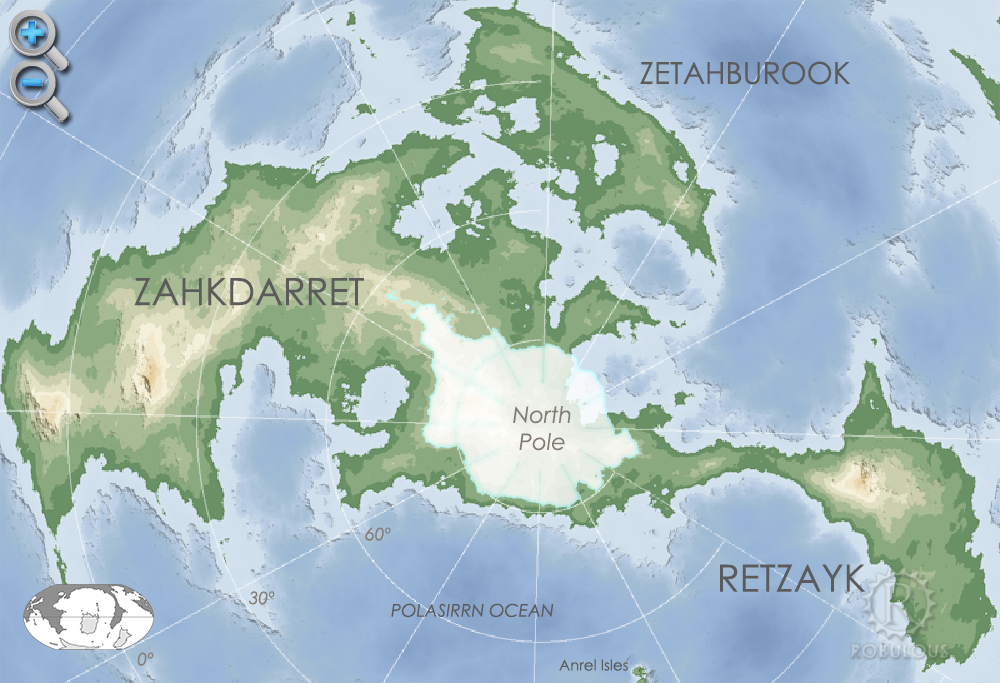
The North Pole or Boreal region is an area of mountains and permanent ice on the supercontinent of Zahkdarret-Retzaykplugin-autotooltip__small plugin-autotooltip_bigZahkdarret-Retzayk
Zahkdarret-Retzayk is a supercontinental landmass consisting of Zahkdarret, Retzayk and the island continent Zetahburook. This contiguous landmass covers most of the northern hemisphere.
North polar projection of the Zahkdarret-Retzayk landmass, showing the average range of north polar ice, extending roughly from 70-90 degrees north. The high mountains store vast amounts of ice, sufficient to reduce Helevos's sea level in cooler epochs. Just a few degrees cooler in the summer months means winter ice does not melt, reducing sea levels by hundreds of metres. The world is currently in a relative warm period so the ice sheet is primarily on land, but in the coldest periods the polar ice extends far into the mountains of Retzayk and Zahkdarret, as well as a thick sheet of sea ice.
 plugin-autotooltip__small plugin-autotooltip_bigAtlas: Zahkdarret
[atlas-zahkdarret.png] * Zoom out
* @ * @ * @ * @ * @ * @ * @ * @ * @ * @
Zahkdarret
Zahkdarret is the largest continent of Helevos, encompassing most of the western hemisphere to the west and north of Anásthias.
North polar projection of the Zahkdarret-Retzayk landmass

Below the polar region is tundra the sparse viridplugin-autotooltip__small plugin-autotooltip_bigVirid
Referring to the Virid Kingdom of flora and fauna, toxic to human life. vegetation, blending to virid ice forest. Few virid species are capable of surviving extreme cold.
The world is currently at its warmest point in the climate cycleplugin-autotooltip__small plugin-autotooltip_bigGlobal Climate Cycle
The Moonscale in fact accurately predicts the motion of the world and surrounding planets, which causes a succession of Glacials (Ice Ages) and Interglacials, which increase and decrease in intensity. These fluctuations are caused by the predictable flucuations of the planet’s axial tilt and other orbital factors. At various tipping points, decades of harsh winters allows buildup of both land and sea ice at the poles. Reduction in sea level alters sea currents, further a…, meaning the ice melts in the warm summers and is limited to the interior and uplands of the polar continent. In earlier epochs, cooler summers allow ice to build up over time, engulfing all of the land and covering the Boreal Sea with ice packs. This dramatically lowers the global sea level. The modern warm period means sea is currently at its highest level point.