Atlas: Vulimé
Anásthiasplugin-autotooltip__small plugin-autotooltip_bigCivilised World
The Civilised World refers to the known regions of human civilisation, notably the continent of Anásthias, the Natorn Archipelago and surrounding islands.
Gastrinimer's 3rd century BME Map of the World, showing Anásthias and the Natorn Isles. Note: old maps place north to the right.AnásthiasAnásthiasAnásthiasAnásthias | Zahkdarretplugin-autotooltip__small plugin-autotooltip_bigZahkdarret
Zahkdarret is the largest continent of Helevos, encompassing most of the western hemisphere to the west and north of Anásthias.
North polar projection of the Zahkdarret-Retzayk landmass, showing the average range of north polar ice
In Mayapo it means “ | Retzaykplugin-autotooltip__small plugin-autotooltip_bigRetzayk
Retzayk is a long, narrow continent approximately 4500 km east of Anásthias, separated from it by the Redeeming Ocean. It extends from the North Pole, crossing the equator and deep into the southern hemisphere.
retzayk
Eastern continent of Retzayk
According to contemporary geography, Retzayk is believed to be one of the Anásthiasviridviridvirid | Vuliméplugin-autotooltip__small plugin-autotooltip_bigVulimé
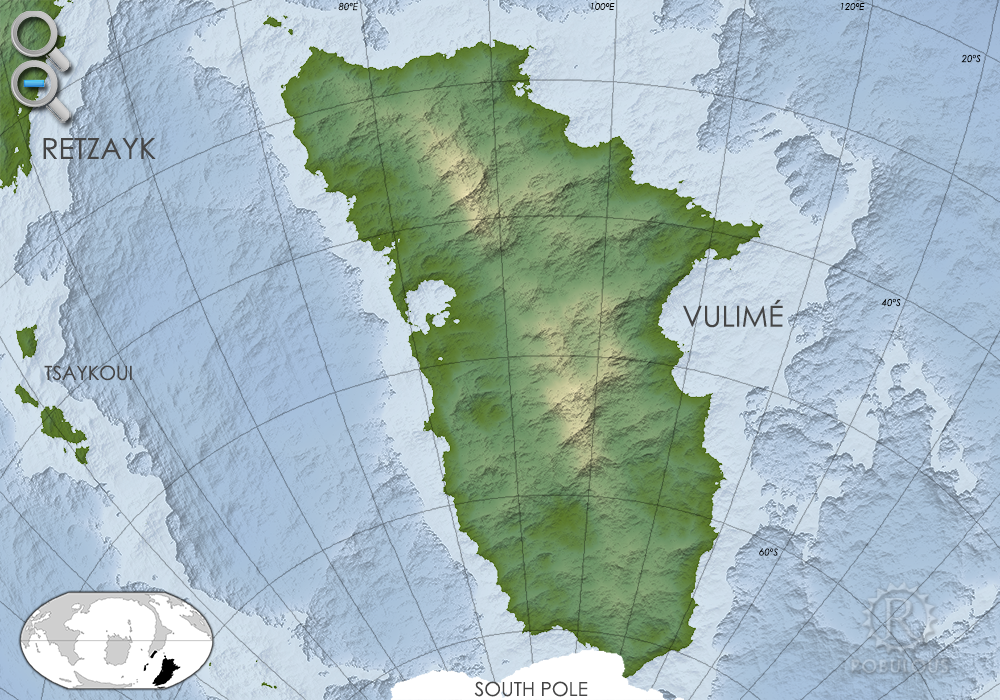
Vulimé, or Voulimay (in Mayápo), is an island continent far to the south and east of Anásthias, more than 10,000km distant. The continent stretches 8400km from 25°S to 75°S , from subtropical forest in the north to icey tundra in the south.
vulime
Geologically it was once connected to | South Poleplugin-autotooltip__small plugin-autotooltip_bigSouth Pole
The South Pole region consists of a permanent cap of ice covering sea, numerous islands and one large island continent, mostly concealed within a pack of sea ice which encompasses latitudes from roughly 75°C to the pole. The ice also encompasses the southern tip of the continent of
Vulimé
Vulimé, or Voulimay (in Mayápoplugin-autotooltip__small plugin-autotooltip_bigMayápo Language
Mayápo or Mayápon [may-YAPP-poe] was the formal language of the ancient realm of Miyarris, spoken for several thousand years in the Celadon Epoch and after.
Language
language
This is in a series of articles about Languages and Communication.
Though it been extinct as a spoken language for almost two thousand years, it continued to be used throughout the Eloyounlanguagelanguagelanguagegreengreengreengreengreen), is an island continentplugin-autotooltip__small far to the south and east of Anásthiasplugin-autotooltip__small plugin-autotooltip_bigAnásthias
Anásthias [a-NAS-thee-ass / ænæsθiːæs], or [an-ass-THEE-as] is an equatorial island continent, heart of the Civilised World. The north straddles the equator and is hot and humid, while most of the equatorial centre is an upland plateau with fertile river valleys, and stretches of arid plains and desert in the shadow of the mountains. The south is temperate but more wild, separated from the civilisations of the north by the almost impassable Harthera, more than 10,000km distant. The continent stretches 8400km from 25°S to 75°S , from subtropical forest in the north to icey tundra in the south.
 plugin-autotooltip__small plugin-autotooltip_bigAtlas: Vulimé
[vulime.png] * Zoom out * Great Urash Ocean
Anásthias | Zahkdarret | Retzayk | Vulimé | South Pole
Vulimé
Vulimé, or Voulimay (in Mayápo), is an island continent far to the south and east of Anásthias, more than 10,000km distant. The continent stretches 8400km from 25°S to 75°S , from subtropical forest in the north to icey tundra in the south.
Geologically it was once connected to Retzaykplugin-autotooltip__small plugin-autotooltip_bigRetzayk
Retzayk is a long, narrow continent approximately 4500 km east of Anásthias, separated from it by the Redeeming Ocean. It extends from the North Pole, crossing the equator and deep into the southern hemisphere.
retzayk
Eastern continent of Retzayk
According to contemporary geography, Retzayk is believed to be one of the Anásthiasviridviridvirid, splitting from the continent overly 100 million years ago. Though geographically separate from the South Polar continentplugin-autotooltip__small plugin-autotooltip_bigSouth Pole
The South Pole region consists of a permanent cap of ice covering sea, numerous islands and one large island continent, mostly concealed within a pack of sea ice which encompasses latitudes from roughly 75°C to the pole. The ice also encompasses the southern tip of the continent of, the southern tip of Vulimé has glaciers that merge with the south polar ice pack, making passage impossible.
It was visited by the ancient Miyarrainplugin-autotooltip__small plugin-autotooltip_bigMiyarrain People
The Miyarrain were the inhabitants of ancient Miyarris, famed as the most advanced civilisation of the Celadon Epoch. The Miyarrain were the progenitors of all modern Eloyoun peoples throughout eastern Anásthias.
The Miyarrain are presumed to be descendants of the Elaymen who predated them, but the exact ethnic origin of Miyarrain people is uncertain. who, according to legend, left a grand carved tomb on the coast of an inland sea, commemorating those who died during the long voyage.
Today little is known about the continent, the name being merely footnote in ancient Miyarrain texts. In the modern mind, Vulimé is just one part of the Edge Landsplugin-autotooltip__small plugin-autotooltip_bigEdge Lands
The Edge Lands are the mytho-geographic lands, said to lie beyond the four oceans surrounding the Civilised World.
They were named by the ancient Miyarrain. Zahkdarret lies to the west of Anásthias, and Retzayk to the east. The cold north is called the Icerealm, the south being the Icehorns.
These names are used in official maps and academic works, but little used in everyday speech. that encircle the Civilised Worldplugin-autotooltip__small plugin-autotooltip_bigCivilised World
The Civilised World refers to the known regions of human civilisation, notably the continent of Anásthias, the Natorn Archipelago and surrounding islands.
Gastrinimer's 3rd century BME Map of the World, showing Anásthias and the Natorn Isles. Note: old maps place north to the right.AnásthiasAnásthiasAnásthiasAnásthias.