La-Err-Rûm
La-Err-Rûm is a nation and ethnolinguistic region in the Dun Jaen mountains, consisting of numerous isolated tribal settlements, villages and a few market towns. The region is not a nation-state in that there is no central government, though the people share a common culture, religion and languageplugin-autotooltip__small plugin-autotooltip_bigLanguages
List of human languages and dialects, contemporary and extinct.
Language
language
This is in a series of articles about Languages and Communication.
topics sidebar cult1.
Munatanplugin-autotooltip__small plugin-autotooltip_bigMunatan (Category)
Articles about Munatan, the far southern region of Anásthias.
Nations
Cities
topics regi1
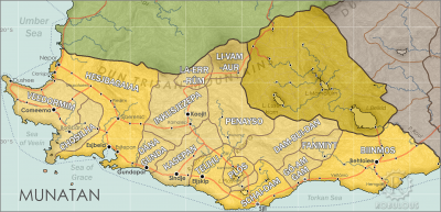
 Hover mouse to see more detail | Go to full atlas mapplugin-autotooltip__small plugin-autotooltip_bigAtlas: Munatan
[munatan.png] * Zoom out * East Munatan * West Munatan
Munatan
Munatan [Moo-Nah-Tahn] is the southernmost region of Anásthias, south of the Dun Trisan mountains. The name possibly derives from a ancient OrorrOrorrOrorrHartheraHartheraOrorrOrorrOrorrHartheraHartheraHartheran
This is in a series of articles about Munatanplugin-autotooltip__small plugin-autotooltip_bigMunatan
Munatan [Moo-Nah-Tahn] is the southernmost region of Anásthias, south of the Dun Trisan mountains. The name possibly derives from a ancient Thalsic, meaning “Land of One Sun”, since the daystar is not visible in the southern hemisphere. Or it may be a reference to the Manthi people who were once the majority population of western Munatan. The term is an OrorrOrorrOrorrHartheraHartheraOrorrOrorrOrorrHartheraHartheraHartheran, the temperate region of southern Anásthiasplugin-autotooltip__small plugin-autotooltip_bigAnásthias
Anásthias [a-NAS-thee-ass / ænæsθiːæs], or [an-ass-THEE-as] is an equatorial island continent, heart of the Civilised World. The north straddles the equator and is hot and humid, while most of the equatorial centre is an upland plateau with fertile river valleys, and stretches of arid plains and desert in the shadow of the mountains. The south is temperate but more wild, separated from the civilisations of the north by the almost impassable Harthera.
In ancient times the region was united by priest-kings, and for a time came under the nominal suzerainty of neighbouring Li-Vam-Aur, but today there is no central authority. However, tribal leaders occasionally gather in a conclave to settle disputes, to solve common threats and broker trade, but these are informal and infrequent.
Geography
The region lies in a large valley approximately 300 km wide, with an average elevation of about 5400 m, surrounded by towering mountains. The terrain is rugged with hills and deep valleys and no navigable rivers, making travel difficult. Consequently most settlements are small and isolated. The low population density means there is little conflict and only a small amount of trade.
Due to the altitude the climate is alpine or tundra, with shallow-rooted, slow-growing viridplugin-autotooltip__small plugin-autotooltip_bigVirid
Referring to the Virid Kingdom of flora and fauna, toxic to human life. ground cover. Much of the soil is permafrost, though the upper soil thaws for up to half of the year. With little virid vegetation, the region was more easily settled by humans than the fertile but virid-forested lowlands. Consequently the Err-rum people farm valleys with a unique form of greenplugin-autotooltip__small plugin-autotooltip_bigGreen
The Green Kingdom of flora and fauna includes humans, mammals, birds, whales, greenfish, and most green plants and crops cultivated by humankind. cultivation, rock farming, in which crops are grown in circular plots surrounded by stones. Loose soil is heaped in the cavity, creating deeper roots for plants and a protected microclimate, shaded from the wind, warmed by rocks heated by the strong sun, and concentrating dew and rainfall.
Culture
The people follow a shamanistic-animistic tradition called Ton-Lobén, which venerates nature spirits of the mountains, residing particularly in rocks and streams.
