Laharkin Mountains
The Laharkin Mountains, also called the Laharkin Range, extend along the eastern coast of Mainland, in the Anrel Isles.
Anrelplugin-autotooltip__small plugin-autotooltip_bigAnrel (Category)
Topics related to the Anrel Isles.
Anrel
Hover/tap image to magnify | Go to world atlas
This is in a series of articles about the Anrel Isles, a significant archipelago in the Natorn Sea.
Nations
Nation Subcategories
Other articles
topics nati1 regi1
 Hover/tap image to magnify | Go to world atlasplugin-autotooltip__small plugin-autotooltip_bigAtlas: Anrel Isles
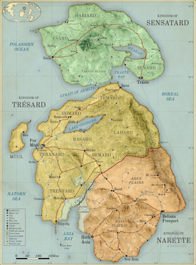
[fmap-anrel_isles.png] * Zoom out * Sensatard * Trésard * Anret
Anrel Isles
Anrel [ANN-rel], or the Anrel Isles, is the most northerly island group in the Natorn Archipelago. It consists of three major islands and numerous smaller ones. The largest, colloquially if infrequently called Mainland, is divided between the kingdoms of
This is in a series of articles about the Anrel Islesplugin-autotooltip__small plugin-autotooltip_bigAnrel Isles
Alternate name for Anrel., a significant archipelago in the Natorn Seaplugin-autotooltip__small plugin-autotooltip_bigNatorn Sea
The Natorn Sea is a region of oceanic ridge, separating the Polassirn Ocean and the Redeeming Ocean. Islands in the ridge form the Natorn Archipelago.
Etymology
The name may be derived from ancient Ahngrit, meaning “near/of our birth”, referring to the legend of the Godmen in which humanity is said to have originated in region now lost beneath the sea. It also relates to the god.
The mountains form a significant geographical barrier, making the eastern shore of Anrelplugin-autotooltip__small plugin-autotooltip_bigAnrel Isles
Anrel [ANN-rel], or the Anrel Isles, is the most northerly island group in the Natorn Archipelago. It consists of three major islands and numerous smaller ones. The largest, colloquially if infrequently called Mainland, is divided between the kingdoms of Trésard and Narette. The island virtually uninhabited. This barrier is not only the high mountains, but their covering of dense viridplugin-autotooltip__small plugin-autotooltip_bigVirid
Referring to the Virid Kingdom of flora and fauna, toxic to human life. forest. Historically the forest was cut back to the foothills allowing upland farming and mining. Many of these foothill settlements were depopulated and abandoned during the Long War, allowing virid forest to spread westward, engulfing the upper reaches of Lake Ondrere.
The mountains formed at the boundary of two continental plates, with the eastern Brumal plate subducting beneath the western Polassirn plate. Eastern Anrel is therefore rising slowly, with the whole landmass sloping from east to west. The mountains suffer occasional earthquakes, and there are two major volcanic peaks in the south. The largest is Mount Arent, dormant throughout recorded history and possibly extinct. The other is Mount Oracil in the far east of Anret, at the southern end of the range, which rumbles occasionally and famously destroyed the city of Oracil in an eruption in 678 BME.