Otekahré
Otekahré [oh-tek-AH-ray] (also called Anarthis in Harthera), is the southeastern region of Anásthias, lying south of Harthera and east of the Dun Jaen mountains. The region has no central governments, but the cities and polities are joined in a loose cultural and economic league, called Kahtoyn. The desert lands to the east have some settled towns and villages that decline participation in the league, as well as nomadic tribes.
In ancient times the coastal area was the civilisation of Miyarris, on of the most advanced civilisations of the ancient world. It was lost at the turn of the Beryl Epoch, when rising sea levels destroyed its proud cities. Miyarrisplugin-autotooltip__small plugin-autotooltip_bigMiyarris
Miyarris [mee-YA-riss], (also Miarris, from Mayápo Mayarous) was a hugely influential ancient civilisation located which flourished during the Celadon Epoch, from 4000-3000 BME. It is considered the first great civilisation in history since the the mythic Godmen.
Ancient Miyarris
BMElanguagelanguagelanguageAnásthiasEloyounlanguagelanguagelanguage is still celebrated in modern culture for its cultural and scientific excellence, with works of science, poetry, philosophy, mathematics, engineering and architecture still essential reading for modern academics.
Otekahréplugin-autotooltip__small plugin-autotooltip_bigOtekahré (Category)
Articles related to Otekahré, the southeast region of the continent of Anásthias.
Otekahré
Hover mouse to see more detail
This is in a series of articles about the region of Otekahré in eastern Anásthias.
topics regi1
 Hover mouse to see more detail
This is in a series of articles about the region of Otekahréplugin-autotooltip__small plugin-autotooltip_bigOtekahré
Otekahré [oh-tek-AH-ray] (also called Anarthis in Harthera), is the southeastern region of Anásthias, lying south of Harthera and east of the Dun Jaen mountains. The region has no central governments, but the cities and polities are joined in a loose cultural and economic league, called HartheraOrorrviridHartheraOrorr in eastern Anásthiasplugin-autotooltip__small plugin-autotooltip_bigAnásthias
Anásthias [a-NAS-thee-ass / ænæsθiːæs], or [an-ass-THEE-as] is an equatorial island continent, heart of the Civilised World. The north straddles the equator and is hot and humid, while most of the equatorial centre is an upland plateau with fertile river valleys, and stretches of arid plains and desert in the shadow of the mountains. The south is temperate but more wild, separated from the civilisations of the north by the almost impassable Harthera.
Name
Otekahré is derived from an Eloyoun word for grazing land for animals. Historically this was the hinterland of ancient Miyarris, wild grazing land beyond the more heavily inhabited coastal cities.
The Hartherans traditionally called it “Anarthis”, meaning “Great Southern Land”. This name is still common, but today the native name is more diplomatic. Local people refer to either Kahtoyn in the east, or Shukioo, the plains in the west.
Geography
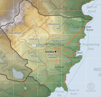
The region is geographically bounded by the Broken Lands to the north, the wide River Roul in the south, and the Dun Jaen mountains to the west. This boundary was formalised by the Torthien Treaty, permanently defining the borders between Harthera and Ororr.
The interior of Otekharé is mainly dry virid plains, hills and greenplugin-autotooltip__small plugin-autotooltip_bigGreen
The Green Kingdom of flora and fauna includes humans, mammals, birds, whales, greenfish, and most green plants and crops cultivated by humankind. grasslands in the centre, with a fertile crescent of agricultural lands nearer the coast, the various polities which make up Kahtoyn.
Political
History
Politically it is dominated by the Eloyoun ceremonial kingdom of Kahtoyn, its colonies and allied city-states, and various nomadic and semi-nomadic ethnic and cultural groups who are loosely allied and follow similar customs.
The most highly developed area is Kahtoyn, which despite having a ceremonial king, is not a monarchy nor even a hierarchical society in the traditional sense. Hartherans, themselves a highly bureaucratic, centralised and organised society, find this anarchic region difficult to comprehend, and so often refer to Kahtoyn and Otekahré interchangeably, although this is very far from the case.
Otekahré was defined as a region as a product of the Torthien Crisis, in which the rival powers of Ororr and Harthera agreed international boundaries and demarcation of their spheres of influence.
Under the Torthien Treaty, Otekahré is defined as “all lands south of the Gulf of Narill, east of the Dun Jaen mountains, and north of the River Roul”.
This includes the traditional Kingdom of Kahtoyn and all the nomadic tribal lands surrounding it. Harthera has now extended its borders to the far side of the Gulf of Narill and the peninsula on its south side, claiming a military need to control the entrance to the River Nar. This is technically a violation of the Treaty, but Ororr has made little more than modest protestations
Tribes
Kinnda Laakmin Porouz Sabouhr Bourip