Atlas: Narillin
 plugin-autotooltip__small plugin-autotooltip_bigAtlas: Union of Harthera
[fmap-harthera.png] * Zoom out * Harlon * Vahltor * Narillin * Junda Isles * @ * @
Political | Geography
atlas nationmaps
Harthera
The Hartheran Union, commonly named Harthera, is an imperialist maritime nation state dominating the northeast of Anásthias. It is one of the two great powers of the viridOrorrMEOrorrOrorrOrorrOrorr
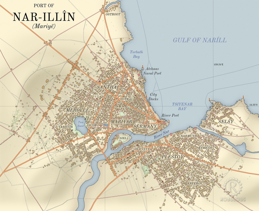
Narillin
Narillin [NAR-ill-EE-in] (Eloyounplugin-autotooltip__small plugin-autotooltip_bigEloyoun People
The Eloyoun people are an ethnic group found throughout eastern and northeastern Anásthias. They are the majority ethnicity in Kahtoyn and most of southern Harthera. Modern Hartheran language and culture is a blend of Eloyoun and Iskean.
The Eloyoun people claim descent from the ancient realm of Harthera Marille, historically Mariyë, also known as the Plaster City) is one of the great port citiesplugin-autotooltip__small plugin-autotooltip_bigPorts
List of key trading ports throughout the Civilised World.
topics geog1 cities1 of the world and the third largest city of Hartheraplugin-autotooltip__small plugin-autotooltip_bigHarthera
The Hartheran Union, commonly named Harthera, is an imperialist maritime nation state dominating the northeast of Anásthias. It is one of the two great powers of the modern epoch, arguably the most technologically and militarily powerful nation in the world, only matched by the vast size and wealth of its neighbour, viridOrorrMEOrorrOrorrOrorrOrorr.


It was an ancient Eloyounplugin-autotooltip__small plugin-autotooltip_bigEloyoun People
The Eloyoun people are an ethnic group found throughout eastern and northeastern Anásthias. They are the majority ethnicity in Kahtoyn and most of southern Harthera. Modern Hartheran language and culture is a blend of Eloyoun and Iskean.
The Eloyoun people claim descent from the ancient realm of Harthera city state, said to have been founded by refugees from Miyarrisplugin-autotooltip__small plugin-autotooltip_bigMiyarris
Miyarris [mee-YA-riss], (also Miarris, from Mayápo Mayarous) was a hugely influential ancient civilisation located which flourished during the Celadon Epoch, from 4000-3000 BME. It is considered the first great civilisation in history since the the mythic Godmen.
Ancient Miyarris
BMElanguagelanguagelanguageAnásthiasEloyounlanguagelanguagelanguage. For much of the modern epochplugin-autotooltip__small plugin-autotooltip_bigModern Epoch (ME)
The Modern Calendar is a dating system acknowledged throughout the Civilised World. It numbers years from the Modern Epoch, abbreviated ME and BME (Before Modern Epoch). It is also called the Modern Era.
Calendar
This is in a series of articles about calendars and dating systems.OrorrHartheraHMOrorrHartheraOrorrOrorrHMHartheraHMHartheraOrorr it was the capital of the Kingdom of Oonarplugin-autotooltip__small plugin-autotooltip_bigOonar
The Kingdom of Oonar, a historic Eloyoun nation in what is now southern Harthera., until its conquest by Hartheraplugin-autotooltip__small plugin-autotooltip_bigHarthera
The Hartheran Union, commonly named Harthera, is an imperialist maritime nation state dominating the northeast of Anásthias. It is one of the two great powers of the modern epoch, arguably the most technologically and militarily powerful nation in the world, only matched by the vast size and wealth of its neighbour, viridOrorrMEOrorrOrorrOrorrOrorr.
Over the last century the city has been extensively remodelled as a commercial hub and military base for the Hartheranplugin-autotooltip__small plugin-autotooltip_bigHarthera
The Hartheran Union, commonly named Harthera, is an imperialist maritime nation state dominating the northeast of Anásthias. It is one of the two great powers of the modern epoch, arguably the most technologically and militarily powerful nation in the world, only matched by the vast size and wealth of its neighbour, viridOrorrMEOrorrOrorrOrorrOrorr navy. Little of the ancient Eloyoun city remains today.
Etymology
The name in Eloyounplugin-autotooltip__small plugin-autotooltip_bigEloyoun People
The Eloyoun people are an ethnic group found throughout eastern and northeastern Anásthias. They are the majority ethnicity in Kahtoyn and most of southern Harthera. Modern Hartheran language and culture is a blend of Eloyoun and Iskean.
The Eloyoun people claim descent from the ancient realm of Harthera derives from island or mound on the River Narplugin-autotooltip__small plugin-autotooltip_bigRiver Nar
The River Nar, also called the Tsiyenar (Rouvawetig) or the Iyé (Eloyoun), is a major river in the south of modern Harthera.
Harthera
This is in a series of articles about Harthera
* Name: Hartheran Union, Union of Harthera, Uhartrah * Government: Military-Mercantile Oligarchy * Capital.
Geography
The city surrounds the estuary of the River Narplugin-autotooltip__small plugin-autotooltip_bigRiver Nar
The River Nar, also called the Tsiyenar (Rouvawetig) or the Iyé (Eloyoun), is a major river in the south of modern Harthera.
Harthera
This is in a series of articles about Harthera
* Name: Hartheran Union, Union of Harthera, Uhartrah * Government: Military-Mercantile Oligarchy * Capital, with clusters of docks and warehouses bristling the coast. The central part of the city is on the north side of the river, with suburbs to the south. Eight kilometres to the south lies the Menarplugin-autotooltip__small plugin-autotooltip_bigMenar
The Menar is a salt lake in southern Harthera, about 8 km south of the city of Narillin. The lake is roughly triangular, 15 km across at its widest point. In ancient times it formed the estuary of the Nar and was linked to the sea, but the river long ago shifted its banks leaving the lake isolated., a salt lake approx 15 km across. The lake was once joined to the sea but its entrance gradually silted up, leaving it isolated. It is a centre for salt production, an important export for the region.
The city is densely populated with tight streets and three or four storey buildings, particularly in the city centre. The city was roughly planned with straight streets and boulevards, but these became increasingly haphazard over time.
History
The city of Mariyë was founded in the Celadon Epochplugin-autotooltip__small plugin-autotooltip_bigCeladon Epoch
Name for the period of history c.6200-3000 BME, also called the Age of Miyarris, after the foremost civilisation of that era., circa 2300 BMEplugin-autotooltip__small plugin-autotooltip_bigBME (Before Modern Epoch)
Used to date years Before the Modern Epoch.. It was constructed on a low plateau above the floodline of the river and sea. From a distance the walls always seemed high and imposing, but this was mostly the hillside which the Oonari cut into a smooth cliff edge. The city was ruled by kings, appointed by a ballot of qualified electors. At the start of a reign, each new king would plaster the walls in his signature colours to mark his stamp on the city. A king had to complete a series of maintenance projects, at his own expense, before being officially crowned.
Peeling walls in the city was considered a sign that a change of government was required, and opposition groups would often paint their colours along the walls or streets as a sign of protest. Competing pretenders would also attempt to delay or paint over official colours in an attempt to forestall the full assumption of the new king's powers.
In later eras the city expanded, and was dubbed the “Plaster City” by detractors in the north, though this name stuck. The city had new walls, but these were of simple mud brick and filler, smoothed over with plaster to give the smooth, organic style of later Oonari art. The fashionable elite built hundreds of towers and spires, which were of little structural integrity or domestic utility, but were mainly a means of showing wealth and status. Towers were painted in a variety of family colours which varied with historic period. As they aged, towers revealed the unfashionable colours of earlier eras, a sure sign of the deterioration of a house.
Features
The Tan Suor is a lake roughly 1km long and half that across, used for recreation and fishing. The western side has extensive parkland open to the public, while the east shore has large villas built by prominent noble families, some of which are now museums and public buildings.
Under the Kingdom of Oonarplugin-autotooltip__small plugin-autotooltip_bigKingdom of Oonar
Oonar was a historic nation in eastern Anásthias existing from c.1800 BME to c.500 ME, with a largely Eloyoun-ethnic population. Around the turn of the first century ME, Oonar was the foremost of the Eloyoun kingdoms in the region, second only to Saloya.
Ancient Northeast Anasthias the western shore was the site of royal tombs and leisure palaces. It was seen as a place where the veil between worlds was thin, so the royal family could communicate with their ancestors, and enjoy private family time. Children were also commonly born here.
After the conquest by Hartheraplugin-autotooltip__small plugin-autotooltip_bigHarthera
The Hartheran Union, commonly named Harthera, is an imperialist maritime nation state dominating the northeast of Anásthias. It is one of the two great powers of the modern epoch, arguably the most technologically and militarily powerful nation in the world, only matched by the vast size and wealth of its neighbour, viridOrorrMEOrorrOrorrOrorrOrorr, some palaces were pulled down, others turned into churches, schools or museums as part of Harthera's cultural reappropriation.