Welcome to Helevos

Mathé Marshes

The Mathé Marshes [MATH-ay] are an area of tidal mud flats, salt marshes and wetlands in the estuary of the River Kethelplugin-autotooltip__small plugin-autotooltip_bigRiver Kethel

The Kethel is a river in the Anrel Isles. It flows from the central plains, through the Mathé Marshes to the sea.

Anrel

Hover/tap image to magnify | Go to world atlas

This is in a series of articles about the Anrel Isles, a significant archipelago in the Natorn Sea.

In previous epochs the Kathel Valley was some of the richest farmland in the isles, home to many towns and cities. In the
in the Anrel Islesplugin-autotooltip__small plugin-autotooltip_bigAnrel Isles

Alternate name for Anrel.
. The marshes form a natural boundary between the Kingdom of Trésardplugin-autotooltip__small plugin-autotooltip_bigKingdom of Trésard

The Hexactic Kingdom of Trésard [tray-SSARD] is a nation in the Anrel Isles, occupying the northern half of the Mainland and the island of Mûul. The kingdom was forged in 238 ME as an alliance of city-states during the Long War, a unification of the states of the former
and the Kingdom of Naretteplugin-autotooltip__small.. The Muthené Marshplugin-autotooltip__small plugin-autotooltip_bigMuthené Marsh

Muthené Marsh is a freshwater wetland in the Kingdom of Trésard in the Anrel Isles. It covers an area of roughly 1500 sq km, criss-crossed with rivers that flow from the Beyal Hills, with hundreds of islands of various sizes. The Muthené Marsh connects with the tidal Mathé Marshes to the south.
in Trésardplugin-autotooltip__small plugin-autotooltip_bigTrésard

Common name for the Kingdom of Trésard.
is an extension of the Mathé Marshes.

Anrelplugin-autotooltip__small plugin-autotooltip_bigAnrel (Category)

Topics related to the Anrel Isles.

Anrel

Hover/tap image to magnify | Go to world atlas

This is in a series of articles about the Anrel Isles, a significant archipelago in the Natorn Sea.

Nations

Nation Subcategories

Other articles

topics nati1 regi1
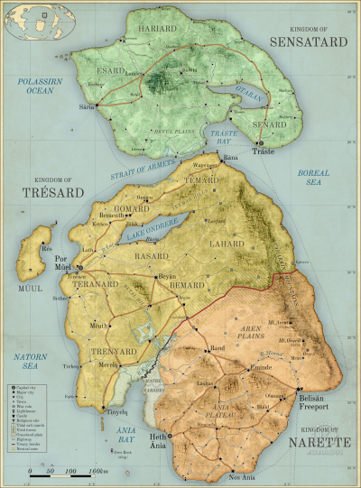
helevos:anrel.png Hover/tap image to magnify | Go to world atlasplugin-autotooltip__small plugin-autotooltip_bigAtlas: Anrel Isles

[fmap-anrel_isles.png] * Zoom out * Sensatard * Trésard * Anret

Anrel Isles

Anrel [ANN-rel], or the Anrel Isles, is the most northerly island group in the Natorn Archipelago. It consists of three major islands and numerous smaller ones. The largest, colloquially if infrequently called Mainland, is divided between the kingdoms of

This is in a series of articles about the Anrel Islesplugin-autotooltip__small plugin-autotooltip_bigAnrel Isles

Alternate name for Anrel.
, a significant archipelago in the Natorn Seaplugin-autotooltip__small plugin-autotooltip_bigNatorn Sea

The Natorn Sea is a region of oceanic ridge, separating the Polassirn Ocean and the Redeeming Ocean. Islands in the ridge form the Natorn Archipelago.

Etymology

The name may be derived from ancient Ahngrit, meaning “near/of our birth”, referring to the legend of the Godmen in which humanity is said to have originated in region now lost beneath the sea. It also relates to the god
.

→ Read more...plugin-autotooltip__small plugin-autotooltip_bigMathé Marshes

The Mathé Marshes [MATH-ay] are an area of tidal mud flats, salt marshes and wetlands in the estuary of the River Kethel in the Anrel Isles. The marshes form a natural boundary between the Kingdom of Trésard and the Kingdom of Narette. The Muthené Marsh in Trésard is an extension of the Mathé Marshes.

Anrel

Hover/tap image to magnify |

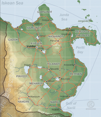
Retthen

Retthen is a coastal cordromeplugin-autotooltip__small plugin-autotooltip_bigCordrome

Harthera

This is in a series of articles about Harthera

* Name: Hartheran Union, Union of Harthera, Uhartrah * Government: Military-Mercantile Oligarchy * Capital: Vahltor * Foundation: 1 ME (Traditional) * Religion: Church of Hartrah * Language: Hartraan (official), also Saloyan, Rouvawetig, Junda

A cordrome is an administrative unit of the
of eastern Hartheraplugin-autotooltip__small plugin-autotooltip_bigHarthera

The Hartheran Union, commonly named Harthera, is an imperialist maritime nation state dominating the northeast of Anásthias. It is one of the two great powers of the modern epoch, arguably the most technologically and militarily powerful nation in the world, only matched by the vast size and wealth of its neighbour, viridOrorrMEOrorrOrorrOrorrOrorr
, comprising what was once eastern Ravorrplugin-autotooltip__small plugin-autotooltip_bigRavorr

Region of modern Harthera, previously a cluster of states called the Baronies of Ravorr.
and the Junda Coastplugin-autotooltip__small plugin-autotooltip_bigJunda Coast

The Junda Coast is a historic term for the east coast of Harthera, particularly in Retthen province, which were settled by migrants from the Junda Isles in 2nd-4th centuries ME.

Harthera

This is in a series of articles about Harthera

* Name: Hartheran Union, Union of Harthera, Uhartrah *
.

Hartheraplugin-autotooltip__small plugin-autotooltip_bigHarthera (Category)

A list of articles related to the nation-state of Harthera

[Harthera]

Regions

Provinces

Cities

Government

Beliefs

People

Ethnic groups

Conflicts

topics nati1

helevos:harthera.png

This is in a series of articles about Hartheraplugin-autotooltip__small plugin-autotooltip_bigHarthera

The Hartheran Union, commonly named Harthera, is an imperialist maritime nation state dominating the northeast of Anásthias. It is one of the two great powers of the modern epoch, arguably the most technologically and militarily powerful nation in the world, only matched by the vast size and wealth of its neighbour, viridOrorrMEOrorrOrorrOrorrOrorr

  • Name: Hartheranplugin-autotooltip__small plugin-autotooltip_bigHarthera

    The Hartheran Union, commonly named Harthera, is an imperialist maritime nation state dominating the northeast of Anásthias. It is one of the two great powers of the modern epoch, arguably the most technologically and militarily powerful nation in the world, only matched by the vast size and wealth of its neighbour, viridOrorrMEOrorrOrorrOrorrOrorr
    Union, Union of Hartheraplugin-autotooltip__small plugin-autotooltip_bigHarthera

    The Hartheran Union, commonly named Harthera, is an imperialist maritime nation state dominating the northeast of Anásthias. It is one of the two great powers of the modern epoch, arguably the most technologically and militarily powerful nation in the world, only matched by the vast size and wealth of its neighbour, viridOrorrMEOrorrOrorrOrorrOrorr
    , Uhartrah
  • Government: Military-Mercantile Oligarchy
  • Capital: Vahltorplugin-autotooltip__small plugin-autotooltip_bigVahltor

    Vahltor is the capital city of Harthera (also: Vultor, Vuhltore; archaic names: Biyahl, Bahl Dorr, Buldoya). It is one of the grandest, wealthiest and most powerful cities in the world, but its surrounding walls limit the city's expansion, creating cramped streets, oppressive towers, poor housing, poverty, disease and squalor in its poorest quarters. It is colloquially known as BMEBMEHartheranHartheraHartheranHartheranHartheranHartheranHartheraHartheranHartheranHartheranHartheranHarther…
  • Foundation: 1 MEplugin-autotooltip__small plugin-autotooltip_bigME

    ME is short for Modern Epoch, the modern method of numbering years.
    (Traditional)
  • Religion: Church of Hartrahplugin-autotooltip__small plugin-autotooltip_bigChurch of Hartrah

    The Church of Hartrah is the state religion of Harthera. It faith combines ancestor worship with the principle of the god, Hartrah, who is the spiritual fusion and synthesis of all the righteous ancestors of the nation who have gone before. Upon death, your spirit begins its ascension and merging with the Godhead. During the lifetime of the family, spirits are still present and contactable, so they can provide guidance and support, and intercede with God to provide strength an…
  • Language: Hartraanplugin-autotooltip__small plugin-autotooltip_bigHartraan

    Hartraan is the official state language of Harthera. All Hartheran citizens are expected to speak Hartraan for official and public use, but in practice most rural people in central and southern Harthera speak local languages as their first language, have only limited exposure to the languagelanguagelanguageHartheralanguage
    (official), also Saloyanplugin-autotooltip__small plugin-autotooltip_bigSaloyan Language

    Saloyan is an Eloyoun language, the principle language of the former Grand Palatinate of Saloya in northeastern Anásthias. A great many dialects existed, several of whom are still spoken in the Salyoan highlands. The majority of people in the region now have Hartraan as their first language.

    Language

    language

    This is in a series of articles about
    , Rouvawetigplugin-autotooltip__small plugin-autotooltip_bigRouvawetig

    Rouvawetig, also called Old Ravorran, is an Eloyoun language spoken by the Rouvawhi people of Ravorr, in central Harthera. Historically the local Eloyoun dialect was heavily influenced by Iskean, particularly the more clipped and gutteral Junda pronunciation, though its vowel inflection is much simplified and its case structure is significantly different.languageEloyounlanguage
    , Jundaplugin-autotooltip__small plugin-autotooltip_bigJunda Language

    Junda, often called Old Junda, is an Iskean language which was once spoken throughout the Junda Isles, Perudd and the Junda Coast.

    Language

    language

    This is in a series of articles about Languages and Communication.

    Isolated dialects are still spoken in remoter parts of the Junda Isles, but it has largely been replaced by languagelanguagelanguagelanguagelanguageHartheralanguagelanguagelanguagelanguagelanguage

Clickable Map

Clickable world mapplugin-autotooltip__small plugin-autotooltip_bigAtlas: Helevos interactive map

[fmap-hemispheres.png] * Zoom in * Zoom out * Planets * Moons * North Pole * South Pole * The Obverse * The Civilised World

Physical/Political map of Helevos. Click red flags to zoom in, or nav buttons to zoom out

< Historical world map

atlas

 
start2.txt · Last modified: 2020/09/10 12:28 (external edit) · []