Anrel Isles
Anrel [ANN-rel], or the Anrel Isles, is the most northerly island group in the Natorn Archipelago. It consists of three major islands and numerous smaller ones. The largest, colloquially if infrequently called Mainland, is divided between the kingdoms of Trésard and Narette. The island Kingdom of Sensatard lies to the north, and the smaller island of Muul to the west. In earlier epochsplugin-autotooltip__small plugin-autotooltip_bigModern Epoch (ME)
The Modern Calendar is a dating system acknowledged throughout the Civilised World. It numbers years from the Modern Epoch, abbreviated ME and BME (Before Modern Epoch). It is also called the Modern Era.
Calendar
This is in a series of articles about calendars and dating systems.OrorrHartheraHMOrorrHartheraOrorrOrorrHMHartheraHMHartheraOrorr the entire group was a single landmass, called Anrasard.
Anrelplugin-autotooltip__small plugin-autotooltip_bigAnrel (Category)
Topics related to the Anrel Isles.
Nations
Nation Subcategories
Other articles
topics nati1 regi1
 Hover/tap image to magnify | Go to world atlasplugin-autotooltip__small plugin-autotooltip_bigAtlas: Anrel Isles
[fmap-anrel_isles.png] * Zoom out * Sensatard * Trésard * Anret
This is in a series of articles about the Anrel Islesplugin-autotooltip__small plugin-autotooltip_bigAnrel Isles
Alternate name for Anrel., a significant archipelago in the Natorn Seaplugin-autotooltip__small plugin-autotooltip_bigNatorn Sea
The Natorn Sea is a region of oceanic ridge, separating the Polassirn Ocean and the Redeeming Ocean. Islands in the ridge form the Natorn Archipelago.
Etymology
The name may be derived from ancient Ahngrit, meaning “near/of our birth”, referring to the legend of the Godmen in which humanity is said to have originated in region now lost beneath the sea. It also relates to the god.
Name
The name Anrel derives from Old Aralsic, meaning “land surrounded by sea”, literally “centre of the water”. During the Little Ice Age, when sea levels lowered sufficiently to connect the north with the mainland, the larger landmass was called Anrasard, “the country of Anrel”. When sea levels rose and the land became islands, it has been called collectively the Anrel Isles.
Geography
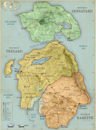
Anrel consists of three large islands: Sensatard, the most northerly in the archipelago, often called Northland; the largest island, called Mainland by other islanders though more commonly referred to by its constituent nations, Trésard and Narette; the westerly island of Muul, plus many smaller islands and rocky islets around the coast.
The islands are roughly 1200 km from north to south at a latitude from 23-30°N, with a maritime climate ranging from cool temperate in the north, to dry grassland in the south. The chief areas of habitation are along the west coast, where war and changes in sea level have caused settlements to shift over time, leaving extensive ruins and little coastal urbanisation more than a few centuries old. The most densely inhabited regions are the fertile green grasslands and managed woodland of the west coast of the Mainland.
The east coast is dominated by the Laharkin Range, a partly volcanic mountain range. The western foothills are remote and flanked by virid forest, while the east coast is mainly vertiginous mountainside plunging down to the sea. A few fishing villages (such as Episcin) cling precariously to the eastern shore, though they are virtually inaccessible except through treacherous mountain passes.
Ethnicity
The peoples of Anrel are mainly Aralsic, though the Beryl Epoch saw the migration of Asokway peoples who landed in the far southeast, colonising the marginal central plains and eastern mountains the length of Anrasard.
Politics
Anrel considers itself the cradle of civilisation, though existence has always been precarious. Today the islands consist of three kingdoms, forged after the Long War which tore island society apart and which killed at least one third of the population. The Kingdom of Sensatard occupies the northern island, and is most often simply called Northland. The largest island, sometimes referred to as Mainland, is split between the kingdoms of Trésard and Narette. The island of Muul, off the west coast of Mainland, is a self governing region of Trésard.
All three are Hexactic Kingdoms, each following a their own interpretation of the Hexact Doctrine, adopted in the period of nation-building and reconstruction following the Long War. Each nation has an aristocratic class who form the principle landowners and the civic officials. These hold their tenure by primenture, by nominal consent of the local people, but are also responsible to the King for upholding the law and maintaining civil defence.
Each government has a monarch who acts as executive of a legislature made up of representatives of the Six Pillars of State, as described in the Hexact Doctrine. These are the Monarch (order and defence), the Conclave of Trades (trade, manufacturing and food production), and the four Hexactic Orders: the Rinesti (Justice), the Cloádi (Learning), the Senasi (Health), and the Minasili or Congregation of Virtue. The monarch is only one member of the Hexactic Council (usually representing Order), though the balance of power between Hexact, monarch, aristocracy and people is different in each nation.
Currency
All three kingdoms produce their own coins and currency, but in practice coins are freely interchangeable and accepted throughout. The official currency throughout Anrel is the Hexactic alm, a hexagonal coin with a circular central hole. The hexagonal shape was chosen so that coins could be cut from a sheet of pressed metal without any wasteage, the hole allowing them to be stacked on poles or tied together for easy transportation.
Alm coins were first introduced by the Northern League during the Long War as ration tokens, which soldiers and refugees could exchange for a basic meal. Today an alm is said to be the value of a loaf of bread, and the Hexact uses primitive monetary policy to retain this value.
There are also gold coins called crowns, produced by the kings of each nation, which are used mainly by the wealthy for large transactions of property and other high-value assets.
Narette also produces silver royals, much to the annoyance of the Hexact, which are now in common circulation throughout Anrel. Trésard recently responded to this by issuing higher denomination 5, 10 and 20-alm coins. There are many other foreign coins in circulation made of other precious metals, and most are accepted by traders throughout the archipelago for the value of the metal alone. Most foreign coins are eventually seized and reminted by the State.
History

In earlier epochsplugin-autotooltip__small plugin-autotooltip_bigWorld History
Helevos has eight thousand years of recorded history, with archeology, artefacts and myth stretching back much further. There are two dominant views of human history: the theological view that the whole world and humanity were created some thousands of years ago in one instant of creation; the second, that all humanity descends from a race of fallen demigods called the viridEmerald EpochBMEgreenBMEAnásthiasAnásthiasBMEAnásthiasfolkloreMiyarrisGodmenBMEMEOrorrHartheraMEviridAnásthi… with a lower sea level, the region of the Anrel Isles was a larger landmass. The most ancient civilisation is referred to as the Realm of the Godmen, though the facts are so lost in myth that little is truly known about this era. In later times this landmass was called Anrasard.
Archeological and historical evidences shows that for most of its history, Anrasard was a shifting patchwork of petty kingdoms and city states, occasionally disputing with each other but largely living in peace.
Disgust at the southeastern slaving city of Oracil united the north into a military alliance that fought what was later called the 'Dragon War', c.2400 HMplugin-autotooltip__small plugin-autotooltip_bigHirèrk Moonscale
The Hirèrk Moonscale [Hee-Rerrk] (HM) is a luni-solar calendar used at least since the time of Miyarris, which measures cycles based on the moons, solar years as well as the millennia-long cycles of global climate change. Today years HM are only seen in historic works and not considered accurate in historical accounts.epochHMHMBMEepochsepochsepochepochepochepochepochHMepochsMEME. After the war, this military alliance united the north into a confederation, whose interactions were mediated by the neutral Magisters of Rasia, who had been elemental in resolving the conflict. The scattered southern tribes and Oracili refugees eventually formed a united kingdom, Narette. Centuries later, tensions were still strong, flowering into a grinding campaign later known as the Long War, in which Naretteian armies obliterated the city of Rasia and laid waste much of modern Tresard. The north was forced to unite under a single war-leader, creating the modern Tresardi kingdom. Over a generation of bloody war was eventually fought to a standstill, and the two nations remained divided for centuries by a physical barrier of dykes, ditches and forts called the Long Wall. The Wall was re-opened for trade only 120 years ago, when the two nations signed a formal peace.
Much of Anrel was once a single landmass called Anrasard, but due to rising sea levels, Anrel proper is now two large islands: the Hexactic Kingdoms of Trésard and Narette to the south, and the island kingdom of Traste to the north, commonly called Northland. There are many small outlying islands, the largest being Res, part of Trésard.