Atlas: Anrel Isles
Anrel Isles
Anrel [ANN-rel], or the Anrel Isles, is the most northerly island group in the Natorn Archipelagoplugin-autotooltip__small plugin-autotooltip_bigNatorn Archipelago
The Natorn Archipelago, or the Natorn Isles [nah-TORN], is a chain of islands in the Natorn Sea. The islands are oceanic ridge running from the northeastern tip of Anásthias to the Anrel Isles. The ridge is an active geological fault, many of the islands being volcanic.Anásthias. It consists of three major islands and numerous smaller ones. The largest, colloquially if infrequently called Mainlandplugin-autotooltip__small plugin-autotooltip_bigMainland
Mainland is the largest of the three major Anrel Isles. Politically it is divided between the two nations of Trésard and Anret.
Anrel
Hover/tap image to magnify | Go to world atlas
This is in a series of articles about the Anrel Isles, a significant archipelago in the Natorn Sea.
The name Mainland is rarely used, except by the inhabitants of smaller outlying islands, particuarly those living on, is divided between the kingdoms of Trésardplugin-autotooltip__small plugin-autotooltip_bigTrésard
Common name for the Kingdom of Trésard. and Naretteplugin-autotooltip__small plugin-autotooltip_bigKingdom of Narette
The Kingdom of Narette, or Naret [na-RET, na rɛt] (arch. Anret or Anrette), is a modern nation occupying the southern half of the largest island in the Anrel Isles. Before the Orphans War it was called the Kingdom of Anrette.
Narette
narette
This is in a series of articles about the AnrelAnrelAnrelAnrelAnrelAnrel. The island Kingdom of Sensatardplugin-autotooltip__small plugin-autotooltip_bigKingdom of Sensatard
The Hexactic Kingdom of Sensatard is an island nation, the northernmost of the Anrel Isles and the northern tip of the Natorn Archipelago. Consequently it is colloquially called Northland, particularly by its inhabitants.
Sensatard
This is in a series of articles about the lies to the north, and the smaller island of Muulplugin-autotooltip__small plugin-autotooltip_bigMûul
Mûul [MOO-ul] is an island in the Kingdom of Trésard, about 40km west of the Mainland of the Anrel Isles. It is separated from the Mainland by the Res Channel.
Geography
Mûul is 150 km north-south, the southern and western half being hilly and windswept, sheltering the lower-lying east coast, which supports livestock and subsistence farming. The island is entirely GodmenGodmengreenGodmen to the west. In earlier epochsplugin-autotooltip__small plugin-autotooltip_bigModern Epoch (ME)
The Modern Calendar is a dating system acknowledged throughout the Civilised World. It numbers years from the Modern Epoch, abbreviated ME and BME (Before Modern Epoch). It is also called the Modern Era.
Calendar
This is in a series of articles about calendars and dating systems.OrorrHartheraHMOrorrHartheraOrorrOrorrHMHartheraHMHartheraOrorr the entire group was a single landmass, called Anrasard.
Anrelplugin-autotooltip__small plugin-autotooltip_bigAnrel (Category)
Topics related to the Anrel Isles.
Nations
Nation Subcategories
Other articles
topics nati1 regi1
 Hover/tap image to magnify | Go to world atlasplugin-autotooltip__small plugin-autotooltip_bigAtlas: Anrel Isles
[fmap-anrel_isles.png] * Zoom out * Sensatard * Trésard * Anret
This is in a series of articles about the Anrel Islesplugin-autotooltip__small plugin-autotooltip_bigAnrel Isles
Alternate name for Anrel., a significant archipelago in the Natorn Seaplugin-autotooltip__small plugin-autotooltip_bigNatorn Sea
The Natorn Sea is a region of oceanic ridge, separating the Polassirn Ocean and the Redeeming Ocean. Islands in the ridge form the Natorn Archipelago.
Etymology
The name may be derived from ancient Ahngrit, meaning “near/of our birth”, referring to the legend of the Godmen in which humanity is said to have originated in region now lost beneath the sea. It also relates to the god.
Name
The name Anrel derives from Old Aralsicplugin-autotooltip__small plugin-autotooltip_bigOld Aralsic
Old Aralsic is a language which emerged in Anrasard during the Jade Epoch. It is the ancestor of all the modern Aralsic languages spoken in the Natorn Archipelago.
Language
language
This is in a series of articles about Languages and Communication.
Old Aralsic is said to have descended from the languages of the Godmen, particularly Atantic or Ahngrit. So little is known about these ancient tongues that it is impossible to be certain., meaning “land surrounded by sea”, literally “centre of the water”. During the Little Ice Ageplugin-autotooltip__small plugin-autotooltip_bigLittle Ice Age
The Little Ice Age is a historical epoch within Helevos's climate cycle, a roughly 700-year period of global cooling from 50 BME to 650 ME. A series of cooler summers caused a net fall in global temperatures, with a consequent lowering of sea level of up to three metres. This not only had a big impact on low-lying coastal areas but caused climate change sufficient to upset the balance of power of global economies, contributing to the fall of the, when sea levels lowered sufficiently to connect the north with the mainland, the larger landmass was called Anrasard, “the country of Anrel”. When sea levels rose and the land became islands, it has been called collectively the Anrel Isles.
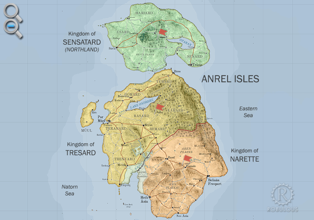
Geography
Anrel consists of three large islands: Sensatardplugin-autotooltip__small plugin-autotooltip_bigKingdom of Sensatard
The Hexactic Kingdom of Sensatard is an island nation, the northernmost of the Anrel Isles and the northern tip of the Natorn Archipelago. Consequently it is colloquially called Northland, particularly by its inhabitants.
Sensatard
This is in a series of articles about the, the most northerly in the archipelago, often called Northland; the largest island, called Mainlandplugin-autotooltip__small plugin-autotooltip_bigMainland
Mainland is the largest of the three major Anrel Isles. Politically it is divided between the two nations of Trésard and Anret.
Anrel
Hover/tap image to magnify | Go to world atlas
This is in a series of articles about the Anrel Isles, a significant archipelago in the Natorn Sea.
The name Mainland is rarely used, except by the inhabitants of smaller outlying islands, particuarly those living on by other islanders though more commonly referred to by its constituent nations, Trésardplugin-autotooltip__small plugin-autotooltip_bigTrésard
Common name for the Kingdom of Trésard. and Naretteplugin-autotooltip__small plugin-autotooltip_bigKingdom of Narette
The Kingdom of Narette, or Naret [na-RET, na rɛt] (arch. Anret or Anrette), is a modern nation occupying the southern half of the largest island in the Anrel Isles. Before the Orphans War it was called the Kingdom of Anrette.
Narette
narette
This is in a series of articles about the AnrelAnrelAnrelAnrelAnrelAnrel; the westerly island of Muulplugin-autotooltip__small plugin-autotooltip_bigMûul
Mûul [MOO-ul] is an island in the Kingdom of Trésard, about 40km west of the Mainland of the Anrel Isles. It is separated from the Mainland by the Res Channel.
Geography
Mûul is 150 km north-south, the southern and western half being hilly and windswept, sheltering the lower-lying east coast, which supports livestock and subsistence farming. The island is entirely GodmenGodmengreenGodmen, plus many smaller islands and rocky islets around the coast.
The islands are roughly 1200 km from north to south at a latitude from 23-30°N, with a maritime climate ranging from cool temperate in the north, to dry grassland in the south. The chief areas of habitation are along the west coast, where war and changes in sea level have caused settlements to shift over time, leaving extensive ruins and little coastal urbanisation more than a few centuries old. The most densely inhabited regions are the fertile greenplugin-autotooltip__small plugin-autotooltip_bigGreen
The Green Kingdom of flora and fauna includes humans, mammals, birds, whales, greenfish, and most green plants and crops cultivated by humankind. grasslands and managed woodland of the west coast of the Mainlandplugin-autotooltip__small plugin-autotooltip_bigMainland
Mainland is the largest of the three major Anrel Isles. Politically it is divided between the two nations of Trésard and Anret.
Anrel
Hover/tap image to magnify | Go to world atlas
This is in a series of articles about the Anrel Isles, a significant archipelago in the Natorn Sea.
The name Mainland is rarely used, except by the inhabitants of smaller outlying islands, particuarly those living on.
The east coast is dominated by the Laharkin Rangeplugin-autotooltip__small plugin-autotooltip_bigLaharkin Range
Common name for the Laharkin Mountains in Anrel., a partly volcanic mountain range. The western foothills are remote and flanked by viridplugin-autotooltip__small plugin-autotooltip_bigVirid
Referring to the Virid Kingdom of flora and fauna, toxic to human life. forest, while the east coast is mainly vertiginous mountainside plunging down to the sea. A few fishing villages (such as Episcinplugin-autotooltip__small plugin-autotooltip_bigEpiscin
Episcin [EP-is-sin] is a mainly ruined settlement on the east coast of Anrel, on what is now the border between Tresard and Narette. In the 1st century ME it became a retreat for wealthy nobles as well as scholars from the city of Rasia, who wished a private retreat far from the austerity and observance of the) cling precariously to the eastern shore, though they are virtually inaccessible except through treacherous mountain passes.
Ethnicity
The peoples of Anrel are mainly Aralsicplugin-autotooltip__small plugin-autotooltip_bigAralsic
Referring to the Aralsic peoples, or the family of Aralsic languages., though the Beryl Epochplugin-autotooltip__small plugin-autotooltip_bigBeryl Epoch
Historic epoch, age of the Empire of Dor-en-Sann. saw the migration of Asokway peoples who landed in the far southeast, colonising the marginal central plains and eastern mountains the length of Anrasard.
Politics
Anrel considers itself the cradle of civilisation, though existence has always been precarious. Today the islands consist of three kingdoms, forged after the Long Warplugin-autotooltip__small plugin-autotooltip_bigLong War
The Long War (219-263 ME) was the bloodiest conflict in the history of the Anrel Isles, between the allied city-states of the Northern League (now the kingdoms of Trésard and Sensatard), and the Kingdom of Narette. It is often bitterly called the Orphans' War, since it went on so long it was fought by two generations of people whose own parents had been killed in the war.viridAnrelmagicAnrelAnrel which tore island society apart and which killed at least one third of the population. The Kingdom of Sensatardplugin-autotooltip__small plugin-autotooltip_bigKingdom of Sensatard
The Hexactic Kingdom of Sensatard is an island nation, the northernmost of the Anrel Isles and the northern tip of the Natorn Archipelago. Consequently it is colloquially called Northland, particularly by its inhabitants.
Sensatard
This is in a series of articles about the occupies the northern island, and is most often simply called Northland. The largest island, sometimes referred to as Mainlandplugin-autotooltip__small plugin-autotooltip_bigMainland
Mainland is the largest of the three major Anrel Isles. Politically it is divided between the two nations of Trésard and Anret.
Anrel
Hover/tap image to magnify | Go to world atlas
This is in a series of articles about the Anrel Isles, a significant archipelago in the Natorn Sea.
The name Mainland is rarely used, except by the inhabitants of smaller outlying islands, particuarly those living on, is split between the kingdoms of Trésardplugin-autotooltip__small plugin-autotooltip_bigTrésard
Common name for the Kingdom of Trésard. and Naretteplugin-autotooltip__small plugin-autotooltip_bigKingdom of Narette
The Kingdom of Narette, or Naret [na-RET, na rɛt] (arch. Anret or Anrette), is a modern nation occupying the southern half of the largest island in the Anrel Isles. Before the Orphans War it was called the Kingdom of Anrette.
Narette
narette
This is in a series of articles about the AnrelAnrelAnrelAnrelAnrelAnrel. The island of Muulplugin-autotooltip__small plugin-autotooltip_bigMûul
Mûul [MOO-ul] is an island in the Kingdom of Trésard, about 40km west of the Mainland of the Anrel Isles. It is separated from the Mainland by the Res Channel.
Geography
Mûul is 150 km north-south, the southern and western half being hilly and windswept, sheltering the lower-lying east coast, which supports livestock and subsistence farming. The island is entirely GodmenGodmengreenGodmen, off the west coast of Mainland, is a self governing region of Trésard.
All three are Hexactic Kingdoms, each following a their own interpretation of the Hexact Doctrineplugin-autotooltip__small plugin-autotooltip_bigHexact Doctrine
The Hexact Doctrine is a philosophy of government developed in Anrel in the early 3rd century ME, with the aim of creating governments that benefited the health, wealth and wellbeing of its citizens. It is the model for many governments throughout the MEAnrelAnrelAnrelAnrelAnrelAnrelAnrel, adopted in the period of nation-building and reconstruction following the Long War. Each nation has an aristocratic classplugin-autotooltip__small plugin-autotooltip_bigAnrel Aristocracy
The Anrel Isles are governed by a class collectively called the Grafen or Graves, individually given the courtesy title Graf. Leaders of towns, cities, and even nations are drawn from this class. Traditionally, leaders are selected by will of the populace, based on their personal qualities and family merits, according to the traditional honour system of Anrel who form the principle landowners and the civic officials. These hold their tenure by primentureplugin-autotooltip__small plugin-autotooltip_bigPrimenture
Primenture is a social structure found particularly in the Natorn Archipelago, used to determine social rank and leadership. Primenture means leadership by those who are perceived to have the most social capital, and therefore usually, though not always, the most able., by nominal consent of the local people, but are also responsible to the King for upholding the law and maintaining civil defence.
Each government has a monarch who acts as executive of a legislature made up of representatives of the Six Pillars of State, as described in the Hexact Doctrine. These are the Monarch (order and defence), the Conclave of Trades (trade, manufacturing and food production), and the four Hexactic Orders: the Rinestiplugin-autotooltip__small plugin-autotooltip_bigRinesti
Rinesti are one of the Hexact Orders, dedicated to law and good governance. (Justice), the Cloádiplugin-autotooltip__small plugin-autotooltip_bigCloadi
Cloadi are one of the Hexact Orders, dedicated to learning and education. (Learning), the Senasiplugin-autotooltip__small plugin-autotooltip_bigSenasi
The Senasi are an organisation dedicated to health and healing in the Anrel Isles. They are one of the Hexact Orders, advocating for health in national politics. Senasi order members are healers and physicians, tending to the sick and providing health advice throughout the islands. They wear white, and their healing houses are found in all major towns and cities. (Health), and the Minasiliplugin-autotooltip__small plugin-autotooltip_bigMinasili
The Minasili are one of the Hexact Orders, dedicated to faith and religious practice.
Belief
This is in a series of articles about religions and beliefs.
anrel beliefs institutions anrelpantheon or Congregation of Virtue. The monarch is only one member of the Hexactic Council (usually representing Order), though the balance of power between Hexact, monarch, aristocracy and people is different in each nation.
Currency
All three kingdoms produce their own coins and currency, but in practice coins are freely interchangeable and accepted throughout. The official currency throughout Anrel is the Hexactic almplugin-autotooltip__small plugin-autotooltip_bigHexactic Alm
The Hexactic Alm [ARM] is the official currency of the nations of Anrel, accepted throughout the Natorn Archipelago. An alm is worth six pins, and 24 alms are a crown.
Money
[ ]
This is in a series of articles about money, currencies and finance.
The alm originally a food token given to refugees during the Anrel, a hexagonal coin with a circular central hole. The hexagonal shape was chosen so that coins could be cut from a sheet of pressed metal without any wasteage, the hole allowing them to be stacked on poles or tied together for easy transportation.
Alm coins were first introduced by the Northern Leagueplugin-autotooltip__small plugin-autotooltip_bigNorthern League
The Northern League was a confederation of regions and city states in Anrasard (the landmass contiguous with the modern Anrel Isles, which united against the southern forces of Anret during the Long War.
Anrel
Hover/tap image to magnify | Go to world atlas
This is in a series of articles about the during the Long Warplugin-autotooltip__small plugin-autotooltip_bigLong War
The Long War (219-263 ME) was the bloodiest conflict in the history of the Anrel Isles, between the allied city-states of the Northern League (now the kingdoms of Trésard and Sensatard), and the Kingdom of Narette. It is often bitterly called the Orphans' War, since it went on so long it was fought by two generations of people whose own parents had been killed in the war.viridAnrelmagicAnrelAnrel as ration tokens, which soldiers and refugees could exchange for a basic meal. Today an alm is said to be the value of a loaf of bread, and the Hexact uses primitive monetary policy to retain this value.
There are also gold coins called crowns, produced by the kings of each nation, which are used mainly by the wealthy for large transactions of property and other high-value assets.
Narette also produces silver royals, much to the annoyance of the Hexact, which are now in common circulation throughout Anrel. Trésard recently responded to this by issuing higher denomination 5, 10 and 20-alm coins. There are many other foreign coins in circulation made of other precious metals, and most are accepted by traders throughout the archipelago for the value of the metal alone. Most foreign coins are eventually seized and reminted by the State.
History

In earlier epochsplugin-autotooltip__small plugin-autotooltip_bigWorld History
Helevos has eight thousand years of recorded history, with archeology, artefacts and myth stretching back much further. There are two dominant views of human history: the theological view that the whole world and humanity were created some thousands of years ago in one instant of creation; the second, that all humanity descends from a race of fallen demigods called the viridEmerald EpochBMEgreenBMEAnásthiasAnásthiasBMEAnásthiasfolkloreMiyarrisGodmenBMEMEOrorrHartheraMEviridAnásthi… with a lower sea level, the region of the Anrel Isles was a larger landmass. The most ancient civilisation is referred to as the Realm of the Godmenplugin-autotooltip__small plugin-autotooltip_bigRealm of the Godmen
The Realm of the Godmen was semi-mythic ancient civilisation, said to have existed in the Emerald Epoch from roughly 15,000-12,000 BME. It was the home of the mythical Godmen, the said to have been the first human civilisation from which all mankind descends. Godmen, though the facts are so lost in myth that little is truly known about this era. In later times this landmass was called Anrasard.
Archeological and historical evidences shows that for most of its history, Anrasard was a shifting patchwork of petty kingdoms and city states, occasionally disputing with each other but largely living in peace.
Disgust at the southeastern slaving city of Oracil united the north into a military alliance that fought what was later called the 'Dragon War', c.2400 HMplugin-autotooltip__small plugin-autotooltip_bigHirèrk Moonscale
The Hirèrk Moonscale [Hee-Rerrk] (HM) is a luni-solar calendar used at least since the time of Miyarris, which measures cycles based on the moons, solar years as well as the millennia-long cycles of global climate change. Today years HM are only seen in historic works and not considered accurate in historical accounts.epochHMHMBMEepochsepochsepochepochepochepochepochHMepochsMEME. After the war, this military alliance united the north into a confederation, whose interactions were mediated by the neutral Magisters of Rasia, who had been elemental in resolving the conflict. The scattered southern tribes and Oracili refugees eventually formed a united kingdom, Narette. Centuries later, tensions were still strong, flowering into a grinding campaign later known as the Long War, in which Naretteian armies obliterated the city of Rasia and laid waste much of modern Tresard. The north was forced to unite under a single war-leader, creating the modern Tresardi kingdom. Over a generation of bloody war was eventually fought to a standstill, and the two nations remained divided for centuries by a physical barrier of dykes, ditches and forts called the Long Wall. The Wall was re-opened for trade only 120 years ago, when the two nations signed a formal peace.
Much of Anrel was once a single landmass called Anrasardplugin-autotooltip__small plugin-autotooltip_bigAnrasard
Anrasard was a landmass contiguous with the modern Anrel Isles. In earlier epochs the sea level was much lower, so the isles formed single large island.
Anrasard was at its greatest extent during the Emerald Epoch some 14,000 years ago, in the mythic age of the Godmen. In subsequent, but due to rising sea levels, Anrel proper is now two large islands: the Hexactic Kingdoms of Trésard and Narette to the south, and the island kingdom of Traste to the north, commonly called Northland. There are many small outlying islands, the largest being Res, part of Trésard.