 plugin-autotooltip__small plugin-autotooltip_bigEmpire of Dor-en-Sann
The Empire of Dor-en-Sann, [DOORR-enn-SAHN] also called the EnSanni Empire, was the largest empire in history. It dominated central Anásthias for nearly two thousand years, from 1903 BME, until the conquest of Galkesh in 59 ME. The empire consisted of hundreds of ethnic groups and cultures, its people were collectively called the MEOrorrHMOrorrHMHartheraME
Old Empire of Dor-en-Sann
Welcome to Helevos
 plugin-autotooltip__small plugin-autotooltip_bigAtlas: Helevos interactive map
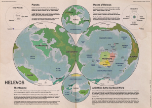
[fmap-hemispheres.png] * Zoom in * Zoom out * Planets * Moons * North Pole * South Pole * The Obverse * The Civilised World
Physical/Political map of Helevos. Click red flags to zoom in, or nav buttons to zoom out
< Historical world map
atlas
Helevos
Helevos (also known as Vos, or Veeos) is a temperate terrestrial world, fourth planet of the star Cordes in the viridgreenAnásthiasAnásthiasAnásthiasgreen
- Click for interactive world map
Helevosplugin-autotooltip__small plugin-autotooltip_bigHelevos
Helevos (also known as Vos, or Veeos) is a temperate terrestrial world, fourth planet of the star Cordes in the Cronox binary star system. The stars Cordes and Arjos are distant binaries, so on Helevos, Arjos is only seen in the northern hemisphere as star, sometimes bright enough to be seen during the day, circling roughly over the viridgreenAnásthiasAnásthiasAnásthiasgreen is a fantasy world of magicplugin-autotooltip__small plugin-autotooltip_bigMagic
In common terms, magic is the art of producing a desired outcome through occult means. Various arts are described as magical, from common street illusionists, village herbalists, and rituals for the intercession of deities. However, true magic is the art and science of elemental mastery, harnessing elemental creatures and instructing them to perform simple or complex tasks. and science, divided by two incompatible biologies: the Green Kingdomplugin-autotooltip__small plugin-autotooltip_bigGreen
The Green Kingdom of flora and fauna includes humans, mammals, birds, whales, greenfish, and most green plants and crops cultivated by humankind. of humans, trees, grasses, cropsplugin-autotooltip__small plugin-autotooltip_bigFlora
Topics related to herbs, crops and plantlife.
Subcategories
Articles
All
Green Flora
Virid Flora
topics sci1 and red-blooded animalsplugin-autotooltip__small plugin-autotooltip_bigMammals
List of red-blooded mammals, members of the Green Kingdom closely related to humans.
Fauna
This is in a series of articles about Animals.
topics faun1, and the Virid Kingdomplugin-autotooltip__small plugin-autotooltip_bigVirid
Referring to the Virid Kingdom of flora and fauna, toxic to human life. of toxic jungles, poisonous plants, terrifying creatures and airborne infectionsplugin-autotooltip__small plugin-autotooltip_bigSpor
Spor are the single-celled reproductive units of virid plants, distinct from seeds or spores found in the green kingdom. Most spor are airborne, release from spor-pods, the fruiting bodies of virid plants. Many spor are motile with rudimentary flagella, either fertilising mature plants, or randomly bonding with the spor of other plants and settling to make a new plant seedling.viridviridvirid.
Over thousands of years humans have forged the hundred nationsplugin-autotooltip__small plugin-autotooltip_bigModern Nations
The Civilised World has many nations, from small island republics to vast continental empires, which over the millennia have carved homelands out of the once hostile virid landscape. The two great opposing world powers of today are the holy nation of Ororr and the maritime empire of of the Civilised Worldplugin-autotooltip__small plugin-autotooltip_bigCivilised World
The Civilised World refers to the known regions of human civilisation, notably the continent of Anásthias, the Natorn Archipelago and surrounding islands.
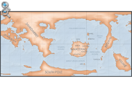
Gastrinimer's 3rd century BME Map of the World, showing Anásthias and the Natorn Isles. Note: old maps place north to the right.AnásthiasAnásthiasAnásthiasAnásthias on the island continent of Anásthiasplugin-autotooltip__small plugin-autotooltip_bigAnásthias
Anásthias [a-NAS-thee-ass / ænæsθiːæs], or [an-ass-THEE-as] is an equatorial island continent, heart of the Civilised World. The north straddles the equator and is hot and humid, while most of the equatorial centre is an upland plateau with fertile river valleys, and stretches of arid plains and desert in the shadow of the mountains. The south is temperate but more wild, separated from the civilisations of the north by the almost impassable Harthera, dominated by the two Great Powersplugin-autotooltip__small plugin-autotooltip_bigGreat Powers
Great Powers are the most powerful nations in the world, the greatest modern powers being Ororr and Harthera.: the magicalplugin-autotooltip__small plugin-autotooltip_bigMagic
In common terms, magic is the art of producing a desired outcome through occult means. Various arts are described as magical, from common street illusionists, village herbalists, and rituals for the intercession of deities. However, true magic is the art and science of elemental mastery, harnessing elemental creatures and instructing them to perform simple or complex tasks. theocracyplugin-autotooltip__small plugin-autotooltip_bigMother Church of Ororr (Therism)
The Mother Church is the state religion of Ororr, which combines both religion and government in one institution. It is based on the teachings of the Great Prophet Therion, who in the early decades of the modern era raised an army that conquered much of northwestern OrorrOrorrOrorrOrorrOrorrMEMEOrorrMEMEOrorrOrorrHerHerHerHerHerHerHerHerHerher of Ororrplugin-autotooltip__small plugin-autotooltip_bigOrorr
Ororr [o-ROARR, ɒ̝rɔ'ɾ], also called the Holy Motherland of Ororr, is a theocratic nation in Anásthias, one of the world's great powers. It the largest nation in the world, perhaps the largest empire in history, occupying the entire northwest of the continent between the mountains and the sea. Ororrlanguagelanguagelanguage, and the steam-powered naval might of Hartheraplugin-autotooltip__small plugin-autotooltip_bigHarthera
The Hartheran Union, commonly named Harthera, is an imperialist maritime nation state dominating the northeast of Anásthias. It is one of the two great powers of the modern epoch, arguably the most technologically and militarily powerful nation in the world, only matched by the vast size and wealth of its neighbour, viridOrorrMEOrorrOrorrOrorrOrorr.
 plugin-autotooltip__small plugin-autotooltip_bigVirid
Referring to the Virid Kingdom of flora and fauna, toxic to human life.
Random images


Clickable Map
 plugin-autotooltip__small plugin-autotooltip_bigAtlas: Helevos interactive map
[fmap-hemispheres.png] * Zoom in * Zoom out * Planets * Moons * North Pole * South Pole * The Obverse * The Civilised World
Physical/Political map of Helevos. Click red flags to zoom in, or nav buttons to zoom out
< Historical world map
atlas
Helevos
Helevos (also known as Vos, or Veeos) is a temperate terrestrial world, fourth planet of the star Cordes in the viridgreenAnásthiasAnásthiasAnásthiasgreen

New & Updated
Today's date
Pages & images
1112 articles 390 maps & images
Recent updates
All contents © 2025 Robert How, robulous.com