Atlas: Anásthias Geographical Features
Zoom inZoom outOrorrHarthera|OtekahrétorthienMunatanZoom Out
  • Zoom inplugin-autotooltip__small plugin-autotooltip_bigAtlas: Civilised World

    [fmap-civworld.png] * Zoom in * Zoom out * Azri Isles * Eastern Isles * Anásthias * Vetthi Republic @ * Crish & Varg @ * Natorn Archipelago * Polassirn Ocean * Great Urash Ocean * Brumal Deep * Redeeming Ocean * Retzayk * Tsaykoui * New Hartrah Colony * Zahkdarret * Hi-Li-Ven * Barrier Isles * South Pole * Orodien * Vesmien Ocean * North Pole

    Civilised World

    The Civilised World refers to the known regions of human civilisat…
  • Zoom outplugin-autotooltip__small plugin-autotooltip_bigAtlas: Civilised World

    [fmap-civworld.png] * Zoom in * Zoom out * Azri Isles * Eastern Isles * Anásthias * Vetthi Republic @ * Crish & Varg @ * Natorn Archipelago * Polassirn Ocean * Great Urash Ocean * Brumal Deep * Redeeming Ocean * Retzayk * Tsaykoui * New Hartrah Colony * Zahkdarret * Hi-Li-Ven * Barrier Isles * South Pole * Orodien * Vesmien Ocean * North Pole

    Civilised World

    The Civilised World refers to the known regions of human civilisat…
  • Ororrplugin-autotooltip__small plugin-autotooltip_bigAtlas: Ororr

    [fmap-ororr.png] * Zoom out * Gildon * Moritarr * Deltirot * Dunasanin * Gaskanin * Mangasor * @ * @

    Political | Geography

    atlas nationmaps

    Ororr

    Ororr [o-ROARR, ɒ̝rɔ'ɾ], also called the Holy Motherland of Ororr, is a theocratic nation in Anásthias, one of the world's great powers. It the largest nation in the world, perhaps the largest empire in history, occupying the entire northwest of the continent between the mountains and the sea. Ororrlanguagelang…
  • Harthera|plugin-autotooltip__small plugin-autotooltip_bigHarthera

    The Hartheran Union, commonly named Harthera, is an imperialist maritime nation state dominating the northeast of Anásthias. It is one of the two great powers of the modern epoch, arguably the most technologically and militarily powerful nation in the world, only matched by the vast size and wealth of its neighbour, viridOrorrMEOrorrOrorrOrorrOrorr
  • Otekahréplugin-autotooltip__small plugin-autotooltip_bigAtlas: Otekahré

    [atlas-otekahre.png] * Zoom in * Zoom out

    * @ * @ * @ * @ * @ * @ * @ * @ * @ * @

    Otekahré

    Otekahré [oh-tek-AH-ray] (also called Anarthis in Harthera), is the southeastern region of Anásthias, lying south of Harthera and east of the Dun Jaen mountains. The region has no central governments, but the cities and polities are joined in a loose cultural and economic league, called HartheraOrorrviridHartheraOrorr
  • torthienplugin-autotooltip__small plugin-autotooltip_bigAtlas: Taur-Dji-Oum (Torthien)

    [fmap-torthien.png] * Zoom out

    * @ * @ * @ * @ * @ * @ * @ * @ * @ * @

    Taur-Dji-Oum

    Taur-Dji-Oum [Tower-shjee-ohm], known as Torthien in much of the Civilised World, also called the Vale of Tortanis in Ororr, is an upland area of southeastern Anásthias. It is a politically complex and unstable region, consisting of twenty-three major ethnic nations, territorially sub-divided into smaller kingdoms, chiefdoms, fiefdoms a…
  • Munatanplugin-autotooltip__small plugin-autotooltip_bigMunatan

    Munatan [Moo-Nah-Tahn] is the southernmost region of Anásthias, south of the Dun Trisan mountains. The name possibly derives from a ancient Thalsic, meaning “Land of One Sun”, since the daystar is not visible in the southern hemisphere. Or it may be a reference to the Manthi people who were once the majority population of western Munatan. The term is an OrorrOrorrOrorrHartheraHartheraOrorrOrorrOrorrHartheraHartheraHartheran
  • Zoom Outplugin-autotooltip__small plugin-autotooltip_bigAtlas: Helevos interactive map

    [fmap-hemispheres.png] * Zoom in * Zoom out * Planets * Moons * North Pole * South Pole * The Obverse * The Civilised World

    Physical/Political map of Helevos. Click red flags to zoom in, or nav buttons to zoom out

    < Historical world map

    atlas

    Helevos

    Helevos (also known as Vos, or Veeos) is a temperate terrestrial world, fourth planet of the star Cordes in the viridgreenAnásthiasAnásthiasAnásthiasgreen

| Modern Political Mapplugin-autotooltip__small plugin-autotooltip_bigAtlas: Anásthias

[fmap-anasthias.png] * Zoom out * Holy Motherland of Ororr * Union of Harthera * Region of Otekahré * Region of Taur-dji-Oum * Region of Munatan * Zoom Out * Vetthi Republic

atlas

Anásthias

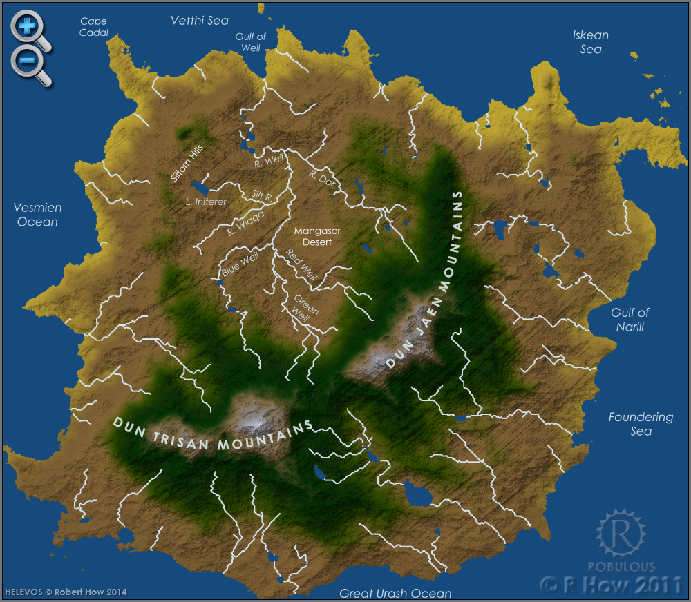
Anásthias [a-NAS-thee-ass / ænæsθiːæs], or [an-ass-THEE-as] is an equatorial island continent, heart of the Civilised World. The north straddles the equator and is hot and humid, while most of the equatorial centre is an upland plateau with fertile river valleys, and stre…
| Geographyplugin-autotooltip__small plugin-autotooltip_bigAtlas: Anásthias Geographical Features

[map-anasthias_geog.png] * Zoom in * Zoom out * Ororr * Harthera| * Otekahré * torthien * Munatan * Zoom Out
| Poster versionplugin-autotooltip__small plugin-autotooltip_bigAtlas: Anásthias (Poster version)

[Zoom out?]

Hover mouse/tap image to magnify

| Modern Political Map | Geography | Poster version | 1st Century History |

atlas

atlas
| 1st Century Historyplugin-autotooltip__small plugin-autotooltip_bigAtlas: Ancient Anásthias in the 1st Century ME

[Zoom out?]

| Modern Political Map | Geography | Poster version | 1st Century History |

atlas

Anásthias

Anásthias [a-NAS-thee-ass / ænæsθiːæs], or [an-ass-THEE-as] is an equatorial island continent, heart of the Civilised World. The north straddles the equator and is hot and humid, while most of the equatorial centre is an upland plateau with fertile river valleys, and stretches of arid plains and desert in the shadow of the mountains. Th…
|

 
maps/anasthias-geog.txt · Last modified: 2023/05/31 14:04 by Robert How · []