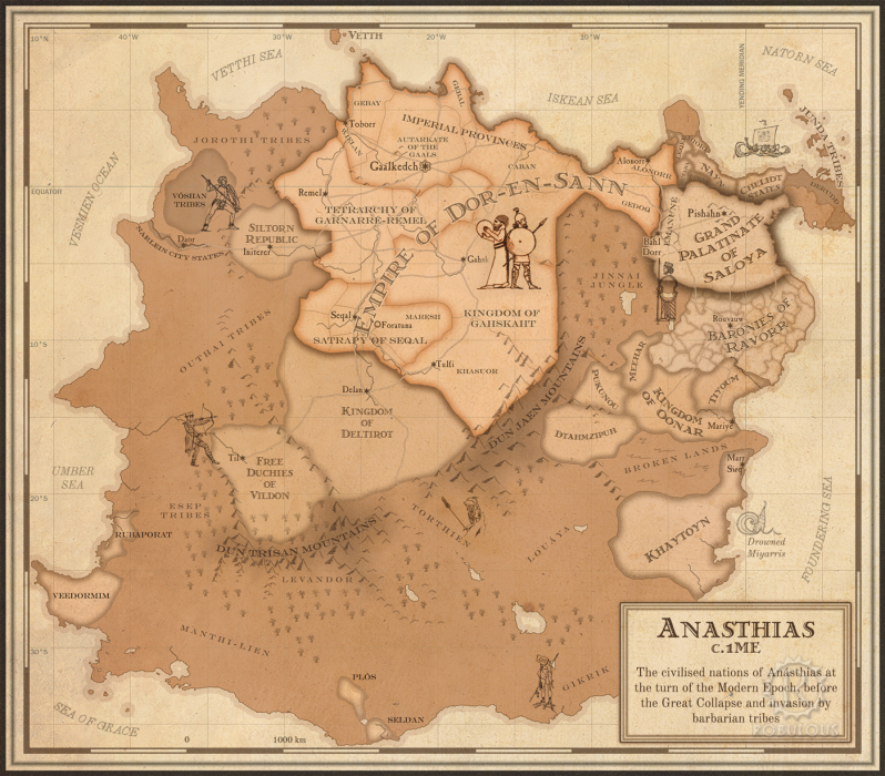
Atlas: Ancient Anásthias in the 1st Century ME

| Modern Political Mapplugin-autotooltip__small plugin-autotooltip_bigAtlas: Anásthias
[fmap-anasthias.png] * Zoom out * Holy Motherland of Ororr * Union of Harthera * Region of Otekahré * Region of Taur-dji-Oum * Region of Munatan * Zoom Out * Vetthi Republic
| Modern Political Map | Geography | Poster version | 1st Century History |
atlas
Anásthias
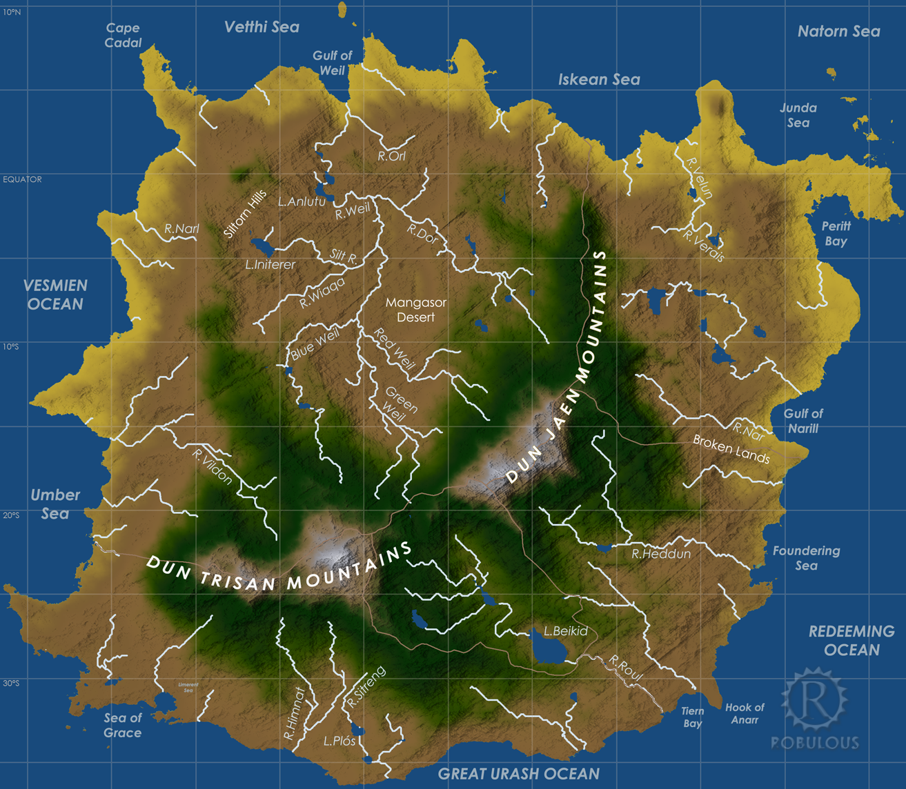
Anásthias [a-NAS-thee-ass / ænæsθiːæs], or [an-ass-THEE-as] is an equatorial island continent, heart of the Civilised World. The north straddles the equator and is hot and humid, while most o… | Geographyplugin-autotooltip__small plugin-autotooltip_bigAtlas: Anásthias Geographical Features
[map-anasthias_geog.png] * Zoom in * Zoom out * Ororr * Harthera| * Otekahré * torthien * Munatan * Zoom Out
| Modern Political Map | Geography | Poster version | 1st Century History | | Poster versionplugin-autotooltip__small plugin-autotooltip_bigAtlas: Anásthias (Poster version)
[Zoom out?]
Hover mouse/tap image to magnify
| Modern Political Map | Geography | Poster version | 1st Century History |
atlas
atlas | 1st Century Historyplugin-autotooltip__small plugin-autotooltip_bigAtlas: Ancient Anásthias in the 1st Century ME
[Zoom out?]
atlas
Anásthias
Anásthias [a-NAS-thee-ass / ænæsθiːæs], or [an-ass-THEE-as] is an equatorial island continent, heart of the Civilised World. The north straddles the equator and is hot and humid, while most of the equatorial centre is an upland plateau with fertile river valleys, and stretches of arid plains and desert in the shadow of the mountains. The south is temperate but more wild, separated from the civilisations of the north… |
Anásthias
Anásthias [a-NAS-thee-ass / ænæsθiːæs], or [an-ass-THEE-as] is an equatorial island continent, heart of the Civilised Worldplugin-autotooltip__small plugin-autotooltip_bigCivilised World
The Civilised World refers to the known regions of human civilisation, notably the continent of Anásthias, the Natorn Archipelago and surrounding islands.
Gastrinimer's 3rd century BME Map of the World, showing Anásthias and the Natorn Isles. Note: old maps place north to the right.AnásthiasAnásthiasAnásthiasAnásthias. The north straddles the equator and is hot and humid, while most of the equatorial centre is an upland plateau with fertile river valleys, and stretches of arid plains and desert in the shadow of the mountains. The south is temperate but more wild, separated from the civilisations of the north by the almost impassable Dun Trisanplugin-autotooltip__small plugin-autotooltip_bigDun Trisan
The Dun Trisan is a range of mountainous uplands in Anásthias, which divide Ororr to the north from the region of Munatan to the south. The Dun Trisan is the southerly extension of the great arc of mountains which divides Anásthias in two, the northerly section being the virid mountains. Politically the continent is dominated by two great powers: the sprawling theocratic state of Ororrplugin-autotooltip__small plugin-autotooltip_bigOrorr
Ororr [o-ROARR, ɒ̝rɔ'ɾ], also called the Holy Motherland of Ororr, is a theocratic nation in Anásthias, one of the world's great powers. It the largest nation in the world, perhaps the largest empire in history, occupying the entire northwest of the continent between the mountains and the sea. Ororrlanguagelanguagelanguage to the northwest, and the maritime empire of Hartheraplugin-autotooltip__small plugin-autotooltip_bigHarthera
The Hartheran Union, commonly named Harthera, is an imperialist maritime nation state dominating the northeast of Anásthias. It is one of the two great powers of the modern epoch, arguably the most technologically and militarily powerful nation in the world, only matched by the vast size and wealth of its neighbour, viridOrorrMEOrorrOrorrOrorrOrorr in the northeast, separated by the wall of the Dun Jaenplugin-autotooltip__small plugin-autotooltip_bigDun Jaën
The Dun Jaën [doon jay-ENN] is a mountain range in eastern Anásthias, the northern section of the great arc of mountains which, together with the southerly Dun Trisan, separates Ororr from the remainder of the continent.
The Dun Jaen consists of rugged mountains, including the tallest peaks in the mountains.

Regions:
- Hartheran Unionplugin-autotooltip__small plugin-autotooltip_bigHarthera
The Hartheran Union, commonly named Harthera, is an imperialist maritime nation state dominating the northeast of Anásthias. It is one of the two great powers of the modern epoch, arguably the most technologically and militarily powerful nation in the world, only matched by the vast size and wealth of its neighbour, viridOrorrMEOrorrOrorrOrorrOrorr - Motherland of Ororrplugin-autotooltip__small plugin-autotooltip_bigOrorr
Ororr [o-ROARR, ɒ̝rɔ'ɾ], also called the Holy Motherland of Ororr, is a theocratic nation in Anásthias, one of the world's great powers. It the largest nation in the world, perhaps the largest empire in history, occupying the entire northwest of the continent between the mountains and the sea. Ororrlanguagelanguagelanguage - Otekahréplugin-autotooltip__small plugin-autotooltip_bigOtekahré
Otekahré [oh-tek-AH-ray] (also called Anarthis in Harthera), is the southeastern region of Anásthias, lying south of Harthera and east of the Dun Jaen mountains. The region has no central governments, but the cities and polities are joined in a loose cultural and economic league, called HartheraOrorrviridHartheraOrorr - Taur-dji-oumplugin-autotooltip__small plugin-autotooltip_bigTaur-Dji-Oum
Taur-Dji-Oum [Tower-shjee-ohm], known as Torthien in much of the Civilised World, also called the Vale of Tortanis in Ororr, is an upland area of southeastern Anásthias. It is a politically complex and unstable region, consisting of twenty-three major ethnic nations, territorially sub-divided into smaller kingdoms, chiefdoms, fiefdoms and clan holdings, with a shifting pattern of allegiances and alliances. - Munatanplugin-autotooltip__small plugin-autotooltip_bigMunatan
Munatan [Moo-Nah-Tahn] is the southernmost region of Anásthias, south of the Dun Trisan mountains. The name possibly derives from a ancient Thalsic, meaning “Land of One Sun”, since the daystar is not visible in the southern hemisphere. Or it may be a reference to the Manthi people who were once the majority population of western Munatan. The term is an OrorrOrorrOrorrHartheraHartheraOrorrOrorrOrorrHartheraHartheraHartheran
Etymology
The ancient Miyarrainplugin-autotooltip__small plugin-autotooltip_bigMiyarrain People
The Miyarrain were the inhabitants of ancient Miyarris, famed as the most advanced civilisation of the Celadon Epoch. The Miyarrain were the progenitors of all modern Eloyoun peoples throughout eastern Anásthias.
Ancient Miyarris
This is in a series of articles about the ancient civilisation of called the continent Shahmuzroo, meaning “home island”, but the Iskeanplugin-autotooltip__small plugin-autotooltip_bigIskean People
The Iskean are an East Thalsic people primarily inhabiting the northeastern coastal regions of Anásthias. Today they are one of the major ethnic groups of Harthera, with Iskean populations also found in the eastern coastal provinces of Ororr, as well as islands in the Anas Thias, meaning “the great land”, is now the standard term.
Geography
Anásthias is approximately 7100 km north to south, covering 44 degrees of latitude. The north coast lies just north of the equator, central parts being tropical and the far south of Munatanplugin-autotooltip__small plugin-autotooltip_bigMunatan
Munatan [Moo-Nah-Tahn] is the southernmost region of Anásthias, south of the Dun Trisan mountains. The name possibly derives from a ancient Thalsic, meaning “Land of One Sun”, since the daystar is not visible in the southern hemisphere. Or it may be a reference to the Manthi people who were once the majority population of western Munatan. The term is an OrorrOrorrOrorrHartheraHartheraOrorrOrorrOrorrHartheraHartheraHartheran in the cooler temperate zone. It is surrounded by ocean on all sides, being at least five thousand kilometres from any other continental landmass. It is roughly rectangular in shape, dominated by two great mountain ranges which divide the continent in a great curve from northeast to southwest, the Dun Jaenplugin-autotooltip__small plugin-autotooltip_bigDun Jaën
The Dun Jaën [doon jay-ENN] is a mountain range in eastern Anásthias, the northern section of the great arc of mountains which, together with the southerly Dun Trisan, separates Ororr from the remainder of the continent.
The Dun Jaen consists of rugged mountains, including the tallest peaks in the mountains being in the north and the Dun Trisanplugin-autotooltip__small plugin-autotooltip_bigDun Trisan
The Dun Trisan is a range of mountainous uplands in Anásthias, which divide Ororr to the north from the region of Munatan to the south. The Dun Trisan is the southerly extension of the great arc of mountains which divides Anásthias in two, the northerly section being the virid to the west.
Regions
Geopolitically it is divided into five regions which are geographically and ethnolinguistically discrete. Northwest of the great mountain ranges lies the vast theocratic nation-state of Ororrplugin-autotooltip__small plugin-autotooltip_bigOrorr
Ororr [o-ROARR, ɒ̝rɔ'ɾ], also called the Holy Motherland of Ororr, is a theocratic nation in Anásthias, one of the world's great powers. It the largest nation in the world, perhaps the largest empire in history, occupying the entire northwest of the continent between the mountains and the sea. Ororrlanguagelanguagelanguage, the largest, most populous and wealthiest nation in the world, encompassing a third of the continent. In the northeast is Hartheraplugin-autotooltip__small plugin-autotooltip_bigHarthera
The Hartheran Union, commonly named Harthera, is an imperialist maritime nation state dominating the northeast of Anásthias. It is one of the two great powers of the modern epoch, arguably the most technologically and militarily powerful nation in the world, only matched by the vast size and wealth of its neighbour, viridOrorrMEOrorrOrorrOrorrOrorr, a maritime imperial nation, arguably the most technically advanced and militarily powerful in the world.
South of Harthera is Otekahréplugin-autotooltip__small plugin-autotooltip_bigOtekahré
Otekahré [oh-tek-AH-ray] (also called Anarthis in Harthera), is the southeastern region of Anásthias, lying south of Harthera and east of the Dun Jaen mountains. The region has no central governments, but the cities and polities are joined in a loose cultural and economic league, called HartheraOrorrviridHartheraOrorr, a region with many nomadic tribes and independent communities with no central government. Most of the coastal region is Kahtoynplugin-autotooltip__small plugin-autotooltip_bigKahtoyn
Kahtoyn (called Bhourdan in Hartraan), also called the Confederation of Kahtoyn, is a political entity in the region of Otekahré. It is unique in the world that it is not a nation in the true sense, since it has no formal governmental structures, no kings or governors, no military or police, no codified laws, prisons or justice system. Instead it is made up of thousands of self-governing polities who follow a common ideology of good behaviour, common standards, and (mostly) friendly com…, a fertile crescent of greenplugin-autotooltip__small plugin-autotooltip_bigGreen
The Green Kingdom of flora and fauna includes humans, mammals, birds, whales, greenfish, and most green plants and crops cultivated by humankind. land surrounded by plains, jungle and the foothills of the Dun Jaen.
South of the Dun Trisan mountains is Munatanplugin-autotooltip__small plugin-autotooltip_bigMunatan
Munatan [Moo-Nah-Tahn] is the southernmost region of Anásthias, south of the Dun Trisan mountains. The name possibly derives from a ancient Thalsic, meaning “Land of One Sun”, since the daystar is not visible in the southern hemisphere. Or it may be a reference to the Manthi people who were once the majority population of western Munatan. The term is an OrorrOrorrOrorrHartheraHartheraOrorrOrorrOrorrHartheraHartheraHartheran, a cooler and wilder region traditionally isolated from the great powers of the north, made up of many city states and nations.
History
There is little recorded history about the earliest settlement of the continent, but the most ancient civilisations were centred in the northeast of the government, during the Jade Epochplugin-autotooltip__small plugin-autotooltip_bigJade Epoch
Period of world history circa 11,000-6000 BME, sometimes called the Stone Age. from around 6000 BMEplugin-autotooltip__small plugin-autotooltip_bigBME (Before Modern Epoch)
Used to date years Before the Modern Epoch., when the sea level was much lower. Human civilisation thence spread westward along the coast of modern Ororrplugin-autotooltip__small plugin-autotooltip_bigOrorr
Ororr [o-ROARR, ɒ̝rɔ'ɾ], also called the Holy Motherland of Ororr, is a theocratic nation in Anásthias, one of the world's great powers. It the largest nation in the world, perhaps the largest empire in history, occupying the entire northwest of the continent between the mountains and the sea. Ororrlanguagelanguagelanguage, and south. Settlement of the inland regions spread more slowly because of the challenge of dense viridplugin-autotooltip__small plugin-autotooltip_bigVirid
Referring to the Virid Kingdom of flora and fauna, toxic to human life. vegetation, although the Wiyel Valleyplugin-autotooltip__small plugin-autotooltip_bigRiver Wiyel
The River Wiyel or Weil [WILE, WAH-yil] in Ororr is the longest river in the Civilised World. The Wiyel Basin drains two thirds of modern Ororr, running over 5000 km from its source in the southern Dun Trisan mountains, flowing northwards to the sea.
Names
As the river is so long it has been known by many names by different civilisations throughout history. 'Wiel' is the name used during the time of the GreenOrorr became an important centre of population. There is also evidence of very ancient habitation in Torthienplugin-autotooltip__small plugin-autotooltip_bigTorthien
Torthien is a common but now outdated term for the region of Taur-Dji-Oum, particularly used in Harthera. and the sheltered upper valleys, which in those times would have been free of viridplugin-autotooltip__small plugin-autotooltip_bigVirid
Referring to the Virid Kingdom of flora and fauna, toxic to human life. forest and perhaps more easily settled.