


Li-Vam-Aur
Li-Vam-Aur [lee-vbam-our], often known by its Ororranplugin-autotooltip__small plugin-autotooltip_bigOrorr
Ororr [o-ROARR, ɒ̝rɔ'ɾ], also called the Holy Motherland of Ororr, is a theocratic nation in Anásthias, one of the world's great powers. It the largest nation in the world, perhaps the largest empire in history, occupying the entire northwest of the continent between the mountains and the sea. Ororrlanguagelanguagelanguage name Levandor, is an upland nation in the Dun Trisanplugin-autotooltip__small plugin-autotooltip_bigDun Trisan
The Dun Trisan is a range of mountainous uplands in Anásthias, which divide Ororr to the north from the region of Munatan to the south. The Dun Trisan is the southerly extension of the great arc of mountains which divides Anásthias in two, the northerly section being the virid mountains of Anásthiasplugin-autotooltip__small plugin-autotooltip_bigAnásthias
Anásthias [a-NAS-thee-ass / ænæsθiːæs], or [an-ass-THEE-as] is an equatorial island continent, heart of the Civilised World. The north straddles the equator and is hot and humid, while most of the equatorial centre is an upland plateau with fertile river valleys, and stretches of arid plains and desert in the shadow of the mountains. The south is temperate but more wild, separated from the civilisations of the north by the almost impassable Harthera. It is remote and sparsely populated.
Munatanplugin-autotooltip__small plugin-autotooltip_bigMunatan (Category)
Articles about Munatan, the far southern region of Anásthias.
Nations
Cities
topics regi1
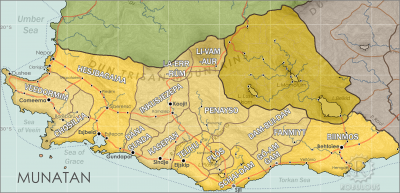 Hover mouse to see more detail | Go to full atlas mapplugin-autotooltip__small plugin-autotooltip_bigAtlas: Munatan
[munatan.png] * Zoom out * East Munatan * West Munatan
Munatan
Munatan [Moo-Nah-Tahn] is the southernmost region of Anásthias, south of the Dun Trisan mountains. The name possibly derives from a ancient OrorrOrorrOrorrHartheraHartheraOrorrOrorrOrorrHartheraHartheraHartheran
This is in a series of articles about Munatanplugin-autotooltip__small plugin-autotooltip_bigMunatan
Munatan [Moo-Nah-Tahn] is the southernmost region of Anásthias, south of the Dun Trisan mountains. The name possibly derives from a ancient Thalsic, meaning “Land of One Sun”, since the daystar is not visible in the southern hemisphere. Or it may be a reference to the Manthi people who were once the majority population of western Munatan. The term is an OrorrOrorrOrorrHartheraHartheraOrorrOrorrOrorrHartheraHartheraHartheran, the temperate region of southern Anásthiasplugin-autotooltip__small plugin-autotooltip_bigAnásthias
Anásthias [a-NAS-thee-ass / ænæsθiːæs], or [an-ass-THEE-as] is an equatorial island continent, heart of the Civilised World. The north straddles the equator and is hot and humid, while most of the equatorial centre is an upland plateau with fertile river valleys, and stretches of arid plains and desert in the shadow of the mountains. The south is temperate but more wild, separated from the civilisations of the north by the almost impassable Harthera.
Despite its remoteness it is one of the most ancient regions of continuous human habitation, perhaps because in prehistory it was relatively clear of virid life, unable to tolerate the thinner mountain air and cool climate. It shares a close cultural and ethnic affinity with the neighbouring region of Taur-Dji-Aumplugin-autotooltip__small plugin-autotooltip_bigTorthien
Torthien is a common but now outdated term for the region of Taur-Dji-Oum, particularly used in Harthera. (Torthien), but Li-Vam is a much more ancient, spiritual and isolated region.
The principle area of human habitation is the region of Jo-van-koplugin-autotooltip__small plugin-autotooltip_bigJo-van-ko
Jo-van-ko is the central inhabited region of Li-Vam-Aur in the mountainous uplands of the Dun Trisan.
Munatan
Hover mouse to see more detail | Go to full atlas map
This is in a series of articles about Munatan, the temperate region of southern Anásthias.
munatan, a large bowl-shaped plateau encircled mountains. Here are grown the limited number of cropsplugin-autotooltip__small plugin-autotooltip_bigCrops
List of food crops grow for human consumption
topics that can grow at such altitude, awmplugin-autotooltip__small plugin-autotooltip_bigAwm
Awm is a grain crop farmed in cooler and upland climates throughout the Civilised World, particularly the highlands of central Anásthias. It is the staple food of Torthien and upland parts of Munatan.
Food and Drink
This is in a series of articles about Food and Drink.
Awm is a grassy green plant which yields clusters of ovoid seeds roughly 0.8mm in length, ranging in colour from off-white to red or occasionally black, with a thick husk and a chewy innard. Red awm is colloquially cal… being the staple food of the region. Orrisplugin-autotooltip__small plugin-autotooltip_bigOrris
Orris is a grassy green plant with characteristic green-gold leaves and seeds. Orris is common grain food, eaten throughout Anásthias.
Food and Drink
This is in a series of articles about Food and Drink.
Orris grows in well in a variety of soils, from well-drained temperate to marshy areas, the amount of available moisture determining the size of the crop. It is moderately tolerant to salt, so is often a staple of peoples living in coastal areas subject to, doughberryplugin-autotooltip__small plugin-autotooltip_bigDoughberry
Doughberry is a green cereal plant cultivated for its seeds, which grow in clusters of spherical grains about 8mm in diameter. Freshly picked doughberries can be eaten raw, but more commonly are dried in the sun and rehydrated in hot water as a nutritious accompaniment to meals, where they have a soft, slightly chewy texture.Ororr and other crops are also grown.
Li-Vam-Aur is generally considered to be in the region of Munatanplugin-autotooltip__small plugin-autotooltip_bigMunatan
Munatan [Moo-Nah-Tahn] is the southernmost region of Anásthias, south of the Dun Trisan mountains. The name possibly derives from a ancient Thalsic, meaning “Land of One Sun”, since the daystar is not visible in the southern hemisphere. Or it may be a reference to the Manthi people who were once the majority population of western Munatan. The term is an OrorrOrorrOrorrHartheraHartheraOrorrOrorrOrorrHartheraHartheraHartheran, though culturally it is more closely associated with Taur-Dji-Aum.