Atlas: Kingdom of Narette

Kingdom of Narette
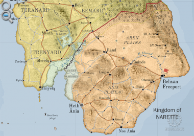
The Kingdom of Narette, or Naret [na-RET, na rɛt] (arch. Anret or Anrette), is a modern nation occupying the southern half of the largest islandplugin-autotooltip__small plugin-autotooltip_bigMainland
Mainland is the largest of the three major Anrel Isles. Politically it is divided between the two nations of Trésard and Anret.
Anrel
Hover/tap image to magnify | Go to world atlas
This is in a series of articles about the Anrel Isles, a significant archipelago in the Natorn Sea.
The name Mainland is rarely used, except by the inhabitants of smaller outlying islands, particuarly those living on in the Anrel Islesplugin-autotooltip__small plugin-autotooltip_bigAnrel Isles
Alternate name for Anrel.. Before the Orphans Warplugin-autotooltip__small plugin-autotooltip_bigOrphans War
Alternative name for the Long War.
redirects it was called the Kingdom of Anrette.
Naretteplugin-autotooltip__small plugin-autotooltip_bigNarette (Category)
Articles related to the Kingdom of Narette in the Anrel Isles.
All topics
Cities
anrel nati1 topics
 plugin-autotooltip__small plugin-autotooltip_bigAtlas: Kingdom of Narette
[fmap-narette.png] * Zoom in * Zoom out
* @ * @ * @ * @ * @ * @ * @ * @ * @ * @
atlas nationmaps
Kingdom of Narette
The Kingdom of Narette, or Naret [na-RET, na rɛt] (arch. Anret or Anrette), is a modern nation occupying the southern half of the largest island in the AnrelAnrelAnrelAnrelAnrelAnrel
This is in a series of articles about the Kingdom of Naretteplugin-autotooltip__small.
- Name: Kingdom of Narette
- Demonym: Naretian [na-REE-shun]
- Government: Hexactic Monarchyplugin-autotooltip__small plugin-autotooltip_bigHexact Doctrine
The Hexact Doctrine is a philosophy of government developed in Anrel in the early 3rd century ME, with the aim of creating governments that benefited the health, wealth and wellbeing of its citizens. It is the model for many governments throughout the MEAnrelAnrelAnrelAnrelAnrelAnrelAnrel - Capital: Heth Aniaplugin-autotooltip__small plugin-autotooltip_bigHeth Ania
Heth Ania [HETH AH-nee-uh] is the royal capital of the Kingdom of Narette. It is a modern and cosmopolitan city, centre for sea trade between Narette and Trésard.
History
Settlements have existed in the area throughout recorded history, but the first city was built as a colony of the Annéans in the second millenium ME - Currency: Hexactic Almplugin-autotooltip__small plugin-autotooltip_bigHexactic Alm
The Hexactic Alm [ARM] is the official currency of the nations of Anrel, accepted throughout the Natorn Archipelago. An alm is worth six pins, and 24 alms are a crown.
Money
[ ]
This is in a series of articles about money, currencies and finance.
The alm originally a food token given to refugees during the Anrel, Naretian Crown - Foundation: 215 MEplugin-autotooltip__small plugin-autotooltip_bigModern Epoch (ME)
The Modern Calendar is a dating system acknowledged throughout the Civilised World. It numbers years from the Modern Epoch, abbreviated ME and BME (Before Modern Epoch). It is also called the Modern Era.
Calendar
This is in a series of articles about calendars and dating systems.OrorrHartheraHMOrorrHartheraOrorrOrorrHMHartheraHMHartheraOrorr - Language: Rettienplugin-autotooltip__small plugin-autotooltip_bigRettien
Rettien is an Aralsic language spoken in Narette in the Anrel Isles. Although it shares much common vocabulary with Reidan, Rettien is heavily influenced by Old Oracilem, the Iskean language of the former city-state of Oracil.
Language
language
This is in a series of articles about Languages and Communication.
Rettien has two distinct dialects. High Rettien is the languagelanguagelanguagelanguage
The majority of the population live on the fertile hills of the Ania Plateauplugin-autotooltip__small plugin-autotooltip_bigAnia Plateau
The Ania Plateau [AH-nee-uh, 'ɑːniə] is an upland plateau in the southwest of Narette, in the Anrel Isles. The land is fertile and well-drained, home to the majority of Narette's population and agriculture.
The easiest route up to the Plateau is via Binid in the south, where the escarpment is much lower, and a succession of low slopes make vehicle traffic much easier to traverse., while the north of the kingdom is grassland plain and mountains. Though since the war it officially espouses the Commonwealth ideals of the Hexact Doctrineplugin-autotooltip__small plugin-autotooltip_bigHexact Doctrine
The Hexact Doctrine is a philosophy of government developed in Anrel in the early 3rd century ME, with the aim of creating governments that benefited the health, wealth and wellbeing of its citizens. It is the model for many governments throughout the MEAnrelAnrelAnrelAnrelAnrelAnrelAnrel, Narette remains a hereditary monarchy.
Narette was one of the combatants in the Long Warplugin-autotooltip__small plugin-autotooltip_bigLong War
The Long War (219-263 ME) was the bloodiest conflict in the history of the Anrel Isles, between the allied city-states of the Northern League (now the kingdoms of Trésard and Sensatard), and the Kingdom of Narette. It is often bitterly called the Orphans' War, since it went on so long it was fought by two generations of people whose own parents had been killed in the war.viridAnrelmagicAnrelAnrel, which saw the destruction of most settlements in the northern plains and environment devastation of what was once fertile farmland.
Name
Narette derives from the languageplugin-autotooltip__small plugin-autotooltip_bigLanguages
List of human languages and dialects, contemporary and extinct.
Language
language
This is in a series of articles about Languages and Communication.
topics sidebar cult1 of Oracilemplugin-autotooltip__small plugin-autotooltip_bigOracil
Oracil was a historic city-state in the east of modern Narette in the Anrel Isles, in the foothills of the Laharkin Mountains. Oracil is thought to have been founded by an Iskean-ethnic tribe around 1100 BME. The city grew rich on the fertile soils surrounding Mount Oracil, as well as mines burrowed deep into the mountains of the, ann-red meaning “neighbouring land”, the lands west of Oracil. This became Anret, the general name for the south of the Anrelplugin-autotooltip__small plugin-autotooltip_bigAnrel Isles
Anrel [ANN-rel], or the Anrel Isles, is the most northerly island group in the Natorn Archipelago. It consists of three major islands and numerous smaller ones. The largest, colloquially if infrequently called Mainland, is divided between the kingdoms of Trésard and Narette. The island Isles up until the Long War. It was pronounced “An-Na-ret” in the local dialect, but after the war the kingdom was officially named Narette, reflecting a shift in pronunciation.
Geography
Narette has the warmest climate in Anrel, sheltered from prevailing rain storms and much drier than the north. The southern plateau has the densest population and agriculture with a warm maritime climate, while the central and northern half of the nation is relatively sparsely populated.
The land is divided into three geographical regions. The northeast is mountainous uplands with sparse viridplugin-autotooltip__small plugin-autotooltip_bigVirid
Referring to the Virid Kingdom of flora and fauna, toxic to human life. vegetation, dominated by the huge Laharkin Rangeplugin-autotooltip__small plugin-autotooltip_bigLaharkin Range
Common name for the Laharkin Mountains in Anrel. which runs the length of the east coast of the island. The highest peak is the volcanic Mount Arentplugin-autotooltip__small plugin-autotooltip_bigMount Arént
Mount Arént [a-RENT] is a volcanic mountain in the Laharkin Range, in the north of Narette. It is the highest mountain and the largest volcano in the Natorn Archipelago. anret
The volcano has been dormant for most of human history, though there are fumaroles and occasional earth tremors in the region. There have been some serious earthquakes, most famously the earthquake of 678, which has been dormant for the last fifteen hundred years, but occasionally rumbles creating earthquakes and landslides.
The south half of the country is the Ania Plateauplugin-autotooltip__small plugin-autotooltip_bigAnia Plateau
The Ania Plateau [AH-nee-uh, 'ɑːniə] is an upland plateau in the southwest of Narette, in the Anrel Isles. The land is fertile and well-drained, home to the majority of Narette's population and agriculture.
The easiest route up to the Plateau is via Binid in the south, where the escarpment is much lower, and a succession of low slopes make vehicle traffic much easier to traverse., the richest and most densely populated region of Narette. The Plateau is a chunk of land raised up by being squeezed between two fault lines, creating towering cliffs at the shore, and a high escarpment on the landward side. The Plateau receives moderate rainfall, the north half being hilly, the south and centre being fertile riverland. The Plateau is entirely greenplugin-autotooltip__small plugin-autotooltip_bigGreen
The Green Kingdom of flora and fauna includes humans, mammals, birds, whales, greenfish, and most green plants and crops cultivated by humankind., having been long since picked clean of viridplugin-autotooltip__small plugin-autotooltip_bigVirid
Referring to the Virid Kingdom of flora and fauna, toxic to human life. life. Rivers run into the fertile central basin, running northwards into the tributaries of the River Minndplugin-autotooltip__small plugin-autotooltip_bigRiver Minnd
The River Minnd [MINN-d] (also Minde [MIN-duh]) is the principle river of Narette in the Anrel Isles. Due to the unique geography of the Ania Plateau, it flows from its source northwards over the Minnd Falls to the plains, where it curves southeastward to the sea at, which plunges over the escarpment onto the plain beneath.
Between the plateau and the mountains lies the central plains. Being in the rain shadow of two upland regions, it receives little rainfall and is arid, a mixture of greenplugin-autotooltip__small plugin-autotooltip_bigGreen
The Green Kingdom of flora and fauna includes humans, mammals, birds, whales, greenfish, and most green plants and crops cultivated by humankind. grassland and virid scrubplugin-autotooltip__small plugin-autotooltip_bigVirid scrubland
Virid scrubland is a region where low-growing virid vegetation is the predominant life. Scrubland is often the result of thin poor soils and low rainfall. It can also be an intermediate landscape in areas destroyed by fire.
Flora
herbs
This is in a series of articles about except for cultivated areas along the river. There are some settlements along the river Minnd, surrounded by groves of limetaplugin-autotooltip__small plugin-autotooltip_bigLimeta
The limeta is a virid tree which grows in the tropical regions, particularly in northern and coastal Anásthias. The fruits are round with dark green leathery skin and distinctive red flesh. They are one of the few virid fruits grown for human consumption, havin a sweet and distinctively acrid taste. virid and other fruits, but it is otherwise sparsely inhabited, depopulated during the Long Warplugin-autotooltip__small plugin-autotooltip_bigLong War
The Long War (219-263 ME) was the bloodiest conflict in the history of the Anrel Isles, between the allied city-states of the Northern League (now the kingdoms of Trésard and Sensatard), and the Kingdom of Narette. It is often bitterly called the Orphans' War, since it went on so long it was fought by two generations of people whose own parents had been killed in the war.viridAnrelmagicAnrelAnrel. The fortified city of Randplugin-autotooltip__small plugin-autotooltip_bigRand
Rand is a fortified hill city in the central plains of Narette. It was the only major settlement in the plains not destroyed during the Long War, despite multiple assaults and seiges. It owes its survival to its position on a hill with unusually strong walls. During the war the outer city was sacked many times, the surviving inhabitants rebuilding their lives within the safety of the citadel. is the only city, and a significant military garrison.
Belisanplugin-autotooltip__small plugin-autotooltip_bigBelisan Freeport
The city of Belisan [beh-li-SAN], known internationally as Belisan Freeport, is a port city surrounding Belisan Bay, at the mouth of the River Minnd in southeast Anret.
Belisan is actually two cities divided by the river. Belisan City lies on the west of the river, with its Royal Docks subject to normal customs tariffs. East of the river is the, at the mouth of the Minnd on the southeast coast, surrounds a large natural harbour and as such is the most important port, not only in Narette but the whole Anrel Isles. Although there are ports on the Ania Plateau, the cliffs and narrow inlets make them unsuited to bulk cargo. Belisan Freeport is therefore the prime destination and home port for merchantmen trading between Anrel and the south.
Government
The state is nominally Hexactic Monarchyplugin-autotooltip__small plugin-autotooltip_bigHexact Doctrine
The Hexact Doctrine is a philosophy of government developed in Anrel in the early 3rd century ME, with the aim of creating governments that benefited the health, wealth and wellbeing of its citizens. It is the model for many governments throughout the MEAnrelAnrelAnrelAnrelAnrelAnrelAnrel, but the king is much more powerful than in neighbouring nations. Narette has the same system of aristocracyplugin-autotooltip__small plugin-autotooltip_bigAnrel Aristocracy
The Anrel Isles are governed by a class collectively called the Grafen or Graves, individually given the courtesy title Graf. Leaders of towns, cities, and even nations are drawn from this class. Traditionally, leaders are selected by will of the populace, based on their personal qualities and family merits, according to the traditional honour system of Anrel as the rest of the Isles, but the kingdom is more feudal than elsewhere in Anrel. In succession the rule of primogeniture applies, so that eldest sons generally inherit the throne, rather than the more traditional system of primentureplugin-autotooltip__small plugin-autotooltip_bigPrimenture
Primenture is a social structure found particularly in the Natorn Archipelago, used to determine social rank and leadership. Primenture means leadership by those who are perceived to have the most social capital, and therefore usually, though not always, the most able., with the most capable candidate being chosen by the Hexact Council with consent of the people.
In Narette the Council is responsible for levying and collecting taxes, formulating laws and advising on policy, but the king can raise taxes independently, and is able to enact emergency laws without recourse to the Hexact.
The Hexactic institutions in Narette are weak and act mostly in an advisory capacity, smoothing relations with the Hexacts of the north, doing the bureaucratic work of the kingdom, and occasionally being used as a cover for royal tyranny.
Naretian kings tend to be more authoritarian than their northern neighbours, particularly in matters of defence - a fact for which Naretians are curiously proud, though their kings have at times been despotic.
Currency
The official currency is the Naretian Crown, or Ceru, a golden coin with royal regalia, used particularly in large transactions. Silver Royals are circular coins used for smaller transactions.
The Hexactic Almplugin-autotooltip__small plugin-autotooltip_bigHexactic Alm
The Hexactic Alm [ARM] is the official currency of the nations of Anrel, accepted throughout the Natorn Archipelago. An alm is worth six pins, and 24 alms are a crown.
Money
[ ]
This is in a series of articles about money, currencies and finance.
The alm originally a food token given to refugees during the Anrel coin is disdained by the Naretian state, since it was originally issued by the Northern Leagueplugin-autotooltip__small plugin-autotooltip_bigNorthern League
The Northern League was a confederation of regions and city states in Anrasard (the landmass contiguous with the modern Anrel Isles, which united against the southern forces of Anret during the Long War.
Anrel
Hover/tap image to magnify | Go to world atlas
This is in a series of articles about the. However, in practice alm coins are the de facto everyday currency for the common people of Narette.
History
In ancient times the region formed the southern part of the Realm of the Godmenplugin-autotooltip__small plugin-autotooltip_bigRealm of the Godmen
The Realm of the Godmen was semi-mythic ancient civilisation, said to have existed in the Emerald Epoch from roughly 15,000-12,000 BME. It was the home of the mythical Godmen, the said to have been the first human civilisation from which all mankind descends. Godmen and its successor states. From the start of the Beryl Epochplugin-autotooltip__small plugin-autotooltip_bigBeryl Epoch
Historic epoch, age of the Empire of Dor-en-Sann. migrants from the southern isles began arriving. At first these were Asokwayplugin-autotooltip__small plugin-autotooltip_bigAsokway People
The Asokway are an Iskean-ethnic people living in the Natorn Archipelago and islands off the coast of Harthera. They are believed to be descendants of a breakaway or even proto-Iskean group who preferred to remain in the smaller islands of the archipelago rather than joining with the great civilisation of peoples who settled at first along the southern coast, but were displaced by later Iskeanplugin-autotooltip__small plugin-autotooltip_bigIskean People
The Iskean are an East Thalsic people primarily inhabiting the northeastern coastal regions of Anásthias. Today they are one of the major ethnic groups of Harthera, with Iskean populations also found in the eastern coastal provinces of Ororr, as well as islands in the migrants. The Asokway migrated inland and up the centre and east of Anrel, their descendants being particularly the nomadic herders of central Narette, villagers along the east coast of Trésard, and the Sarekéaplugin-autotooltip__small plugin-autotooltip_bigSarekéa
The Sarekéa [sa-ray-KAY-ah] are the “hill people” of the central uplands of Sensatard, the most northerly island of Anrel in the Natorn Archipelago. The Sarekéa are distinct from other Northlanders, with a distinct language and rich culture.
Sensatard
This is in a series of articles about the hill people of central Sensatardplugin-autotooltip__small plugin-autotooltip_bigKingdom of Sensatard
The Hexactic Kingdom of Sensatard is an island nation, the northernmost of the Anrel Isles and the northern tip of the Natorn Archipelago. Consequently it is colloquially called Northland, particularly by its inhabitants.
Sensatard
This is in a series of articles about the.
There is a long history of antagonism between Narette and the north, since the time of the so-called 'Dragon War'. Long ago the cities of the north allied to destroy the city of Oracil, the ancient cultural capital in the foothills of the volcanic Mount Arent, accusing it of slavery and other perversions. After the war, refugees from the city established a new kingdom - Narette. After long years of resentment, they struck out against the unholy city of Rasee (Rasia), provoking the bitter Long War which ravaged Anrel for twenty-four years. The war ended nine centuries ago, and the Wall separating the two nations has been open for nearly two centuries - but antagonism still runs deep. The kingdom was founded in 2492 HMplugin-autotooltip__small plugin-autotooltip_bigHirèrk Moonscale
The Hirèrk Moonscale [Hee-Rerrk] (HM) is a luni-solar calendar used at least since the time of Miyarris, which measures cycles based on the moons, solar years as well as the millennia-long cycles of global climate change. Today years HM are only seen in historic works and not considered accurate in historical accounts.epochHMHMBMEepochsepochsepochepochepochepochepochHMepochsMEME, c. Year 58 before the Hornum Calendar.
Etymology
In ancient times there were three states in the region: Anret, Erannplugin-autotooltip__small plugin-autotooltip_bigKingdom of Erann
Erann was a nation in the southern Anrel Isles in the second millennium BME. Its capital was the city of Rand, and at its height it controlled most of the central plains and hills of what is now Narette, including the cities of Eminde, Binid and Obanam.
Anrel
Hover/tap image to magnify |, and Oracilemplugin-autotooltip__small plugin-autotooltip_bigOracil
Oracil was a historic city-state in the east of modern Narette in the Anrel Isles, in the foothills of the Laharkin Mountains. Oracil is thought to have been founded by an Iskean-ethnic tribe around 1100 BME. The city grew rich on the fertile soils surrounding Mount Oracil, as well as mines burrowed deep into the mountains of the. After the destruction of Oracil in the Dragon Warplugin-autotooltip__small plugin-autotooltip_bigDragon War
The Dragon War (682-678 BME) was the first major conflict to engulf the entire Anrel Isles, in which a league of northern cities united against the city-state of Oracil in the southeast. By the end of the war Oracil had been utterly destroyed, laying a foundation of bitterness that has soured north-south relations ever since, and ultimately led to the magicAnrelgreenHM, Anret claimed the entire region as the Kingdom of Anrette. After the Long War this was changed to Narette to be more inclusive of all of the peoples of the south.