Atlas: Helevos (Equirectangular)

An interactive map of the world of Helevos. Click any area of the map to zoom in to more information. Use the magnifier buttons to zoom out to see more about the planet and solar system.

Zoom inZoom outRetzaykZahkdarretVuliméSouth PoleNatorn ArchipelagoVetthAzri IslesEastern IslesCrish and VargAnásthiasTsaykouiZetahburookPolassirn OceanBrumal DeepRedeeming OceanVesmien OceanGreat Urash Ocean
  • Zoom inplugin-autotooltip__small plugin-autotooltip_bigAtlas: Civilised World

    [fmap-civworld.png] * Zoom in * Zoom out * Azri Isles * Eastern Isles * Anásthias * Vetthi Republic @ * Crish & Varg @ * Natorn Archipelago * Polassirn Ocean * Great Urash Ocean * Brumal Deep * Redeeming Ocean * Retzayk * Tsaykoui * New Hartrah Colony * Zahkdarret * Hi-Li-Ven * Barrier Isles * South Pole * Orodien * Vesmien Ocean * North Pole

    Civilised World

    The Civilised World refers to the known regions of human civilisat…
  • Zoom outplugin-autotooltip__small plugin-autotooltip_bigAtlas: Moons of Helevos

    [atlas-moons.gif] * Zoom in * Zoom out Thea
  • Retzaykplugin-autotooltip__small plugin-autotooltip_bigAtlas: Retzayk

    [atlas-retzayk.png] * Zoom in * Zoom out

    * @ * @ * @ * @ * @ * @ * @ * @ * @ * @

    Retzayk

    Retzayk is a long, narrow continent approximately 4500 km east of Anásthias, separated from it by the Redeeming Ocean. It extends from the North Pole, crossing the equator and deep into the southern hemisphere.Anásthiasviridviridvirid
  • Zahkdarretplugin-autotooltip__small plugin-autotooltip_bigAtlas: Zahkdarret

    [atlas-zahkdarret.png] * Zoom out

    * @ * @ * @ * @ * @ * @ * @ * @ * @ * @

    Zahkdarret

    Zahkdarret is the largest continent of Helevos, encompassing most of the western hemisphere to the west and north of Anásthias.

    North polar projection of the Zahkdarret-Retzayk landmass
  • Vuliméplugin-autotooltip__small plugin-autotooltip_bigAtlas: Vulimé

    [vulime.png] * Zoom out * Great Urash Ocean

    Anásthias | Zahkdarret | Retzayk | Vulimé | South Pole

    Vulimé

    Vulimé, or Voulimay (in Mayápo), is an island continent far to the south and east of Anásthias, more than 10,000km distant. The continent stretches 8400km from 25°S to 75°S , from subtropical forest in the north to icey tundra in the south.
  • South Poleplugin-autotooltip__small plugin-autotooltip_bigAtlas: South Pole

    [south_pole.png] * Zoom out

    South Pole

    The South Pole region consists of a permanent cap of ice covering sea, numerous islands and one large island continent, mostly concealed within a pack of sea ice which encompasses latitudes from roughly 75°C to the pole. The ice also encompasses the southern tip of the continent of
  • Natorn Archipelagoplugin-autotooltip__small plugin-autotooltip_bigAtlas: Natorn Archipelago

    [fmap-natorn.png] * Zoom in * Zoom out * Anrel Isles * The Spines * Antyok * Besoa * Manok

    Natorn Archipelago

    The Natorn Archipelago, or the Natorn Isles [nah-TORN], is a chain of islands in the Natorn Sea. The islands are oceanic ridge running from the northeastern tip of Anásthias to the Anrel Isles. The ridge is an active geological fault, many of the islands being volcanic.Anásthias
  • Azri Islesplugin-autotooltip__small plugin-autotooltip_bigAtlas: Azri Isles

    [fmap-azri_isles.png] * Zoom in * Zoom out

    Azri Isles

    The Azri Isles are a group of volcanic islands in the cool southerly seas of the Great Urash Ocean, at a latitude of 54°S, over 3000 km south of Anásthias. By far the largest is Krotolat-ten-azri, followed by Mol-pon-azri, Nai-pan-azri, Sehera-pan-azriAnásthiasgreenviridgreenviridgreen
  • Eastern Islesplugin-autotooltip__small plugin-autotooltip_bigAtlas: Eastern Isles

    [easternisles.png] * Zoom out

    Eastern Isles (New Perech)

    The Eastern Isles, also called New Perech or the Spice Islands, are a tropical island group in the Redeeming Ocean at 13ºS, 3300 km from the mainland of Harthera, 4125 km from the port of Narillin. The islands have a highly diverse population of HartheranHartheranHartheranHartheranHartheraHartheran
  • Crish and Vargplugin-autotooltip__small plugin-autotooltip_bigCrish and Varg

    Crish and Varg is an island group over 900 km north of Cape Cadal, the most northwesterly point of Anásthias. It is named for the two largest islands, but the group includes six smaller islands plus rocky islets, many appearing and disappearing with the viridgreenlanguageOrorrTherist
  • Anásthiasplugin-autotooltip__small plugin-autotooltip_bigAtlas: Anásthias

    [fmap-anasthias.png] * Zoom out * Holy Motherland of Ororr * Union of Harthera * Region of Otekahré * Region of Taur-dji-Oum * Region of Munatan * Zoom Out * Vetthi Republic

    | Modern Political Map | Geography | Poster version | 1st Century History |

    atlas

    Anásthias

    Anásthias [a-NAS-thee-ass / ænæsθiːæs], or [an-ass-THEE-as] is an equatorial island continent, heart of the Civilised World. The north straddles the equator and is hot and humid, while most o…
  • Tsaykouiplugin-autotooltip__small plugin-autotooltip_bigAtlas: Tsaykoui

    [atlas-tsaykoui.png] * Zoom in * Zoom out

    * @ * @ * @ * @ * @ * @ * @ * @ * @ * @

    Tsaykoui

    Tsaykoui is a large island group on the eastern edge on the Redeeming Ocean, 5600 km southeast of the Hook of Anarr and 1600 km south of the southernmost tip of Retzayk. Their latitude extends from 33-43°S, the climate ranging from sub-tropical to temperate.
  • Zetahburookplugin-autotooltip__small plugin-autotooltip_bigAtlas: Zetahburook

    [atlas-zetahburook.png] * Zoom out

    * @ * @ * @ * @ * @ * @ * @ * @ * @ * @

    Zetahburook

    Zetahburook [zeh-TAH-boo-rook] is a large island continent to the west of Zahkdarret, approximately 9000 km east-west and 8500 km north-south. It forms part of the Zahkdarret-Retzayk supercontinent.
  • Polassirn Oceanplugin-autotooltip__small plugin-autotooltip_bigPolassirn Ocean

    The Polassirn Ocean is the most northerly of the four oceans surrounding the Civilised World. The ocean is deep and cold, with occasional sea ice on the far northern shores.

    It is rich with virid sea life. The shallow waters around the Natorn Archipelago are full of green fish and pelagic flora, as well as
  • Brumal Deepplugin-autotooltip__small plugin-autotooltip_bigBrumal Deep

    The Brumal Deep is an oceanic basin in the Polassirn Ocean, east of the Natorn Sea. The basin is a roughly circular area, which at nearly 9000 m is the deepest sea in the Civilised World. It has no greenfish so is not visited by fishermen or whales. It is considered a treacherous area for shipping, with mountainous waves particularly during the
  • Redeeming Oceanplugin-autotooltip__small plugin-autotooltip_bigRedeeming Ocean

    The Redeeming Ocean, historically known by it's Miyarrain name, the Poomué, separates the Civilised World from the eastern continent of Retzayk. It is 4500km across at its narrowest point. It has a number of small islands, the Eastern Isles being the only sizeable group.
  • Vesmien Oceanplugin-autotooltip__small plugin-autotooltip_bigVesmien Ocean

    The Vesmien Ocean is one of the four oceans surrounding the Civilised World, to the west of Anásthias. It extends as far north as Cape Cadal, and as far as Deshee Point in Veedormim in the south.

    The Vesmien is shallower than other oceans, a notable feature being the many reefs and shifting sand bars which present a hazard to shipping. Principle amongst these are the
  • Great Urash Oceanplugin-autotooltip__small plugin-autotooltip_bigGreat Urash Ocean

    The Great Urash Ocean is one of the four oceans surrounding the Civilised World. It's name derives from the Manthi word meaning southern.

    It extends south from Anásthias to the Icehorns of the south pole, and from Vulime in the east to Zahkdarret in the west. Its boundaries are somewhat vague, as its seas are not often travelled by ships from the Anásthias

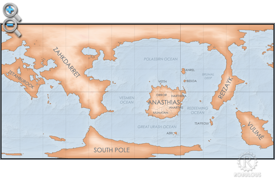
Anásthiasplugin-autotooltip__small plugin-autotooltip_bigCivilised World

The Civilised World refers to the known regions of human civilisation, notably the continent of Anásthias, the Natorn Archipelago and surrounding islands.

Gastrinimer's 3rd century BME Map of the World, showing Anásthias and the Natorn Isles. Note: old maps place north to the right.AnásthiasAnásthiasAnásthiasAnásthias
| Zahkdarretplugin-autotooltip__small plugin-autotooltip_bigZahkdarret

Zahkdarret is the largest continent of Helevos, encompassing most of the western hemisphere to the west and north of Anásthias.

North polar projection of the Zahkdarret-Retzayk landmass, showing the average range of north polar ice

In Mayapo it means “
| Retzaykplugin-autotooltip__small plugin-autotooltip_bigRetzayk

Retzayk is a long, narrow continent approximately 4500 km east of Anásthias, separated from it by the Redeeming Ocean. It extends from the North Pole, crossing the equator and deep into the southern hemisphere.

retzayk

Eastern continent of Retzayk

According to contemporary geography, Retzayk is believed to be one of the Anásthiasviridviridvirid
| Vuliméplugin-autotooltip__small plugin-autotooltip_bigVulimé

Vulimé, or Voulimay (in Mayápo), is an island continent far to the south and east of Anásthias, more than 10,000km distant. The continent stretches 8400km from 25°S to 75°S , from subtropical forest in the north to icey tundra in the south.

vulime

Geologically it was once connected to
| South Poleplugin-autotooltip__small plugin-autotooltip_bigSouth Pole

The South Pole region consists of a permanent cap of ice covering sea, numerous islands and one large island continent, mostly concealed within a pack of sea ice which encompasses latitudes from roughly 75°C to the pole. The ice also encompasses the southern tip of the continent of

 
maps/start-old.txt · Last modified: 2021/09/25 10:08 by Robert How · []