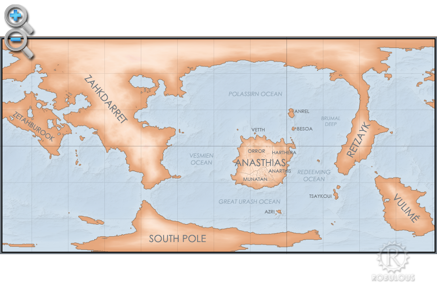
Atlas: Helevos (Equirectangular)
An interactive map of the world of Helevos. Click any area of the map to zoom in to more information. Use the magnifier buttons to zoom out to see more about the planet and solar system.

Anásthiasplugin-autotooltip__small plugin-autotooltip_bigCivilised World
The Civilised World refers to the known regions of human civilisation, notably the continent of Anásthias, the Natorn Archipelago and surrounding islands.
Gastrinimer's 3rd century BME Map of the World, showing Anásthias and the Natorn Isles. Note: old maps place north to the right.AnásthiasAnásthiasAnásthiasAnásthias | Zahkdarretplugin-autotooltip__small plugin-autotooltip_bigZahkdarret
Zahkdarret is the largest continent of Helevos, encompassing most of the western hemisphere to the west and north of Anásthias.
North polar projection of the Zahkdarret-Retzayk landmass, showing the average range of north polar ice
In Mayapo it means “ | Retzaykplugin-autotooltip__small plugin-autotooltip_bigRetzayk
Retzayk is a long, narrow continent approximately 4500 km east of Anásthias, separated from it by the Redeeming Ocean. It extends from the North Pole, crossing the equator and deep into the southern hemisphere.
retzayk
Eastern continent of Retzayk
According to contemporary geography, Retzayk is believed to be one of the Anásthiasviridviridvirid | Vuliméplugin-autotooltip__small plugin-autotooltip_bigVulimé
Vulimé, or Voulimay (in Mayápo), is an island continent far to the south and east of Anásthias, more than 10,000km distant. The continent stretches 8400km from 25°S to 75°S , from subtropical forest in the north to icey tundra in the south.
vulime
Geologically it was once connected to | South Poleplugin-autotooltip__small plugin-autotooltip_bigSouth Pole
The South Pole region consists of a permanent cap of ice covering sea, numerous islands and one large island continent, mostly concealed within a pack of sea ice which encompasses latitudes from roughly 75°C to the pole. The ice also encompasses the southern tip of the continent of
