River Wiyel
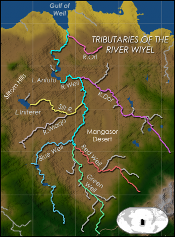
The River Wiyel or Weil [WILE, WAH-yil] in Ororr is the longest river in the Civilised World. The Wiyel Basin drains two thirds of modern Ororrplugin-autotooltip__small plugin-autotooltip_bigOrorr
Ororr [o-ROARR, ɒ̝rɔ'ɾ], also called the Holy Motherland of Ororr, is a theocratic nation in Anásthias, one of the world's great powers. It the largest nation in the world, perhaps the largest empire in history, occupying the entire northwest of the continent between the mountains and the sea. Ororrlanguagelanguagelanguage, running over 5000 km from its source in the southern Dun Trisan mountains, flowing northwards to the sea.

Names
As the river is so long it has been known by many names by different civilisations throughout history. 'Wiel' is the name used during the time of the Empire of Dor-en-Sann, though Wiyel is the modern spelling.
The name's origin is obscure, though may derive from Gyeil, as the river was incorrectly believed to flow from the far southwest, the homeland of the Gyeil people.
The Ororran church-state recognises the following official names for sections and tributaries of the vast river:
- Lower Wiyel - from the Tibooyo Cascades to the sea
- Greater Wiyel - from the Triminot Lakes to the sea.
- Green Wiyel or Tee - flowing from Deltirot, south of Niseq
Geography
The Wiyel Basin encompasses a vast area of central Anásthiasplugin-autotooltip__small plugin-autotooltip_bigAnásthias
Anásthias [a-NAS-thee-ass / ænæsθiːæs], or [an-ass-THEE-as] is an equatorial island continent, heart of the Civilised World. The north straddles the equator and is hot and humid, while most of the equatorial centre is an upland plateau with fertile river valleys, and stretches of arid plains and desert in the shadow of the mountains. The south is temperate but more wild, separated from the civilisations of the north by the almost impassable Harthera, draining almost a third of the entire continent, including all the northerly and westerly outflows from the Dun Jaen and Dun Trisan mountains. The river extends from its marshy estuary at Toborr in the north to Seqal in the south, where it branches into three distinct branches. These are officially termed the Blue Wiyel, Green Wiyel and Red Wiyel.
The Blue is wide and flat, meandering through the wide valley of the Riverlands with its numerous lakes and cataracts making navigation difficult. The Green Wiyel flows through the upland plateau of Deltirot with its abundant farming and horticulture, before plummeting over the Cataos Falls. The Red Wiyel is the eastern branch, flowing through the stark Red Wiyel Gorge on the margins of the Mangasor Desert.
Significance
The river not has only a huge economic and cultural significance in modern Ororr, but also a religious one. Since ancient times the river has been an artery of greenplugin-autotooltip__small plugin-autotooltip_bigGreen
The Green Kingdom of flora and fauna includes humans, mammals, birds, whales, greenfish, and most green plants and crops cultivated by humankind. life, sacred to all cultures from the ancient Issid, the Ensanni, and even in modern times. Believers in the Mother Church are encouraged to take the Shouft, the pilgrimage at least once in their lifetime, following the Great Prophet's historic journey from Toborr upriver by boat, via the holy cities of Remel and Seqal, to the shrine of Foratuna, in the Maresh Hills overlooking the Mangasor desert.
