Welcome to Helevos

plugin-autotooltip__small plugin-autotooltip_bigAtlas: Helevos interactive map

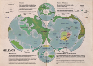
[fmap-hemispheres.png] * Zoom in * Zoom out * Planets * Moons * North Pole * South Pole * The Obverse * The Civilised World

Physical/Political map of Helevos. Click red flags to zoom in, or nav buttons to zoom out

< Historical world map

atlas

Helevos

Helevos (also known as Vos, or Veeos) is a temperate terrestrial world, fourth planet of the star Cordes in the viridgreenAnásthiasAnásthiasAnásthiasgreen

- Click for interactive world map

Helevosplugin-autotooltip__small plugin-autotooltip_bigHelevos

Helevos (also known as Vos, or Veeos) is a temperate terrestrial world, fourth planet of the star Cordes in the Cronox binary star system. The stars Cordes and Arjos are distant binaries, so on Helevos, Arjos is only seen in the northern hemisphere as star, sometimes bright enough to be seen during the day, circling roughly over the viridgreenAnásthiasAnásthiasAnásthiasgreen
is a fantasy world of magicplugin-autotooltip__small plugin-autotooltip_bigMagic

In common terms, magic is the art of producing a desired outcome through occult means. Various arts are described as magical, from common street illusionists, village herbalists, and rituals for the intercession of deities. However, true magic is the art and science of elemental mastery, harnessing elemental creatures and instructing them to perform simple or complex tasks.
and science, divided by two incompatible biologies: the Green Kingdomplugin-autotooltip__small plugin-autotooltip_bigGreen

The Green Kingdom of flora and fauna includes humans, mammals, birds, whales, greenfish, and most green plants and crops cultivated by humankind.
of humans, trees, grasses, cropsplugin-autotooltip__small plugin-autotooltip_bigFlora

Topics related to herbs, crops and plantlife.

Subcategories

Articles

All

Green Flora

Virid Flora

topics sci1
and red-blooded animalsplugin-autotooltip__small plugin-autotooltip_bigMammals

List of red-blooded mammals, members of the Green Kingdom closely related to humans.

Fauna

This is in a series of articles about Animals.

topics faun1
, and the Virid Kingdomplugin-autotooltip__small plugin-autotooltip_bigVirid

Referring to the Virid Kingdom of flora and fauna, toxic to human life.
of toxic jungles, poisonous plants, terrifying creatures and airborne infectionsplugin-autotooltip__small plugin-autotooltip_bigSpor

Spor are the single-celled reproductive units of virid plants, distinct from seeds or spores found in the green kingdom. Most spor are airborne, release from spor-pods, the fruiting bodies of virid plants. Many spor are motile with rudimentary flagella, either fertilising mature plants, or randomly bonding with the spor of other plants and settling to make a new plant seedling.viridviridvirid
.

Over thousands of years humans have forged the hundred nationsplugin-autotooltip__small plugin-autotooltip_bigModern Nations

The Civilised World has many nations, from small island republics to vast continental empires, which over the millennia have carved homelands out of the once hostile virid landscape. The two great opposing world powers of today are the holy nation of Ororr and the maritime empire of
of the Civilised Worldplugin-autotooltip__small plugin-autotooltip_bigCivilised World

The Civilised World refers to the known regions of human civilisation, notably the continent of Anásthias, the Natorn Archipelago and surrounding islands.

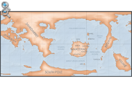
Gastrinimer's 3rd century BME Map of the World, showing Anásthias and the Natorn Isles. Note: old maps place north to the right.AnásthiasAnásthiasAnásthiasAnásthias
on the island continent of Anásthiasplugin-autotooltip__small plugin-autotooltip_bigAnásthias

Anásthias [a-NAS-thee-ass / ænæsθiːæs], or [an-ass-THEE-as] is an equatorial island continent, heart of the Civilised World. The north straddles the equator and is hot and humid, while most of the equatorial centre is an upland plateau with fertile river valleys, and stretches of arid plains and desert in the shadow of the mountains. The south is temperate but more wild, separated from the civilisations of the north by the almost impassable Harthera
, dominated by the two Great Powersplugin-autotooltip__small plugin-autotooltip_bigGreat Powers

Great Powers are the most powerful nations in the world, the greatest modern powers being Ororr and Harthera.
: the magicalplugin-autotooltip__small plugin-autotooltip_bigMagic

In common terms, magic is the art of producing a desired outcome through occult means. Various arts are described as magical, from common street illusionists, village herbalists, and rituals for the intercession of deities. However, true magic is the art and science of elemental mastery, harnessing elemental creatures and instructing them to perform simple or complex tasks.
theocracyplugin-autotooltip__small plugin-autotooltip_bigMother Church of Ororr (Therism)

The Mother Church is the state religion of Ororr, which combines both religion and government in one institution. It is based on the teachings of the Great Prophet Therion, who in the early decades of the modern era raised an army that conquered much of northwestern OrorrOrorrOrorrOrorrOrorrMEMEOrorrMEMEOrorrOrorrHerHerHerHerHerHerHerHerHerher
of Ororrplugin-autotooltip__small plugin-autotooltip_bigOrorr

Ororr [o-ROARR, ɒ̝rɔ'ɾ], also called the Holy Motherland of Ororr, is a theocratic nation in Anásthias, one of the world's great powers. It the largest nation in the world, perhaps the largest empire in history, occupying the entire northwest of the continent between the mountains and the sea. Ororrlanguagelanguagelanguage
, and the steam-powered naval might of Hartheraplugin-autotooltip__small plugin-autotooltip_bigHarthera

The Hartheran Union, commonly named Harthera, is an imperialist maritime nation state dominating the northeast of Anásthias. It is one of the two great powers of the modern epoch, arguably the most technologically and militarily powerful nation in the world, only matched by the vast size and wealth of its neighbour, viridOrorrMEOrorrOrorrOrorrOrorr
.

plugin-autotooltip__small plugin-autotooltip_bigVirid

Referring to the Virid Kingdom of flora and fauna, toxic to human life.


Random images

plugin-autotooltip__small plugin-autotooltip_bigAtlas: Narillin

[Zoom out?]

Narillin

Narillin [NAR-ill-EE-in] (Eloyoun Marille, historically Mariyë, also known as the Plaster City) is one of the great port cities of the world and the third largest city of Harthera.

It was an ancient Eloyoun city state, said to have been founded by refugees from EloyounHarthera

City of Narillîn

plugin-autotooltip__small plugin-autotooltip_bigAtlas: Anásthias (Poster version)

[Zoom out?]

Hover mouse/tap image to magnify

| Modern Political Map | Geography | Poster version | 1st Century History |

atlas

atlas

Continent of Anásthiasplugin-autotooltip__small plugin-autotooltip_bigAnásthias

Anásthias [a-NAS-thee-ass / ænæsθiːæs], or [an-ass-THEE-as] is an equatorial island continent, heart of the Civilised World. The north straddles the equator and is hot and humid, while most of the equatorial centre is an upland plateau with fertile river valleys, and stretches of arid plains and desert in the shadow of the mountains. The south is temperate but more wild, separated from the civilisations of the north by the almost impassable Harthera

plugin-autotooltip__small plugin-autotooltip_bigOrodien

Orodien [o-ROD-ee-en] was the mythical second realm of the Godmen, founded during the Jade Epoch after the destruction of the first realm of Yendim. The Orodien Peninsula in the north of the continent of Retzayk is named for the mythic realm, though whether this was the actual location, or even if the mythical Orodien existed, is uncertain.viridGodmen

Ancient Orodien

plugin-autotooltip__small plugin-autotooltip_bigAtlas: Anásthias (Poster version)

[Zoom out?]

Hover mouse/tap image to magnify

| Modern Political Map | Geography | Poster version | 1st Century History |

atlas

atlas

Continent of Anásthiasplugin-autotooltip__small plugin-autotooltip_bigAnásthias

Anásthias [a-NAS-thee-ass / ænæsθiːæs], or [an-ass-THEE-as] is an equatorial island continent, heart of the Civilised World. The north straddles the equator and is hot and humid, while most of the equatorial centre is an upland plateau with fertile river valleys, and stretches of arid plains and desert in the shadow of the mountains. The south is temperate but more wild, separated from the civilisations of the north by the almost impassable Harthera

Ridee

Ridee is an important city in the Sereouplugin-autotooltip__small plugin-autotooltip_bigSereou

Sereou is the drier, more temperate southern region of Otekahré.

Otekahré

Hover mouse to see more detail

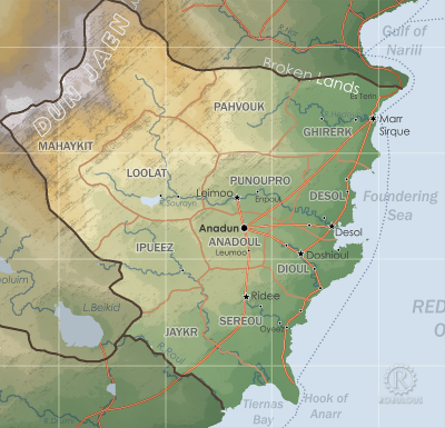
This is in a series of articles about the region of Otekahré in eastern Anásthias.

otekahre regions
region of Otekahreplugin-autotooltip__small plugin-autotooltip_bigOtekahré

Otekahré [oh-tek-AH-ray] (also called Anarthis in Harthera), is the southeastern region of Anásthias, lying south of Harthera and east of the Dun Jaen mountains. The region has no central governments, but the cities and polities are joined in a loose cultural and economic league, called HartheraOrorrviridHartheraOrorr
. Historically it is important as the home of the Bluefaceplugin-autotooltip__small plugin-autotooltip_bigUnfacing

Unfacing is a cultural practice and method of social control prevalent in Kahtoyn. Use of practices such as unfacing, blueface and gift economics distinguish Kahtoyn from the wider Otekahré region of eastern Anásthias.

Unfacing involves consciously ignoring, turning your back on, withholding communication and refusing help, as a form of social punishment. Unfacing begins in childhood as a punishment for children who are isolated for short periods, and extends to adulthood where serio…
philosophy which distinguishes modern Otekahre from its Eloyoun neighbours.

Otekahréplugin-autotooltip__small plugin-autotooltip_bigOtekahré (Category)

Articles related to Otekahré, the southeast region of the continent of Anásthias.

Otekahré

Hover mouse to see more detail

This is in a series of articles about the region of Otekahré in eastern Anásthias.

topics regi1

helevos:otekahre.png Hover mouse to see more detail

This is in a series of articles about the region of Otekahréplugin-autotooltip__small plugin-autotooltip_bigOtekahré

Otekahré [oh-tek-AH-ray] (also called Anarthis in Harthera), is the southeastern region of Anásthias, lying south of Harthera and east of the Dun Jaen mountains. The region has no central governments, but the cities and polities are joined in a loose cultural and economic league, called HartheraOrorrviridHartheraOrorr
in eastern Anásthiasplugin-autotooltip__small plugin-autotooltip_bigAnásthias

Anásthias [a-NAS-thee-ass / ænæsθiːæs], or [an-ass-THEE-as] is an equatorial island continent, heart of the Civilised World. The north straddles the equator and is hot and humid, while most of the equatorial centre is an upland plateau with fertile river valleys, and stretches of arid plains and desert in the shadow of the mountains. The south is temperate but more wild, separated from the civilisations of the north by the almost impassable Harthera
.

Imagory

Imagory is the one of the three main thaumaturgicalplugin-autotooltip__small plugin-autotooltip_bigThaumaturgy

Thaumaturgy Is a style of magic, codified and practiced by the Rasian Academy. Thaumaturgy and magic are terms often used interchangeably.

Magic

magic

This is in a series of articles about magic, thaumaturgy and esotericism.

Thaumaturgy means “work using thaumic energy”, also called Elemental Mastery, Elementalismmagicmagicmagiclanguagemagicmagicmagicmagicmagicmagicmagicmagic
disciplines, that of creating an imago: a convincingly realistic image of real-world or imaginary object or scene.

Magicplugin-autotooltip__small plugin-autotooltip_bigMagic

Magic, also called thaumaturgy is the art and science of harnessing elementals, and instructing them to carry out simple or complex tasks.

Invoking more powerful spirits or gods is a related but much more dangerous art, called theurgy.

Magic

magic

This is in a series of articles about

plugin-autotooltip__small plugin-autotooltip_bigMagic

Magic, also called thaumaturgy is the art and science of harnessing elementals, and instructing them to carry out simple or complex tasks.

Invoking more powerful spirits or gods is a related but much more dangerous art, called theurgy.

Magic

magic

This is in a series of articles about

This is in a series of articles about magic, thaumaturgy and esotericismplugin-autotooltip__small plugin-autotooltip_bigMagic

Magic, also called thaumaturgy is the art and science of harnessing elementals, and instructing them to carry out simple or complex tasks.

Invoking more powerful spirits or gods is a related but much more dangerous art, called theurgy.

Magic

magic

This is in a series of articles about
.

Despite its seeming simplicity, creating realistic and aesthetically pleasing imagos is one of the most difficult to master, as it requires not only a great skill, finesse and a high level of rapport between the magister and his primusplugin-autotooltip__small plugin-autotooltip_bigPrimus

A primus or prime source, vulgarly called a familiar or shadow, is an elemental is imprinted to a magister, being permanently bound with vinculum. The primus is the focal instrument and agent of his magical power. Primus is the official term used by magicians of the Rasian school of magic, though many other terms are used.
, but a degree of showmanship and artistic flair.

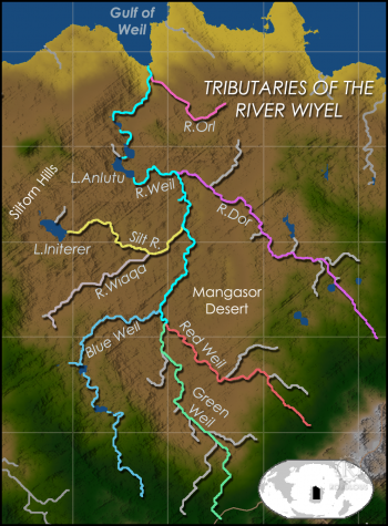
River Orl

The Orl is the last major tributary of the River Wiyelplugin-autotooltip__small plugin-autotooltip_bigRiver Wiyel

The River Wiyel or Weil [WILE, WAH-yil] in Ororr is the longest river in the Civilised World. The Wiyel Basin drains two thirds of modern Ororr, running over 5000 km from its source in the southern Dun Trisan mountains, flowing northwards to the sea.

Names

As the river is so long it has been known by many names by different civilisations throughout history. 'Wiel' is the name used during the time of the GreenOrorr
, joining it a mere 90km before it reaches the sea. The Orl flows from the eastern uplands in Gaskaninplugin-autotooltip__small plugin-autotooltip_bigGaskanin

Gaskanin is one of the six regions of Ororr, occupying the northeastern part of the country.

Ororr

This is in a series of articles on the modern nation-station of Ororr.

Hover to magnify | Go to world map

* Name: Holy Motherland of Ororr * Government: Theocratic Republic
to join the Great Wiyel, but has numerous cataracts making it not easily navigable. Since the founding of Ororrplugin-autotooltip__small plugin-autotooltip_bigOrorr

Ororr [o-ROARR, ɒ̝rɔ'ɾ], also called the Holy Motherland of Ororr, is a theocratic nation in Anásthias, one of the world's great powers. It the largest nation in the world, perhaps the largest empire in history, occupying the entire northwest of the continent between the mountains and the sea. Ororrlanguagelanguagelanguage
the construction of numerous locks have made the river the fastest route from the city of Galkeshplugin-autotooltip__small plugin-autotooltip_bigGalkesh

The modern city of Galkesh [GAL-kesh, g'alkeʃ] is capital of the Gaskanin region of northeastern Ororr, and of Galkesh province. In ancient times it was Gaalkedch [nGAHL-kedge-sh, ɣɑːːɫkeʒʃ], centre of the first Gaal Empire, and later the holy metropolis of the Empire of Dor-en-Sann.

Ororr

This is in a series of articles on the modern nation-station of OrorrME
to the sea.

Vigil of Deacon Kabe

The Vigil of Deacon Kabe is a mystery text significant to the animist traditional religion of Besoaplugin-autotooltip__small plugin-autotooltip_bigBesoa

Besoa [BEH-sso-AH], or Bizoa (Hartraan), is the largest island in the southern reach of the Natorn Archipelago. Today it is synonymous with the United Kingdom of Besoa.

Modern Besoa c.1100 ME | Go to world map

Besoa in the Two Nations period, 38-1092 ME

Besoa in the Four Kingdoms period, c.1200 BME - 35 ME BMEHartheraHartheranHartheranHartheranMEHartheraOrorrOrorr
. It is a first-person confession of a deacon or decan, one of the traditional ten intendants of the oracleplugin-autotooltip__small plugin-autotooltip_bigOracle

Oracles are sources of secret knowledge from the ancient world, believed to be the echoes of the Godmen of the first days.

There are a several examples of authentic surviving oracles:

* Welvér on Besoa * The Temple of the God-Mountain on Mount Karmoqué, Antyok * The Library of Orodien * Oracle of Rieve, on the isle of
shrine at Welvérplugin-autotooltip__small plugin-autotooltip_bigWelvér

Welvér [WELL-vair], also called the Well of Truth, is an oracle and religious site in the southeastern hills of Besoa, important to the traditional animist religion of the island.

Belief

This is in a series of articles about religions and beliefs.

The site has been used by successive civilisations for many thousands of years, and is littered with ruins and ancient artefacts. The oracle itself is an underground chamber accessed by a stone shaft, believed to have been constructed by …
, who mysteriously vanishes during an overnight vigil.

Belief

This is in a series of articles about religions and beliefsplugin-autotooltip__small plugin-autotooltip_bigBeliefs

A list of religions, beliefs and philosophies.

World religions

List of major religions in the modern Civilised World.

Deities

List of gods and deities, ancient and modern.

All beliefs

All other belief topics.

topics sidebar cult1
.

In the text, Kabe relates his personal history as a merchant, who treated his wife poorly and cheated his customers and suppliers. He left his bad life and became an acolyte and later deacon at Welvér, atoning for his past misdeeds by helping others. Framing this confessional are texts describing how Kabe would regularly spend whole nights in the oracle chamber, and how one morning the other deacons found him gone with only the text remaining.

The text is an important religious work in Besoa and a key inspiration for pilgrims and visitors to the oracle shrine.

Clickable Map

Clickable world mapplugin-autotooltip__small plugin-autotooltip_bigAtlas: Helevos interactive map

[fmap-hemispheres.png] * Zoom in * Zoom out * Planets * Moons * North Pole * South Pole * The Obverse * The Civilised World

Physical/Political map of Helevos. Click red flags to zoom in, or nav buttons to zoom out

< Historical world map

atlas

Helevos

Helevos (also known as Vos, or Veeos) is a temperate terrestrial world, fourth planet of the star Cordes in the viridgreenAnásthiasAnásthiasAnásthiasgreen

Candlenut

Candlenuts are the fruit of a viridplugin-autotooltip__small plugin-autotooltip_bigVirid

Referring to the Virid Kingdom of flora and fauna, toxic to human life.
shrub, whose oil is used for lighting, a variety of domestic and industrial uses, and refined for human consumption. Candlenut bushes are native to southern Otekahréplugin-autotooltip__small plugin-autotooltip_bigOtekahré

Otekahré [oh-tek-AH-ray] (also called Anarthis in Harthera), is the southeastern region of Anásthias, lying south of Harthera and east of the Dun Jaen mountains. The region has no central governments, but the cities and polities are joined in a loose cultural and economic league, called HartheraOrorrviridHartheraOrorr
, Munatanplugin-autotooltip__small plugin-autotooltip_bigMunatan

Munatan [Moo-Nah-Tahn] is the southernmost region of Anásthias, south of the Dun Trisan mountains. The name possibly derives from a ancient Thalsic, meaning “Land of One Sun”, since the daystar is not visible in the southern hemisphere. Or it may be a reference to the Manthi people who were once the majority population of western Munatan. The term is an OrorrOrorrOrorrHartheraHartheraOrorrOrorrOrorrHartheraHartheraHartheran
and the virid jungles of southwestern Ororrplugin-autotooltip__small plugin-autotooltip_bigOrorr

Ororr [o-ROARR, ɒ̝rɔ'ɾ], also called the Holy Motherland of Ororr, is a theocratic nation in Anásthias, one of the world's great powers. It the largest nation in the world, perhaps the largest empire in history, occupying the entire northwest of the continent between the mountains and the sea. Ororrlanguagelanguagelanguage
, where they form part of the staple diet.

Floraplugin-autotooltip__small plugin-autotooltip_bigFlora

Topics related to herbs, crops and plantlife.

Subcategories

Articles

All

Green Flora

Virid Flora

topics sci1

plugin-autotooltip__small plugin-autotooltip_bigHerbs

A list of green plants used in herblore for their culinary, medicinal, psychotropic or physical properties.

Herbs

herbs

This is in a series of articles about Herbs and Herblore.

topics flora1

This is in a series of articles about Plants and Floraplugin-autotooltip__small plugin-autotooltip_bigFlora

Topics related to herbs, crops and plantlife.

Subcategories

Articles

All

Green Flora

Virid Flora

topics sci1
.

→ Read more...plugin-autotooltip__small plugin-autotooltip_bigCandlenut

Candlenuts are the fruit of a virid shrub, whose oil is used for lighting, a variety of domestic and industrial uses, and refined for human consumption. Candlenut bushes are native to southern Otekahré, Munatan and the virid jungles of southwestern Ororr, where they form part of the staple diet.viridvirid

Trenya

Trenya is a peninsula in southwestern Trésardplugin-autotooltip__small plugin-autotooltip_bigTrésard

Common name for the Kingdom of Trésard.
, often synonymous with the adminstrative distict of Trenyard. plugin-autotooltip__small plugin-autotooltip_bigAtlas: Kingdom of Trésard

[fmap-tresard.png] * Zoom out

* Rasia * Larford * Episcin * Laharkin Mountains * Golobath * Beyan * Muthene Marsh * Por Muel * Muul * Rana * Waysmeet

atlas nationmaps

Kingdom of Trésard

The Hexactic Kingdom of Trésard [tray-SSARD] is a nation in the Anrel Isles, occupying the northern half of the Mainland and the island of Mûul. The kingdom was forged in 238

Trenya has a mild climate and fertile loamy soils making it one of the most productive and wealthy regions of the Anrel Islesplugin-autotooltip__small plugin-autotooltip_bigAnrel Isles

Alternate name for Anrel.
. The Margraveplugin-autotooltip__small plugin-autotooltip_bigAnrel Aristocracy

The Anrel Isles are governed by a class collectively called the Grafen or Graves, individually given the courtesy title Graf. Leaders of towns, cities, and even nations are drawn from this class. Traditionally, leaders are selected by will of the populace, based on their personal qualities and family merits, according to the traditional honour system of Anrel
of Trenya is traditionally one of the most powerful in the kingdom.

→ Read more...plugin-autotooltip__small plugin-autotooltip_bigTrenya

Trenya is a peninsula in southwestern Trésard, often synonymous with the adminstrative distict of Trenyard. tresard

Trenya has a mild climate and fertile loamy soils making it one of the most productive and wealthy regions of the Anrel Isles. The Margrave of Trenya is traditionally one of the most powerful in the kingdom.

Broken Lands

The Broken Lands is a fractured region of sharp fissures, clefts and gullies, which forms a natural boundary between Hartheraplugin-autotooltip__small plugin-autotooltip_bigHarthera

The Hartheran Union, commonly named Harthera, is an imperialist maritime nation state dominating the northeast of Anásthias. It is one of the two great powers of the modern epoch, arguably the most technologically and militarily powerful nation in the world, only matched by the vast size and wealth of its neighbour, viridOrorrMEOrorrOrorrOrorrOrorr
and Otekahréplugin-autotooltip__small plugin-autotooltip_bigOtekahré

Otekahré [oh-tek-AH-ray] (also called Anarthis in Harthera), is the southeastern region of Anásthias, lying south of Harthera and east of the Dun Jaen mountains. The region has no central governments, but the cities and polities are joined in a loose cultural and economic league, called HartheraOrorrviridHartheraOrorr
.

Otekahréplugin-autotooltip__small plugin-autotooltip_bigOtekahré (Category)

Articles related to Otekahré, the southeast region of the continent of Anásthias.

Otekahré

Hover mouse to see more detail

This is in a series of articles about the region of Otekahré in eastern Anásthias.

topics regi1

helevos:otekahre.png Hover mouse to see more detail

This is in a series of articles about the region of Otekahréplugin-autotooltip__small plugin-autotooltip_bigOtekahré

Otekahré [oh-tek-AH-ray] (also called Anarthis in Harthera), is the southeastern region of Anásthias, lying south of Harthera and east of the Dun Jaen mountains. The region has no central governments, but the cities and polities are joined in a loose cultural and economic league, called HartheraOrorrviridHartheraOrorr
in eastern Anásthiasplugin-autotooltip__small plugin-autotooltip_bigAnásthias

Anásthias [a-NAS-thee-ass / ænæsθiːæs], or [an-ass-THEE-as] is an equatorial island continent, heart of the Civilised World. The north straddles the equator and is hot and humid, while most of the equatorial centre is an upland plateau with fertile river valleys, and stretches of arid plains and desert in the shadow of the mountains. The south is temperate but more wild, separated from the civilisations of the north by the almost impassable Harthera
.

The region is an active fault line, where earthquakes have created sharp rifts in the rock, further excavated and eroded by winds and flash flooding. With little soil and little surface water, the Broken Lands are uninhabitable and hazardous to travellers, since the canyons run erratically east-west in a confusion of narrow gulleys and dead ends, making it impassable for vehicles and a tortuous maze for travellers. Consequently almost all trade between the regions goes by sea, or along the narrow coastal path.

In the past the Broken Lands have protected Otekahré from invasion by its northern neighbour, with several Hartheranplugin-autotooltip__small plugin-autotooltip_bigHarthera

The Hartheran Union, commonly named Harthera, is an imperialist maritime nation state dominating the northeast of Anásthias. It is one of the two great powers of the modern epoch, arguably the most technologically and militarily powerful nation in the world, only matched by the vast size and wealth of its neighbour, viridOrorrMEOrorrOrorrOrorrOrorr
expeditions attempting to invade Marr Sirqueplugin-autotooltip__small plugin-autotooltip_bigMarr Sirque

Marr Sirque [mar SEE-urkh] (Miyarrain: Miyarsouok; Hartheran: Narsik) is a port city in Kahtoyn, the principle trading port in Otekahré.

Otekahré

Hover mouse to see more detail

This is in a series of articles about the region of Otekahré in eastern Anásthias.

Historically it was an outlying river city of Hartheran
by land being lost in its treacherous labyrinth.

New & Updated

Today's date


Pages & images

1112 articles 390 maps & images


Recent updates

All contents © 2024 Robert How, robulous.com

 
start.txt · Last modified: 2023/05/31 10:04 by Robert How · []