Welcome to Helevos

plugin-autotooltip__small plugin-autotooltip_bigAtlas: Helevos interactive map

[fmap-hemispheres.png] * Zoom in * Zoom out * Planets * Moons * North Pole * South Pole * The Obverse * The Civilised World

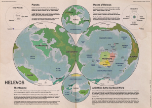
Physical/Political map of Helevos. Click red flags to zoom in, or nav buttons to zoom out

< Historical world map

atlas

Helevos

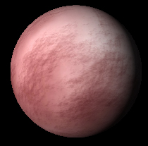
Helevos (also known as Vos, or Veeos) is a temperate terrestrial world, fourth planet of the star Cordes in the viridgreenAnásthiasAnásthiasAnásthiasgreen

- Click for interactive world map

Helevosplugin-autotooltip__small plugin-autotooltip_bigHelevos

Helevos (also known as Vos, or Veeos) is a temperate terrestrial world, fourth planet of the star Cordes in the Cronox binary star system. The stars Cordes and Arjos are distant binaries, so on Helevos, Arjos is only seen in the northern hemisphere as star, sometimes bright enough to be seen during the day, circling roughly over the viridgreenAnásthiasAnásthiasAnásthiasgreen
is a fantasy world of magicplugin-autotooltip__small plugin-autotooltip_bigMagic

In common terms, magic is the art of producing a desired outcome through occult means. Various arts are described as magical, from common street illusionists, village herbalists, and rituals for the intercession of deities. However, true magic is the art and science of elemental mastery, harnessing elemental creatures and instructing them to perform simple or complex tasks.
and science, divided by two incompatible biologies: the Green Kingdomplugin-autotooltip__small plugin-autotooltip_bigGreen

The Green Kingdom of flora and fauna includes humans, mammals, birds, whales, greenfish, and most green plants and crops cultivated by humankind.
of humans, trees, grasses, cropsplugin-autotooltip__small plugin-autotooltip_bigFlora

Topics related to herbs, crops and plantlife.

Subcategories

Articles

All

Green Flora

Virid Flora

topics sci1
and red-blooded animalsplugin-autotooltip__small plugin-autotooltip_bigMammals

List of red-blooded mammals, members of the Green Kingdom closely related to humans.

Fauna

This is in a series of articles about Animals.

topics faun1
, and the Virid Kingdomplugin-autotooltip__small plugin-autotooltip_bigVirid

Referring to the Virid Kingdom of flora and fauna, toxic to human life.
of toxic jungles, poisonous plants, terrifying creatures and airborne infectionsplugin-autotooltip__small plugin-autotooltip_bigSpor

Spor are the single-celled reproductive units of virid plants, distinct from seeds or spores found in the green kingdom. Most spor are airborne, release from spor-pods, the fruiting bodies of virid plants. Many spor are motile with rudimentary flagella, either fertilising mature plants, or randomly bonding with the spor of other plants and settling to make a new plant seedling.viridviridvirid
.

Over thousands of years humans have forged the hundred nationsplugin-autotooltip__small plugin-autotooltip_bigModern Nations

The Civilised World has many nations, from small island republics to vast continental empires, which over the millennia have carved homelands out of the once hostile virid landscape. The two great opposing world powers of today are the holy nation of Ororr and the maritime empire of
of the Civilised Worldplugin-autotooltip__small plugin-autotooltip_bigCivilised World

The Civilised World refers to the known regions of human civilisation, notably the continent of Anásthias, the Natorn Archipelago and surrounding islands.

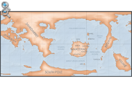
Gastrinimer's 3rd century BME Map of the World, showing Anásthias and the Natorn Isles. Note: old maps place north to the right.AnásthiasAnásthiasAnásthiasAnásthias
on the island continent of Anásthiasplugin-autotooltip__small plugin-autotooltip_bigAnásthias

Anásthias [a-NAS-thee-ass / ænæsθiːæs], or [an-ass-THEE-as] is an equatorial island continent, heart of the Civilised World. The north straddles the equator and is hot and humid, while most of the equatorial centre is an upland plateau with fertile river valleys, and stretches of arid plains and desert in the shadow of the mountains. The south is temperate but more wild, separated from the civilisations of the north by the almost impassable Harthera
, dominated by the two Great Powersplugin-autotooltip__small plugin-autotooltip_bigGreat Powers

Great Powers are the most powerful nations in the world, the greatest modern powers being Ororr and Harthera.
: the magicalplugin-autotooltip__small plugin-autotooltip_bigMagic

In common terms, magic is the art of producing a desired outcome through occult means. Various arts are described as magical, from common street illusionists, village herbalists, and rituals for the intercession of deities. However, true magic is the art and science of elemental mastery, harnessing elemental creatures and instructing them to perform simple or complex tasks.
theocracyplugin-autotooltip__small plugin-autotooltip_bigMother Church of Ororr (Therism)

The Mother Church is the state religion of Ororr, which combines both religion and government in one institution. It is based on the teachings of the Great Prophet Therion, who in the early decades of the modern era raised an army that conquered much of northwestern OrorrOrorrOrorrOrorrOrorrMEMEOrorrMEMEOrorrOrorrHerHerHerHerHerHerHerHerHerher
of Ororrplugin-autotooltip__small plugin-autotooltip_bigOrorr

Ororr [o-ROARR, ɒ̝rɔ'ɾ], also called the Holy Motherland of Ororr, is a theocratic nation in Anásthias, one of the world's great powers. It the largest nation in the world, perhaps the largest empire in history, occupying the entire northwest of the continent between the mountains and the sea. Ororrlanguagelanguagelanguage
, and the steam-powered naval might of Hartheraplugin-autotooltip__small plugin-autotooltip_bigHarthera

The Hartheran Union, commonly named Harthera, is an imperialist maritime nation state dominating the northeast of Anásthias. It is one of the two great powers of the modern epoch, arguably the most technologically and militarily powerful nation in the world, only matched by the vast size and wealth of its neighbour, viridOrorrMEOrorrOrorrOrorrOrorr
.

plugin-autotooltip__small plugin-autotooltip_bigVirid

Referring to the Virid Kingdom of flora and fauna, toxic to human life.


Random images

plugin-autotooltip__small plugin-autotooltip_bigAtlas: Besoa

[fmap-besoa.png] * Zoom in * Zoom out

* Antyok * @ * @ * @ * @ * @ * @ * @ * @ * @

atlas nationmaps

Besoa

Besoa [BEH-sso-AH], or Bizoa (Hartraan), is the largest island in the southern reach of the Natorn Archipelago. Today it is synonymous with the United Kingdom of Besoa.

Modern Besoa c.1100 ME | Go to world map

Besoa in the Two Nations period, 38-1092 MEMEBMEHartheraHartheranHartheranHartheranMEHartheraOrorrOrorr

United Kingdom of Besóa

plugin-autotooltip__small plugin-autotooltip_bigAtlas: Gastrinimer's World Map

[Zoom out?]

atlas citymaps

Aego Gastrinimer

Aego Gastrinimer (c. 311-254 BME), was a renowned navigator, explorer, merchantman, privateer and prestigious Cartographer-Royal to the Court of Sann'al. He produced the first great world map of the modern era, based on his supposed circumnavigation of the continent of AnásthiasAnásthiasAnásthiasAnásthias

Ancient Anásthiasplugin-autotooltip__small plugin-autotooltip_bigAnásthias

Anásthias [a-NAS-thee-ass / ænæsθiːæs], or [an-ass-THEE-as] is an equatorial island continent, heart of the Civilised World. The north straddles the equator and is hot and humid, while most of the equatorial centre is an upland plateau with fertile river valleys, and stretches of arid plains and desert in the shadow of the mountains. The south is temperate but more wild, separated from the civilisations of the north by the almost impassable Harthera
parchment

plugin-autotooltip__small plugin-autotooltip_bigAtlas: Ancient Anásthias in the 1st Century ME

[Zoom out?]

| Modern Political Map | Geography | Poster version | 1st Century History |

atlas

Anásthias

Anásthias [a-NAS-thee-ass / ænæsθiːæs], or [an-ass-THEE-as] is an equatorial island continent, heart of the Civilised World. The north straddles the equator and is hot and humid, while most of the equatorial centre is an upland plateau with fertile river valleys, and stretches of arid plains and desert in the shadow of the mountains. Th…

Ancient history of Anásthiasplugin-autotooltip__small plugin-autotooltip_bigAnásthias

Anásthias [a-NAS-thee-ass / ænæsθiːæs], or [an-ass-THEE-as] is an equatorial island continent, heart of the Civilised World. The north straddles the equator and is hot and humid, while most of the equatorial centre is an upland plateau with fertile river valleys, and stretches of arid plains and desert in the shadow of the mountains. The south is temperate but more wild, separated from the civilisations of the north by the almost impassable Harthera

plugin-autotooltip__small plugin-autotooltip_bigOrodien

Orodien [o-ROD-ee-en] was the mythical second realm of the Godmen, founded during the Jade Epoch after the destruction of the first realm of Yendim. The Orodien Peninsula in the north of the continent of Retzayk is named for the mythic realm, though whether this was the actual location, or even if the mythical Orodien existed, is uncertain.viridGodmen

Ancient Orodien

Boat-cloak

A boat-cloak is a large garment of skin or waxed fabric, which wraps around the wearer to protect them from harsh weather. The outer edges of the cloak have a series of inflatable pockets, so that when the cloak is laid flat and inflated, it forms a small boat or raft.

Clothingplugin-autotooltip__small plugin-autotooltip_bigClothing

Textiles, armour, uniforms and other items of clothing.

cult1 topics

This is in a series of articles on Clothing and textilesplugin-autotooltip__small plugin-autotooltip_bigClothing

Textiles, armour, uniforms and other items of clothing.

cult1 topics
.

The boat-cloak is accompanied by a pack containing additional equipment: a hand-bellows used for inflation and as a pump for bailing water, and a number of rods and panels which give the boat a floor and a more rigid shape. Wearers also carry a walking stick with a small collapsible sail, which can be attached to the boat as a mast.

Boat-cloaks were particularly used by the historic Jundaplugin-autotooltip__small plugin-autotooltip_bigJunda People

The Junda are an Iskean-ethnic people found throughout the Junda Isles and the northeast coast of Anásthias, whose conquest of the mainland led to the foundation of the modern state of Harthera.

Historically they were notable for their shamanic religion and unique calendar, the Junda stormscale.

Junda peoples commonly raided the coasts for food and goods, having little of worth to trade on their home islands. They were accidentally instrumental in the downfall of the
and Asokwayplugin-autotooltip__small plugin-autotooltip_bigAsokway People

The Asokway are an Iskean-ethnic people living in the Natorn Archipelago and islands off the coast of Harthera. They are believed to be descendants of a breakaway or even proto-Iskean group who preferred to remain in the smaller islands of the archipelago rather than joining with the great civilisation of
peoples in the islands of the Natorn Seaplugin-autotooltip__small plugin-autotooltip_bigNatorn Sea

The Natorn Sea is a region of oceanic ridge, separating the Polassirn Ocean and the Redeeming Ocean. Islands in the ridge form the Natorn Archipelago.

Etymology

The name may be derived from ancient Ahngrit, meaning “near/of our birth”, referring to the legend of the Godmen in which humanity is said to have originated in region now lost beneath the sea. It also relates to the god
, to travel back and forth between the many small islands without having to carry a boat.

Eidolons of Seqal

The Eidolons of the Goddess, commonly called the Eidolons of Seqal, are a triptych of ancient statues carved into the rocky riverside at the city of Seqalplugin-autotooltip__small plugin-autotooltip_bigSeqal

Seqal is a historic city in Ororr, at the confluence of two tributaries of the River Wiyel. The ancient city was cut into the rock between the two rivers, making it one of the “Hidden Cities” that were mainly underground. Today the majority of the population live in New Seqal, built on the river bank a little downriver from the Old City.Ororr
in Ororrplugin-autotooltip__small plugin-autotooltip_bigOrorr

Ororr [o-ROARR, ɒ̝rɔ'ɾ], also called the Holy Motherland of Ororr, is a theocratic nation in Anásthias, one of the world's great powers. It the largest nation in the world, perhaps the largest empire in history, occupying the entire northwest of the continent between the mountains and the sea. Ororrlanguagelanguagelanguage
. The figures are a renowned symbol of the city, being the first thing seen by visitors travelling upriver to the city.

Belief

This is in a series of articles about religions and beliefsplugin-autotooltip__small plugin-autotooltip_bigBeliefs

Belief

This is in a series of articles about religions and beliefs.

A list of religions, beliefs and philosophies.

World religions

List of major religions in the modern Civilised World.

Deities

List of gods and deities, ancient and modern.

All beliefs

All other belief topics.
.

The Eidolons are colossal caryatids, columns over 18 metres high, supporting the portico of the ancient Temple overlooking the river. The portico and its sculptures were carved into the living rock face, so that the portico roof protects the carvings from weathering. The temple was once a simple cave, consecrated to the worship of the river goddess some time in the Beryl Epochplugin-autotooltip__small plugin-autotooltip_bigBeryl Epoch

Historic epoch, age of the Empire of Dor-en-Sann.
. It was later expanded and embellished as the city of Seqal grew more powerful as an economic and religious centre.

The first Eidolons were carved around 2500 BMEplugin-autotooltip__small plugin-autotooltip_bigBME (Before Modern Epoch)

Used to date years Before the Modern Epoch.
. Originally they depicted fertility goddesses as large, naked Issid women, which were crudely shaped and probably painted in bright colours. They were later resculpted and refaced several times into more slender and graceful forms, ending in their current shape around 1400 BMEplugin-autotooltip__small plugin-autotooltip_bigBME (Before Modern Epoch)

Used to date years Before the Modern Epoch.
.

The resculpted eidolons were dressed with a mosaic of jade and precious jewels, so that they glinted in the sun and presented a powerful symbol of the wealth and importance of Seqal as a city-state. Originally the the were decorated with a combination of true jade, white jade and greenplugin-autotooltip__small plugin-autotooltip_bigGreen

The Green Kingdom of flora and fauna includes humans, mammals, birds, whales, greenfish, and most green plants and crops cultivated by humankind.
quartz. Later right-hand eidolon was blue jade representing water, green jade representing life, fertility and the greenplugin-autotooltip__small plugin-autotooltip_bigGreen

The Green Kingdom of flora and fauna includes humans, mammals, birds, whales, greenfish, and most green plants and crops cultivated by humankind.
world. The left-hand was red jade, representing blood, death and retribution. The rare red jade was mined from the valley of the Red Wiyelplugin-autotooltip__small plugin-autotooltip_bigRiver Wiyel

The River Wiyel or Weil [WILE, WAH-yil] in Ororr is the longest river in the Civilised World. The Wiyel Basin drains two thirds of modern Ororr, running over 5000 km from its source in the southern Dun Trisan mountains, flowing northwards to the sea.

Names

As the river is so long it has been known by many names by different civilisations throughout history. 'Wiel' is the name used during the time of the GreenOrorr
, upriver of Seqal, a particularly valuable export of the city. Together, the three jade eidolons were a dazzling display of the city-state's wealth, trading reach and moral power. It is often thought the the branches of the Well, were named after the colour of the Eidolons, rather than vice versa.

After the decline of Seqal and its domination by the Empire of Dor-en-Sannplugin-autotooltip__small plugin-autotooltip_bigEmpire of Dor-en-Sann

The Empire of Dor-en-Sann, [DOORR-enn-SAHN] also called the EnSanni Empire, was the largest empire in history. It dominated central Anásthias for nearly two thousand years, from 1903 BME, until the conquest of Galkesh in 59 ME. The empire consisted of hundreds of ethnic groups and cultures, its people were collectively called the MEOrorrHMOrorrHMHartheraME
, the temple fell into disrepair and the jade mosaics were either looted or fell away. By the time the city was visited by the Great Prophetplugin-autotooltip__small plugin-autotooltip_bigGreat Prophet

The Great Prophet Therion, founder of the Mother Church of Ororr.
it was a shadow of its former grandeur, but the Prophet was so impressed by the vista of the Seqal that, despite the destruction of hundreds of grand Imperial temples to the north, he ordered the Eidolons be spared.

As such, the Temple at Seqal is one of the chief stopping points on the Shouftplugin-autotooltip__small plugin-autotooltip_bigShouft

The Shouft, also called the Path of the Prophet or the Great Pilgrimage, is a religious journey to the holy shrine of Foratuna in Ororr. It is a key element of Therist religious practice, a spiritual journey visiting sites of religious significance.

The devout wishing spiritual enrichment, or sinners or criminals wishing to make restitution, follow the route the Ororrgreengreen
or great pilgrimage, and one of the Protected Treasuresplugin-autotooltip__small plugin-autotooltip_bigProtected Treasures

In Ororr, the Protected Treasures are a number of historic monuments, artefacts and religious sites which have been preserved under a special protective status, despite their pagan or prehistoric origins.

Ororr

This is in a series of articles on the modern nation-station of Ororr
of the church-state.

Today the rock of the Eidolons is topped with a Theristplugin-autotooltip__small plugin-autotooltip_bigMother Church of Ororr (Therism)

The Mother Church is the state religion of Ororr, which combines both religion and government in one institution. It is based on the teachings of the Great Prophet Therion, who in the early decades of the modern era raised an army that conquered much of northwestern OrorrOrorrOrorrOrorrOrorrMEMEOrorrMEMEOrorrOrorrHerHerHerHerHerHerHerHerHerher
padata of modern construction, called the Jade Flower Templeplugin-autotooltip__small plugin-autotooltip_bigJade Flower Temple

The Jade Flower Temple is a Therist pandata at the city of Seqal in Ororr. It sits on the rocky promontory above the famous Eidolons of Seqal, a landmark well known to travellers and pilgrims along the River Wiyel. At night it is lit with brasiers so its green glow is visible from a great distance.greenTherist
. The cave-temple of the Eidolons was once closed and used for storage, but is now a museum of ancient history.

Veilspor

Veilspor is a type of viridplugin-autotooltip__small plugin-autotooltip_bigVirid

Referring to the Virid Kingdom of flora and fauna, toxic to human life.
decompositional mould which covers dead and dying organisms in a cobweb-like veil. It is often seen in virid forests surrounding fallen trees, dead branches and sickly vegetation. It is sometimes found in poorly maintained human dwellings, particularly in basements and dark abandoned rooms. If left untreated it slowly engulfs whole buildings.

Floraplugin-autotooltip__small plugin-autotooltip_bigFlora

Topics related to herbs, crops and plantlife.

Subcategories

Articles

All

Green Flora

Virid Flora

topics sci1

plugin-autotooltip__small plugin-autotooltip_bigHerbs

A list of green plants used in herblore for their culinary, medicinal, psychotropic or physical properties.

Herbs

herbs

This is in a series of articles about Herbs and Herblore.

topics flora1

This is in a series of articles about Plants and Floraplugin-autotooltip__small plugin-autotooltip_bigFlora

Topics related to herbs, crops and plantlife.

Subcategories

Articles

All

Green Flora

Virid Flora

topics sci1
.

Veilspor produces tendrils coated with dusty virid spores which can drift on the air with slightest touch. Veilspor spores can infect the mucus membranes of living virid animals, including wights and other jinniesplugin-autotooltip__small plugin-autotooltip_bigJinnies

Vulgar term for the indigenous natives of Helevos.
, particularly those who are sick or elderly. Some strains can infect humans, attaching to soft tissues in the nose and mouth. These outbreaks are usually self-limiting and found only in humans with weakened immunity due to disease and famine.

Veilspor was a pernicious threat in the war-ravaged Anrel Islesplugin-autotooltip__small plugin-autotooltip_bigAnrel Isles

Alternate name for Anrel.
during the Orphans Warplugin-autotooltip__small plugin-autotooltip_bigOrphans War

Alternative name for the Long War.

redirects
, where ruined towns and villages were overcome with spor, and starving children were so afflicted from the spor it was said to grow from them instead of hair. Consequently it is known in folkloreplugin-autotooltip__small plugin-autotooltip_bigFolklore

Folklore

This is in a series of articles about oral traditions, tales, folk practices, and folklore.

topics cult1
as the “grey terror” or the “white death”, and sometimes associated with the The Namelessplugin-autotooltip__small plugin-autotooltip_bigThe Nameless

The Nameless, or the Nameless One, is a supernatural being in the Anrelian Pantheon the personification of chaos and destruction, in opposition to the forces of nature.

The Nameless is therefore opposite to The One, who represents both creation and the natural cycle of birth, life and death. The Nameless is considered to be a malign and corrupting force that sows chaos and breaks the natural cycles of the world. He is therefore associated with war, destruction, plague, famine and …
.

Vetthi naming conventions

Vetthi names are a fiendishly complicated social hurdle for all visitors to the island, and can represent a challenge even to the most socially adept Vetthi hierarch. Vetthi names can be lengthy, since they describe not only family connections, but a history of honours and distinctions both personal and inherited. The longer a person's name, the greater the prestige of the family, and those wishing to curry favour are obliged to remember the entire name of a new associate.

→ Read more...plugin-autotooltip__small plugin-autotooltip_bigVetthi naming conventions

Vetthi names are a fiendishly complicated social hurdle for all visitors to the island, and can represent a challenge even to the most socially adept Vetthi hierarch. Vetthi names can be lengthy, since they describe not only family connections, but a history of honours and distinctions both personal and inherited. The longer a person's name, the greater the prestige of the family, and those wishing to curry favour are obliged to remember the entire name of a new associ…

Clickable Map

Clickable world mapplugin-autotooltip__small plugin-autotooltip_bigAtlas: Helevos interactive map

[fmap-hemispheres.png] * Zoom in * Zoom out * Planets * Moons * North Pole * South Pole * The Obverse * The Civilised World

Physical/Political map of Helevos. Click red flags to zoom in, or nav buttons to zoom out

< Historical world map

atlas

Helevos

Helevos (also known as Vos, or Veeos) is a temperate terrestrial world, fourth planet of the star Cordes in the viridgreenAnásthiasAnásthiasAnásthiasgreen

Enpoul

Enpoul is a city on the River Souraynplugin-autotooltip__small plugin-autotooltip_bigRiver Sourayn

The Sourayn is the great river of central Kahtoyn in eastern Anásthias. It connects the cities of Leimoo, Enpoul with the sea port of Desol, irrigating the richest farmlands in Kahtoyn along the way.

Otekahré

Hover mouse to see more detail

This is in a series of articles about the region of
in Kahtoynplugin-autotooltip__small plugin-autotooltip_bigKahtoyn

Kahtoyn (called Bhourdan in Hartraan), also called the Confederation of Kahtoyn, is a political entity in the region of Otekahré. It is unique in the world that it is not a nation in the true sense, since it has no formal governmental structures, no kings or governors, no military or police, no codified laws, prisons or justice system. Instead it is made up of thousands of self-governing polities who follow a common ideology of good behaviour, common standards, and (mostly) friendly com…
.

Otekahréplugin-autotooltip__small plugin-autotooltip_bigOtekahré (Category)

Articles related to Otekahré, the southeast region of the continent of Anásthias.

topics regi1

helevos:otekahre.png Hover mouse to see more detail

This is in a series of articles about the region of Otekahréplugin-autotooltip__small plugin-autotooltip_bigOtekahré

Otekahré [oh-tek-AH-ray] (also called Anarthis in Harthera), is the southeastern region of Anásthias, lying south of Harthera and east of the Dun Jaen mountains. The region has no central governments, but the cities and polities are joined in a loose cultural and economic league, called HartheraOrorrviridHartheraOrorr
in eastern Anásthiasplugin-autotooltip__small plugin-autotooltip_bigAnásthias

Anásthias [a-NAS-thee-ass / ænæsθiːæs], or [an-ass-THEE-as] is an equatorial island continent, heart of the Civilised World. The north straddles the equator and is hot and humid, while most of the equatorial centre is an upland plateau with fertile river valleys, and stretches of arid plains and desert in the shadow of the mountains. The south is temperate but more wild, separated from the civilisations of the north by the almost impassable Harthera
.

Torthien Crisis

The Torthien Crisis (1018-1026 MEplugin-autotooltip__small plugin-autotooltip_bigME

ME is short for Modern Epoch, the modern method of numbering years.
) was an international conflict which brought the world closest to total war than at any time in history. It began as a proxy war between the great powersplugin-autotooltip__small plugin-autotooltip_bigGreat Powers

Great Powers are the most powerful nations in the world, the greatest modern powers being Ororr and Harthera.
of Ororrplugin-autotooltip__small plugin-autotooltip_bigOrorr

Ororr [o-ROARR, ɒ̝rɔ'ɾ], also called the Holy Motherland of Ororr, is a theocratic nation in Anásthias, one of the world's great powers. It the largest nation in the world, perhaps the largest empire in history, occupying the entire northwest of the continent between the mountains and the sea. Ororrlanguagelanguagelanguage
and Hartheraplugin-autotooltip__small plugin-autotooltip_bigHarthera

The Hartheran Union, commonly named Harthera, is an imperialist maritime nation state dominating the northeast of Anásthias. It is one of the two great powers of the modern epoch, arguably the most technologically and militarily powerful nation in the world, only matched by the vast size and wealth of its neighbour, viridOrorrMEOrorrOrorrOrorrOrorr
, who funded and encouraged rebel groups as well as smaller nations to fight on their behalf. The crisis focussed on the mountainous region of Torthienplugin-autotooltip__small plugin-autotooltip_bigTorthien

Torthien is a common but now outdated term for the region of Taur-Dji-Oum, particularly used in Harthera.
, or Taur-Dji-Oumplugin-autotooltip__small plugin-autotooltip_bigTaur-Dji-Oum

Taur-Dji-Oum [Tower-shjee-ohm], known as Torthien in much of the Civilised World, also called the Vale of Tortanis in Ororr, is an upland area of southeastern Anásthias. It is a politically complex and unstable region, consisting of twenty-three major ethnic nations, territorially sub-divided into smaller kingdoms, chiefdoms, fiefdoms and clan holdings, with a shifting pattern of allegiances and alliances.
.

Conflict

This is in a series of articles on Wars, Battles and Conflictsplugin-autotooltip__small plugin-autotooltip_bigConflicts

List of military conflicts, including wars, battles and military campaigns.

Conflict

This is in a series of articles on Wars, Battles and Conflicts.

topics hist1
.

The crisis culminated in the Torthien Treaty (1026 MEplugin-autotooltip__small plugin-autotooltip_bigModern Epoch (ME)

The Modern Calendar is a dating system acknowledged throughout the Civilised World. It numbers years from the Modern Epoch, abbreviated ME and BME (Before Modern Epoch). It is also called the Modern Era.

Calendar

This is in a series of articles about calendars and dating systems.OrorrHartheraHMOrorrHartheraOrorrOrorrHMHartheraHMHartheraOrorr
), which clearly defined national and regional boundaries and established formal embassies and lines of communication. Most importantly it agreed that Hartheraplugin-autotooltip__small plugin-autotooltip_bigHarthera

The Hartheran Union, commonly named Harthera, is an imperialist maritime nation state dominating the northeast of Anásthias. It is one of the two great powers of the modern epoch, arguably the most technologically and militarily powerful nation in the world, only matched by the vast size and wealth of its neighbour, viridOrorrMEOrorrOrorrOrorrOrorr
would not expand further south into Otekahréplugin-autotooltip__small plugin-autotooltip_bigOtekahré

Otekahré [oh-tek-AH-ray] (also called Anarthis in Harthera), is the southeastern region of Anásthias, lying south of Harthera and east of the Dun Jaen mountains. The region has no central governments, but the cities and polities are joined in a loose cultural and economic league, called HartheraOrorrviridHartheraOrorr
, and Ororrplugin-autotooltip__small plugin-autotooltip_bigOrorr

Ororr [o-ROARR, ɒ̝rɔ'ɾ], also called the Holy Motherland of Ororr, is a theocratic nation in Anásthias, one of the world's great powers. It the largest nation in the world, perhaps the largest empire in history, occupying the entire northwest of the continent between the mountains and the sea. Ororrlanguagelanguagelanguage
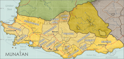
would not attempt to control, or religiously convert, Torthien. The treaty stabilised the borders between the two powers, but thereby shifted the modern war of influence further south into Munatanplugin-autotooltip__small plugin-autotooltip_bigMunatan

Munatan [Moo-Nah-Tahn] is the southernmost region of Anásthias, south of the Dun Trisan mountains. The name possibly derives from a ancient Thalsic, meaning “Land of One Sun”, since the daystar is not visible in the southern hemisphere. Or it may be a reference to the Manthi people who were once the majority population of western Munatan. The term is an OrorrOrorrOrorrHartheraHartheraOrorrOrorrOrorrHartheraHartheraHartheran
.

→ Read more...plugin-autotooltip__small plugin-autotooltip_bigTorthien Crisis

The Torthien Crisis (1018-1026 ME) was an international conflict which brought the world closest to total war than at any time in history. It began as a proxy war between the great powers of Ororr and Harthera, who funded and encouraged rebel groups as well as smaller nations to fight on their behalf. The crisis focussed on the mountainous region of HartheraOrorrOrorrHarthera

Tsaykoui

Tsaykoui is a large island group on the eastern edge on the Redeeming Oceanplugin-autotooltip__small plugin-autotooltip_bigRedeeming Ocean

The Redeeming Ocean, historically known by it's Miyarrain name, the Poomué, separates the Civilised World from the eastern continent of Retzayk. It is 4500km across at its narrowest point. It has a number of small islands, the Eastern Isles being the only sizeable group.
, 5600 km southeast of the Hook of Anarrplugin-autotooltip__small plugin-autotooltip_bigHook of Anarr

The Hook of Anarr, also called the Horn of Sere, is an isolated and sparsely inhabited peninsula in the southeast of Kahtoyn in Otekahré. Its marks the division between the Redeeming Ocean and the Great Urash Ocean.

Otekahré

Hover mouse to see more detail

This is in a series of articles about the region of
and 1600 km south of the southernmost tip of Retzaykplugin-autotooltip__small plugin-autotooltip_bigRetzayk

Retzayk is a long, narrow continent approximately 4500 km east of Anásthias, separated from it by the Redeeming Ocean. It extends from the North Pole, crossing the equator and deep into the southern hemisphere.

retzayk

Eastern continent of Retzayk

According to contemporary geography, Retzayk is believed to be one of the Anásthiasviridviridvirid
. Their latitude extends from 33-43°S, the climate ranging from sub-tropical to temperate. plugin-autotooltip__small plugin-autotooltip_bigAtlas: Tsaykoui

[atlas-tsaykoui.png] * Zoom in * Zoom out

* @ * @ * @ * @ * @ * @ * @ * @ * @ * @

Tsaykoui

Tsaykoui is a large island group on the eastern edge on the Redeeming Ocean, 5600 km southeast of the Hook of Anarr and 1600 km south of the southernmost tip of Retzayk. Their latitude extends from 33-43°S, the climate ranging from sub-tropical to temperate.

The landscape is mostly low elevation, and due to their isolation they are all covered in a unique variety of viridplugin-autotooltip__small plugin-autotooltip_bigVirid

Referring to the Virid Kingdom of flora and fauna, toxic to human life.
vegetation, mostly low-lying shrubs and lush broad-leafed jungle. Animal diversity is low, and there are no large viridplugin-autotooltip__small plugin-autotooltip_bigVirid

Referring to the Virid Kingdom of flora and fauna, toxic to human life.
animals.

The islands were documented and named by the ancient Miyarrainplugin-autotooltip__small plugin-autotooltip_bigMiyarrain People

The Miyarrain were the inhabitants of ancient Miyarris, famed as the most advanced civilisation of the Celadon Epoch. The Miyarrain were the progenitors of all modern Eloyoun peoples throughout eastern Anásthias.

Ancient Miyarris

This is in a series of articles about the ancient civilisation of
, but they are unknown to the modern Civilised Worldplugin-autotooltip__small plugin-autotooltip_bigCivilised World

The Civilised World refers to the known regions of human civilisation, notably the continent of Anásthias, the Natorn Archipelago and surrounding islands.

Gastrinimer's 3rd century BME Map of the World, showing Anásthias and the Natorn Isles. Note: old maps place north to the right.AnásthiasAnásthiasAnásthiasAnásthias
.

New & Updated

Today's date


Pages & images

1112 articles 390 maps & images


Recent updates

All contents © 2024 Robert How, robulous.com

 
start.txt · Last modified: 2023/05/31 14:04 by Robert How · []