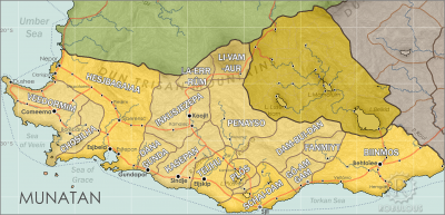
Chosilha
Chosilha [cho-SEAL-ya] is a territory in western Munatan, where the civil war war that tore apart the old Ennseperan Empire continues to grind on, long after the empire fell. The territory is controlled by warlords, inheritors of the old imperial Loyalist and Republican factions, Republican warlords holding the north, Imperials in the south.
Munatanplugin-autotooltip__small plugin-autotooltip_bigMunatan (Category)
Articles about Munatan, the far southern region of Anásthias.
Nations
Cities
topics regi1
 Hover mouse to see more detail | Go to full atlas mapplugin-autotooltip__small plugin-autotooltip_bigAtlas: Munatan
[munatan.png] * Zoom out * East Munatan * West Munatan
Munatan
Munatan [Moo-Nah-Tahn] is the southernmost region of Anásthias, south of the Dun Trisan mountains. The name possibly derives from a ancient OrorrOrorrOrorrHartheraHartheraOrorrOrorrOrorrHartheraHartheraHartheran
This is in a series of articles about Munatanplugin-autotooltip__small plugin-autotooltip_bigMunatan
Munatan [Moo-Nah-Tahn] is the southernmost region of Anásthias, south of the Dun Trisan mountains. The name possibly derives from a ancient Thalsic, meaning “Land of One Sun”, since the daystar is not visible in the southern hemisphere. Or it may be a reference to the Manthi people who were once the majority population of western Munatan. The term is an OrorrOrorrOrorrHartheraHartheraOrorrOrorrOrorrHartheraHartheraHartheran, the temperate region of southern Anásthiasplugin-autotooltip__small plugin-autotooltip_bigAnásthias
Anásthias [a-NAS-thee-ass / ænæsθiːæs], or [an-ass-THEE-as] is an equatorial island continent, heart of the Civilised World. The north straddles the equator and is hot and humid, while most of the equatorial centre is an upland plateau with fertile river valleys, and stretches of arid plains and desert in the shadow of the mountains. The south is temperate but more wild, separated from the civilisations of the north by the almost impassable Harthera.
Name
Chosilha means “the island” in Hespor, referring to its geographical isolation within the old Empire. At the end of the War of Schisms the diehard Imperialists were forced into the far southwest of the old empire, with various Republicanist factions fighting a bitter guerilla war against both them, and the newly founded monarchy of Hesjbagaaia. Fighting was effectively confined to this region, called pejoratively, “Chosilha”.
Today the Imperialist faction claim the entire territory as the Empire of Jhohor, after the late great pretender to the imperial throne. The Republicans call it the Irredental Republic, though there are still many warring and competing Republican factions. Both sides claim to represent the whole region, though both only hold fragmentary territory.
Consequently most of the world knows the region as Chosilha.
History
Until the 2nd century ME, Chosilha was an underpopulated province of Veedormim. As Veedormim came under gradual dominance of the Ennseperan Empire, Chosilha was annexed as a buffer state protecting the rich new territories around the Limerent Sea. In this period some of the virid hillside jungle was cut back, creating low grade farmland.
Towards the end of the War of Schisms in 700 ME, Chosilha became the retreat of the Emperor and his remaining forces. When the official armistice was agreed in 701, the southern coastal region was held by the Eijult Empire, and both Imperialist and Hesjbagaaian forces concentrated on expelling the Manthi threat. Republican forces, always a minor force during the War of Schisms, seized the north of Chosilha and attempted to renew the war against the Hesjbagaaian Kingdom, gaining significant control of territory in the north. Once the Eijult were expelled, Imperialist forces attempted to turn and expel the Republicans, but were exhausted of men and supplies. Guerilla warfare has continued for hundreds of years, with neither side gaining the upper hand.
Today Chosilha remains a poor rump state which is nominally independent, but de facto under the domination of Hesjbagaaia, forming a buffer zone of contested territory.
