Welcome to Helevos

plugin-autotooltip__small plugin-autotooltip_bigAtlas: Helevos interactive map

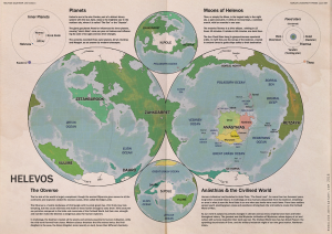
[fmap-hemispheres.png] * Zoom in * Zoom out * Planets * Moons * North Pole * South Pole * The Obverse * The Civilised World

Physical/Political map of Helevos. Click red flags to zoom in, or nav buttons to zoom out

< Historical world map

atlas

Helevos

Helevos (also known as Vos, or Veeos) is a temperate terrestrial world, fourth planet of the star Cordes in the viridgreenAnásthiasAnásthiasAnásthiasgreen

- Click for interactive world map

Helevosplugin-autotooltip__small plugin-autotooltip_bigHelevos

Helevos (also known as Vos, or Veeos) is a temperate terrestrial world, fourth planet of the star Cordes in the Cronox binary star system. The stars Cordes and Arjos are distant binaries, so on Helevos, Arjos is only seen in the northern hemisphere as star, sometimes bright enough to be seen during the day, circling roughly over the viridgreenAnásthiasAnásthiasAnásthiasgreen
is a fantasy world of magicplugin-autotooltip__small plugin-autotooltip_bigMagic

In common terms, magic is the art of producing a desired outcome through occult means. Various arts are described as magical, from common street illusionists, village herbalists, and rituals for the intercession of deities. However, true magic is the art and science of elemental mastery, harnessing elemental creatures and instructing them to perform simple or complex tasks.
and science, divided by two incompatible biologies: the Green Kingdomplugin-autotooltip__small plugin-autotooltip_bigGreen

The Green Kingdom of flora and fauna includes humans, mammals, birds, whales, greenfish, and most green plants and crops cultivated by humankind.
of humans, trees, grasses, cropsplugin-autotooltip__small plugin-autotooltip_bigFlora

Topics related to herbs, crops and plantlife.

Subcategories

Articles

All

Green Flora

Virid Flora

topics sci1
and red-blooded animalsplugin-autotooltip__small plugin-autotooltip_bigMammals

List of red-blooded mammals, members of the Green Kingdom closely related to humans.

Fauna

This is in a series of articles about Animals.

topics faun1
, and the Virid Kingdomplugin-autotooltip__small plugin-autotooltip_bigVirid

Referring to the Virid Kingdom of flora and fauna, toxic to human life.
of toxic jungles, poisonous plants, terrifying creatures and airborne infectionsplugin-autotooltip__small plugin-autotooltip_bigSpor

Spor are the single-celled reproductive units of virid plants, distinct from seeds or spores found in the green kingdom. Most spor are airborne, release from spor-pods, the fruiting bodies of virid plants. Many spor are motile with rudimentary flagella, either fertilising mature plants, or randomly bonding with the spor of other plants and settling to make a new plant seedling.viridviridvirid
.

Over thousands of years humans have forged the hundred nationsplugin-autotooltip__small plugin-autotooltip_bigModern Nations

The Civilised World has many nations, from small island republics to vast continental empires, which over the millennia have carved homelands out of the once hostile virid landscape. The two great opposing world powers of today are the holy nation of Ororr and the maritime empire of
of the Civilised Worldplugin-autotooltip__small plugin-autotooltip_bigCivilised World

The Civilised World refers to the known regions of human civilisation, notably the continent of Anásthias, the Natorn Archipelago and surrounding islands.

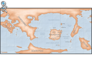
Gastrinimer's 3rd century BME Map of the World, showing Anásthias and the Natorn Isles. Note: old maps place north to the right.AnásthiasAnásthiasAnásthiasAnásthias
on the island continent of Anásthiasplugin-autotooltip__small plugin-autotooltip_bigAnásthias

Anásthias [a-NAS-thee-ass / ænæsθiːæs], or [an-ass-THEE-as] is an equatorial island continent, heart of the Civilised World. The north straddles the equator and is hot and humid, while most of the equatorial centre is an upland plateau with fertile river valleys, and stretches of arid plains and desert in the shadow of the mountains. The south is temperate but more wild, separated from the civilisations of the north by the almost impassable Harthera
, dominated by the two Great Powersplugin-autotooltip__small plugin-autotooltip_bigGreat Powers

Great Powers are the most powerful nations in the world, the greatest modern powers being Ororr and Harthera.
: the magicalplugin-autotooltip__small plugin-autotooltip_bigMagic

In common terms, magic is the art of producing a desired outcome through occult means. Various arts are described as magical, from common street illusionists, village herbalists, and rituals for the intercession of deities. However, true magic is the art and science of elemental mastery, harnessing elemental creatures and instructing them to perform simple or complex tasks.
theocracyplugin-autotooltip__small plugin-autotooltip_bigMother Church of Ororr (Therism)

The Mother Church is the state religion of Ororr, which combines both religion and government in one institution. It is based on the teachings of the Great Prophet Therion, who in the early decades of the modern era raised an army that conquered much of northwestern OrorrOrorrOrorrOrorrOrorrMEMEOrorrMEMEOrorrOrorrHerHerHerHerHerHerHerHerHerher
of Ororrplugin-autotooltip__small plugin-autotooltip_bigOrorr

Ororr [o-ROARR, ɒ̝rɔ'ɾ], also called the Holy Motherland of Ororr, is a theocratic nation in Anásthias, one of the world's great powers. It the largest nation in the world, perhaps the largest empire in history, occupying the entire northwest of the continent between the mountains and the sea. Ororrlanguagelanguagelanguage
, and the steam-powered naval might of Hartheraplugin-autotooltip__small plugin-autotooltip_bigHarthera

The Hartheran Union, commonly named Harthera, is an imperialist maritime nation state dominating the northeast of Anásthias. It is one of the two great powers of the modern epoch, arguably the most technologically and militarily powerful nation in the world, only matched by the vast size and wealth of its neighbour, viridOrorrMEOrorrOrorrOrorrOrorr
.

plugin-autotooltip__small plugin-autotooltip_bigVirid

Referring to the Virid Kingdom of flora and fauna, toxic to human life.


Random images

plugin-autotooltip__small plugin-autotooltip_bigEijult Empire

The Eijult Empire dominated much of the coastal territory of western Munatan during the 6th and 7th centuries ME. It was forged by the Manthi-ethnic Eijult people, who spread along the coast by land and by sea, seizing control and settling lands once held by the

Historic Eijult Empire

plugin-autotooltip__small plugin-autotooltip_bigBesoa

Besoa [BEH-sso-AH], or Bizoa (Hartraan), is the largest island in the southern reach of the Natorn Archipelago. Today it is synonymous with the United Kingdom of Besoa.

Modern Besoa c.1100 ME | Go to world map

Besoa in the Two Nations period, 38-1092 ME

Besoa in the Four Kingdoms period, c.1200 BME - 35 ME BMEHartheraHartheranHartheranHartheranMEHartheraOrorrOrorr

Four Kingdoms of Besóa

plugin-autotooltip__small plugin-autotooltip_bigNomez

Nomez [NOM-ez] is a heavy, dense planet orbiting closest to the sun Cordes, in the Cronox System.

Its surface is molten and constantly active, almost half of its surface being a sea of liquid sulphur and mineral salts. It has a toxic atmosphere of gaseous chlorine, bromine, sulphur, and phosphorus belched from the ever-active volcanoes, with clouds of light metals like lead and arsenic. This atmosphere is constantly eroded away by solar wind, leaving a glowing, flare-like trail in …

Planet Nomez

plugin-autotooltip__small plugin-autotooltip_bigBesoa

Besoa [BEH-sso-AH], or Bizoa (Hartraan), is the largest island in the southern reach of the Natorn Archipelago. Today it is synonymous with the United Kingdom of Besoa.

Modern Besoa c.1100 ME | Go to world map

Besoa in the Two Nations period, 38-1092 ME

Besoa in the Four Kingdoms period, c.1200 BME - 35 ME BMEHartheraHartheranHartheranHartheranMEHartheraOrorrOrorr

Four Kingdoms of Besóa

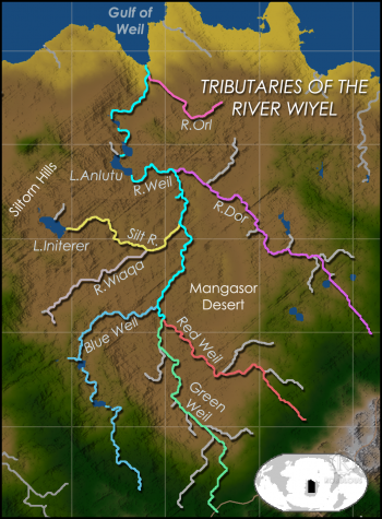
River Orl

The Orl is the last major tributary of the River Wiyelplugin-autotooltip__small plugin-autotooltip_bigRiver Wiyel

The River Wiyel or Weil [WILE, WAH-yil] in Ororr is the longest river in the Civilised World. The Wiyel Basin drains two thirds of modern Ororr, running over 5000 km from its source in the southern Dun Trisan mountains, flowing northwards to the sea.

Names

As the river is so long it has been known by many names by different civilisations throughout history. 'Wiel' is the name used during the time of the GreenOrorr
, joining it a mere 90km before it reaches the sea. The Orl flows from the eastern uplands in Gaskaninplugin-autotooltip__small plugin-autotooltip_bigGaskanin

Gaskanin is one of the six regions of Ororr, occupying the northeastern part of the country.

Ororr

This is in a series of articles on the modern nation-station of Ororr.

Hover to magnify | Go to world map

* Name: Holy Motherland of Ororr * Government: Theocratic Republic
to join the Great Wiyel, but has numerous cataracts making it not easily navigable. Since the founding of Ororrplugin-autotooltip__small plugin-autotooltip_bigOrorr

Ororr [o-ROARR, ɒ̝rɔ'ɾ], also called the Holy Motherland of Ororr, is a theocratic nation in Anásthias, one of the world's great powers. It the largest nation in the world, perhaps the largest empire in history, occupying the entire northwest of the continent between the mountains and the sea. Ororrlanguagelanguagelanguage
the construction of numerous locks have made the river the fastest route from the city of Galkeshplugin-autotooltip__small plugin-autotooltip_bigGalkesh

The modern city of Galkesh [GAL-kesh, g'alkeʃ] is capital of the Gaskanin region of northeastern Ororr, and of Galkesh province. In ancient times it was Gaalkedch [nGAHL-kedge-sh, ɣɑːːɫkeʒʃ], centre of the first Gaal Empire, and later the holy metropolis of the Empire of Dor-en-Sann.

Ororr

This is in a series of articles on the modern nation-station of OrorrME
to the sea.

Commensalism

Commensalism (also called Commensarism, from Hesporplugin-autotooltip__small plugin-autotooltip_bigHespor

Hespor is the common language of Hesjbagaaia, an Essep language with considerable influences from Doroun as well as native languages of Munatan.

Language

language

This is in a series of articles about Languages and Communication.

Due to the power of Hesjbagaaia and the historical influence of the Ennseperan Empire, Hespor is the dominant trade and diplomatic languageMunatan
Cormensjara) is a political philosophy which proposes appropriating existing social and power structures to create a pluralist political and economic system which is beneficial to all. It derives from cor, meaning group, and mensja, meaning platter - literally, all eating from the same table.

Governanceplugin-autotooltip__small plugin-autotooltip_bigGovernance

Articles on governance and politics.

Culture

This is a category of articles on Arts, Music, Literature & Culture.

topics cult1

This is in a series of articles on goverments and politicsplugin-autotooltip__small plugin-autotooltip_bigGovernance

Articles on governance and politics.

Culture

This is a category of articles on Arts, Music, Literature & Culture.

topics cult1
.

Commensalism was first proposed in Ennseperansplugin-autotooltip__small plugin-autotooltip_bigEnnseperans

Alternate name for the Ennseperan Empire.
in the decade leading up to the War of Schismsplugin-autotooltip__small plugin-autotooltip_bigWar of Schisms

The War of Schisms (683-701 ME) was a wide-ranging religious, ethnic and civil war which shattered the former Empire of Ennseperans.

Conflict

This is in a series of articles on Wars, Battles and Conflicts.

At the time, the King-Emperor and an aristocratic class of mainly Dorouns ruled over a multi-ethnic populace consisting of
. It was one of the key ideological movements in the war, and remains a key ideology in much of the politics of Munatanplugin-autotooltip__small plugin-autotooltip_bigMunatan

Munatan [Moo-Nah-Tahn] is the southernmost region of Anásthias, south of the Dun Trisan mountains. The name possibly derives from a ancient Thalsic, meaning “Land of One Sun”, since the daystar is not visible in the southern hemisphere. Or it may be a reference to the Manthi people who were once the majority population of western Munatan. The term is an OrorrOrorrOrorrHartheraHartheraOrorrOrorrOrorrHartheraHartheraHartheran
.

As a philosophy it proposes examining traditional political structures, throwing out the power and privilege that goes along with those roles, and restructuring whilst retaining the confidence that goes with a traditional system. An example of this would be a society which has a king and court who maintain their position by wealth and privilege, and replacing this with a meritocracy, and a king appointed by majority of the people. Key elements of Commensalism include collective decision making with the views of all respected, and a redistributive tax policy.

Following the War of Schismsplugin-autotooltip__small plugin-autotooltip_bigWar of Schisms

The War of Schisms (683-701 ME) was a wide-ranging religious, ethnic and civil war which shattered the former Empire of Ennseperans.

Conflict

This is in a series of articles on Wars, Battles and Conflicts.

At the time, the King-Emperor and an aristocratic class of mainly Dorouns ruled over a multi-ethnic populace consisting of
and the dissolution of the Ennseperan Empireplugin-autotooltip__small plugin-autotooltip_bigEnnseperan Empire

The Holy Empire of EnSann and Essep, commonly called the Ennseperan Empire or simply Ennseperans, was a historic state in the southwest of Anásthias, existing from 101-683 ME.

Ennseperans

[ ]

This is in a series of articles about the Ennseperan Empire.

It encompassed the modern nation of OrorrOrorrOrorrOrorrOrorr
, many of its successor states in western Munatanplugin-autotooltip__small plugin-autotooltip_bigMunatan

Munatan [Moo-Nah-Tahn] is the southernmost region of Anásthias, south of the Dun Trisan mountains. The name possibly derives from a ancient Thalsic, meaning “Land of One Sun”, since the daystar is not visible in the southern hemisphere. Or it may be a reference to the Manthi people who were once the majority population of western Munatan. The term is an OrorrOrorrOrorrHartheraHartheraOrorrOrorrOrorrHartheraHartheraHartheran
used Commensalist principles to a greater or lesser extent in constituting new nations. Penaysoplugin-autotooltip__small plugin-autotooltip_bigPenayso

Penayso, also known as Penaysepa, is a confederation of tribal states in Munatan. Its capital is the city of Fromchis.

Munatan

Hover mouse to see more detail | Go to full atlas map

This is in a series of articles about Munatan, the temperate region of southern Anásthias.

History

Penayso was formed in 852
was the most radical of these, using Commensalist principles to create a national assembly in a nation subjected to colonialism and suffering tribal and ethnic violence.

Hidden Cities

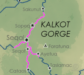
The Hidden Cities is a historic term for the part-subterranean cities of the Kalkot Gorgeplugin-autotooltip__small plugin-autotooltip_bigKalkot Gorge

The Kalkot Gorge is a reach of the River Wiyel in Sekalkot province in central Ororr. Over millions of year the river has carved a deep channel into the surrounding karst rock, creating a high-sided gorge stretching hundreds of kilometres through an otherwise arid landscape.
, particularly Seqalplugin-autotooltip__small plugin-autotooltip_bigSeqal

Seqal is a historic city in Ororr, at the confluence of two tributaries of the River Wiyel. The ancient city was cut into the rock between the two rivers, making it one of the “Hidden Cities” that were mainly underground. Today the majority of the population live in New Seqal, built on the river bank a little downriver from the Old City.Ororr
, Sopeqplugin-autotooltip__small plugin-autotooltip_bigSopeq

Sopeq is a prosperous city on the River Wiyel in Ororr, about 100 km north of Seqal. Sopeq was founded as one of the northernmost colonies of the Kingdom of Seqal, but has long eclipsed its ancient progenitor. Though Sopeq is much larger, for historic reasons Seqal remains the official capital of the province. In the Ororr
and Sequbplugin-autotooltip__small plugin-autotooltip_bigSequb

Sequb is a town in the Kalkot Gorge region of central Ororr. It is one of the traditional Hidden Cities of Kalkot, since many dwellings are cut into the steep walls of the gorge.

It was a prosperous city in antiquity but inability to expand has made it little more than a sleepy backwater today, an overnight stopping point for pilgrim boats on the
.

The cities were originally built in caves and hollows in the karst rock of the steep-sided river valley, so they were entirely hidden from sight to travellers journeying across the plains above. In modern times the gorge is much more cluttered and the cities far larger, mainly built on the plains above with only the docks areas being next to the river.

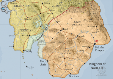
River Minnd

The River Minnd [MINN-d] (also Minde [MIN-duh]) is the principle river of Naretteplugin-autotooltip__small plugin-autotooltip_bigKingdom of Narette

The Kingdom of Narette, or Naret [na-RET, na rɛt] (arch. Anret or Anrette), is a modern nation occupying the southern half of the largest island in the Anrel Isles. Before the Orphans War it was called the Kingdom of Anrette.

Narette

narette

This is in a series of articles about the AnrelAnrelAnrelAnrelAnrelAnrel
in the Anrel Islesplugin-autotooltip__small plugin-autotooltip_bigAnrel Isles

Alternate name for Anrel.
. Due to the unique geography of the Ania Plateauplugin-autotooltip__small plugin-autotooltip_bigAnia Plateau

The Ania Plateau [AH-nee-uh, 'ɑːniə] is an upland plateau in the southwest of Narette, in the Anrel Isles. The land is fertile and well-drained, home to the majority of Narette's population and agriculture.

The easiest route up to the Plateau is via Binid in the south, where the escarpment is much lower, and a succession of low slopes make vehicle traffic much easier to traverse.
, it flows from its source northwards over the Minnd Falls to the plains, where it curves southeastward to the sea at Belisanplugin-autotooltip__small plugin-autotooltip_bigBelisan Freeport

The city of Belisan [beh-li-SAN], known internationally as Belisan Freeport, is a port city surrounding Belisan Bay, at the mouth of the River Minnd in southeast Anret.

Belisan is actually two cities divided by the river. Belisan City lies on the west of the river, with its Royal Docks subject to normal customs tariffs. East of the river is the
. The river valley forms the agricultural heartland of Narette.

Naretteplugin-autotooltip__small plugin-autotooltip_bigNarette (Category)

Articles related to the Kingdom of Narette in the Anrel Isles.

All topics

Cities

anrel nati1 topics

plugin-autotooltip__small plugin-autotooltip_bigAtlas: Kingdom of Narette

[fmap-narette.png] * Zoom in * Zoom out

* @ * @ * @ * @ * @ * @ * @ * @ * @ * @

atlas nationmaps

Kingdom of Narette

The Kingdom of Narette, or Naret [na-RET, na rɛt] (arch. Anret or Anrette), is a modern nation occupying the southern half of the largest island in the AnrelAnrelAnrelAnrelAnrelAnrel

This is in a series of articles about the Kingdom of Naretteplugin-autotooltip__small.

  • Name: Kingdom of Narette
  • Demonym: Naretian [na-REE-shun]
  • Government: Hexactic Monarchyplugin-autotooltip__small plugin-autotooltip_bigHexact Doctrine

    The Hexact Doctrine is a philosophy of government developed in Anrel in the early 3rd century ME, with the aim of creating governments that benefited the health, wealth and wellbeing of its citizens. It is the model for many governments throughout the MEAnrelAnrelAnrelAnrelAnrelAnrelAnrel
  • Capital: Heth Aniaplugin-autotooltip__small plugin-autotooltip_bigHeth Ania

    Heth Ania [HETH AH-nee-uh] is the royal capital of the Kingdom of Narette. It is a modern and cosmopolitan city, centre for sea trade between Narette and Trésard.

    History

    Settlements have existed in the area throughout recorded history, but the first city was built as a colony of the Annéans in the second millenium ME
  • Currency: Hexactic Almplugin-autotooltip__small plugin-autotooltip_bigHexactic Alm

    The Hexactic Alm [ARM] is the official currency of the nations of Anrel, accepted throughout the Natorn Archipelago. An alm is worth six pins, and 24 alms are a crown.

    Money

    [ ]

    This is in a series of articles about money, currencies and finance.

    The alm originally a food token given to refugees during the Anrel
    , Naretian Crown
  • Foundation: 215 MEplugin-autotooltip__small plugin-autotooltip_bigModern Epoch (ME)

    The Modern Calendar is a dating system acknowledged throughout the Civilised World. It numbers years from the Modern Epoch, abbreviated ME and BME (Before Modern Epoch). It is also called the Modern Era.

    Calendar

    This is in a series of articles about calendars and dating systems.OrorrHartheraHMOrorrHartheraOrorrOrorrHMHartheraHMHartheraOrorr
  • Language: Rettienplugin-autotooltip__small plugin-autotooltip_bigRettien

    Rettien is an Aralsic language spoken in Narette in the Anrel Isles. Although it shares much common vocabulary with Reidan, Rettien is heavily influenced by Old Oracilem, the Iskean language of the former city-state of Oracil.

    Language

    language

    This is in a series of articles about Languages and Communication.

    Rettien has two distinct dialects. High Rettien is the languagelanguagelanguagelanguage

There is some evidence the Minnd originally flowed in the opposite direction towards the sea, but the gradual tilting of the Ania Plate resulted in water flowing northward instead of south.

Clickable Map

Clickable world mapplugin-autotooltip__small plugin-autotooltip_bigAtlas: Helevos interactive map

[fmap-hemispheres.png] * Zoom in * Zoom out * Planets * Moons * North Pole * South Pole * The Obverse * The Civilised World

Physical/Political map of Helevos. Click red flags to zoom in, or nav buttons to zoom out

< Historical world map

atlas

Helevos

Helevos (also known as Vos, or Veeos) is a temperate terrestrial world, fourth planet of the star Cordes in the viridgreenAnásthiasAnásthiasAnásthiasgreen

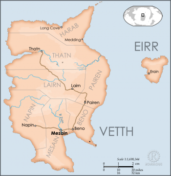
Mezain

Mezain is the capital city of the Vetthi Republicplugin-autotooltip__small plugin-autotooltip_bigVetthi Republic

The Vetthi Republic is a prosperous island nation which plays a crucial role in trade and international affairs. Its position in the Vetthi Sea north of Ororr makes it a strategic trade hub between Anrel, Harthera and Ororr.

* Name: The Vetthi Republic * Government:OrorrHartheraOrorrOrorrviridviridOrorrOrorrOrorrTheristepochsvirid
, one of the key merchant ports in international trade. It is the home port of the wealthy Vetthi Merchant Fleetplugin-autotooltip__small plugin-autotooltip_bigVetthi Merchant Fleet

The Vetthi Merchant Fleet of the Vetthi Merchant Company is the most prestigious merchant navy in the world, with trade concessions and trading rights in virtually every port throughout the Civilised World. Its influence, wealth and prestige is the pride of the
, as well as centre of the Vetthi government.

→ Read more...plugin-autotooltip__small plugin-autotooltip_bigMezain

Mezain is the capital city of the Vetthi Republic, one of the key merchant ports in international trade. It is the home port of the wealthy Vetthi Merchant Fleet, as well as centre of the Vetthi government.

Name

Mezain means “mouth of the river Zuin”.

Geography

The city is situated on a slightly elevated plateau on the banks of the River Zuin, high enough to be protected from flooding. It lies approximately 6 km from the open sea. The Zuin estuary is unusually deep and navigable eve…

Lake Plós

Lake Plós is a large, kidney-shaped body of fresh water in Munatanplugin-autotooltip__small plugin-autotooltip_bigMunatan

Munatan [Moo-Nah-Tahn] is the southernmost region of Anásthias, south of the Dun Trisan mountains. The name possibly derives from a ancient Thalsic, meaning “Land of One Sun”, since the daystar is not visible in the southern hemisphere. Or it may be a reference to the Manthi people who were once the majority population of western Munatan. The term is an OrorrOrorrOrorrHartheraHartheraOrorrOrorrOrorrHartheraHartheraHartheran
, which gives its name to the nation of Plósplugin-autotooltip__small plugin-autotooltip_bigPlós

Plós [pl-OH-s, pl'əʊ̯s] is a nation in central Munatan, centred around Lake Plós. It is bordered by Inkusjezepa and Schai-dam.

Munatan

Hover mouse to see more detail | Go to full atlas map

This is in a series of articles about Munatan, the temperate region of southern Anásthias.

In the Beryl Epoch Plós was an ancient philosopher-oligarchy which once exercised great influence on the region, both culturally and politically, despite never having great military strength. Instead its lea…
. It is 150 km at its longest axis, northwest to southeast.

Munatanplugin-autotooltip__small plugin-autotooltip_bigMunatan (Category)

Articles about Munatan, the far southern region of Anásthias.

Nations

Cities

topics regi1

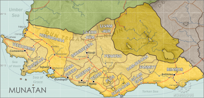
helevos:munatan.png Hover mouse to see more detail | Go to full atlas mapplugin-autotooltip__small plugin-autotooltip_bigAtlas: Munatan

[munatan.png] * Zoom out * East Munatan * West Munatan
Munatan

Munatan [Moo-Nah-Tahn] is the southernmost region of Anásthias, south of the Dun Trisan mountains. The name possibly derives from a ancient OrorrOrorrOrorrHartheraHartheraOrorrOrorrOrorrHartheraHartheraHartheran

This is in a series of articles about Munatanplugin-autotooltip__small plugin-autotooltip_bigMunatan

Munatan [Moo-Nah-Tahn] is the southernmost region of Anásthias, south of the Dun Trisan mountains. The name possibly derives from a ancient Thalsic, meaning “Land of One Sun”, since the daystar is not visible in the southern hemisphere. Or it may be a reference to the Manthi people who were once the majority population of western Munatan. The term is an OrorrOrorrOrorrHartheraHartheraOrorrOrorrOrorrHartheraHartheraHartheran
, the temperate region of southern Anásthiasplugin-autotooltip__small plugin-autotooltip_bigAnásthias

Anásthias [a-NAS-thee-ass / ænæsθiːæs], or [an-ass-THEE-as] is an equatorial island continent, heart of the Civilised World. The north straddles the equator and is hot and humid, while most of the equatorial centre is an upland plateau with fertile river valleys, and stretches of arid plains and desert in the shadow of the mountains. The south is temperate but more wild, separated from the civilisations of the north by the almost impassable Harthera
.

The lake is important for the local economy and climate, being well stocked with greenfishplugin-autotooltip__small plugin-autotooltip_bigGreenfish

Term including all red-blooded fish edible to humans and other mammals.
which is an important regional food source.

Plós means “The Water” in the local Manthiplugin-autotooltip__small plugin-autotooltip_bigManthi People

The Manthi are a diverse group of Jorothi-ethnic peoples found in southwestern Anásthias, particularly southwestern Ororr, Veedormim and the Manthi-Lien.

Ethnicity

ethnicity

This is in a series of articles about anthropology, ethnicity and race.

History

The early Manthi migrated south along the coast of Anásthias from the Jorothi homelands in what is now northwestern viridvirid
-derived tongue.

River Garn

The River Garn is a river in eastern Ororr, flowing from the hills and mountains of eastern Ororr into the Wiyel and thence to the sea. Though in a strict geographic sense the Garn is a tributary of the River Wiyelplugin-autotooltip__small plugin-autotooltip_bigRiver Wiyel

The River Wiyel or Weil [WILE, WAH-yil] in Ororr is the longest river in the Civilised World. The Wiyel Basin drains two thirds of modern Ororr, running over 5000 km from its source in the southern Dun Trisan mountains, flowing northwards to the sea.

Names

As the river is so long it has been known by many names by different civilisations throughout history. 'Wiel' is the name used during the time of the GreenOrorr
, by convention the Garn flows into the much shorter River Dorplugin-autotooltip__small plugin-autotooltip_bigRiver Dor

The River Dor is a tributary of the River Wiyel, with a catchment area encompassing much of eastern Ororr. Throughout history it has been an important route for trade and communication, allowing the passage of people and merchandise between the Wiyel Basin and the eastern provinces of
.

Ororrplugin-autotooltip__small plugin-autotooltip_bigOrorr (Category)

Articles related to the Anasthian nation of Ororr.

[Ororr]

Regions

Provinces

Cities

Beliefs

People

Ethnic groups

topics nati1

This is in a series of articles on the modern nation-station of Ororrplugin-autotooltip__small plugin-autotooltip_bigOrorr

Ororr [o-ROARR, ɒ̝rɔ'ɾ], also called the Holy Motherland of Ororr, is a theocratic nation in Anásthias, one of the world's great powers. It the largest nation in the world, perhaps the largest empire in history, occupying the entire northwest of the continent between the mountains and the sea. Ororrlanguagelanguagelanguage
.

Ororr

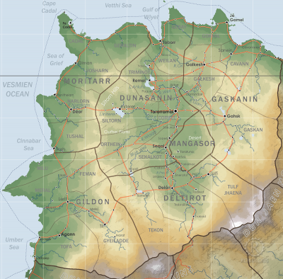
Hover to magnify | Go to world mapplugin-autotooltip__small plugin-autotooltip_bigAtlas: Ororr

[fmap-ororr.png] * Zoom out * Gildon * Moritarr * Deltirot * Dunasanin * Gaskanin * Mangasor * @ * @

Political | Geography

atlas nationmaps

atlas nationmaps

  • Name: Holy Motherland of Ororr
  • Government: Theocratic Republic
  • Capital: Torroramaiplugin-autotooltip__small plugin-autotooltip_bigTorroramâi

    Torroramâi (also Tororr, T'amai, [tɔ-ROR-ah-MAH-ee, or simply “The Capital”) is the administrative and religious capital of the modern nation-state of Ororr.

    Torroramai

    This is in a series of articles about Torroramai, capital city of the nation of Ororr.viridviridOrorrOrorrviridviridgreenvirid
  • Foundation: 52 MEplugin-autotooltip__small plugin-autotooltip_bigME

    ME is short for Modern Epoch, the modern method of numbering years.
    (Official)
  • Demonym: Ororran
  • Language: Dorounplugin-autotooltip__small plugin-autotooltip_bigDoroun language

    Doroun [doh-ROON, dɒ'ruːn] is the common language of Ororr, the principle language of law, trade, government and the Mother Church.

    Language

    language

    This is in a series of articles about Languages and Communication.

    Doroun is spoken as a first language in the regions of Dunasanin and Gaskanin, and as a second language in other regions. It developed from the languagelanguagelanguageOrorrlanguagelanguagelanguagelanguagelanguagelanguagelanguagelanguagelanguagelanguagelanguage…
    (official), regional languages
  • Religion: Mother Church of Ororr (Therism)plugin-autotooltip__small plugin-autotooltip_bigMother Church of Ororr (Therism)

    The Mother Church is the state religion of Ororr, which combines both religion and government in one institution. It is based on the teachings of the Great Prophet Therion, who in the early decades of the modern era raised an army that conquered much of northwestern OrorrOrorrOrorrOrorrOrorrMEMEOrorrMEMEOrorrOrorrHerHerHerHerHerHerHerHerHerher

New & Updated

Today's date


Pages & images

1112 articles 390 maps & images


Recent updates

All contents © 2024 Robert How, robulous.com

 
start.txt · Last modified: 2023/05/31 14:04 by Robert How · []